| Search JoyZine with Google Site Search! |
|
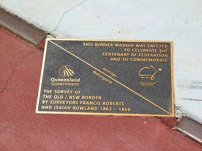
Line in the Sand
On June 6, 1859 letters patent were issued by Queen Victoria creating the Colony of Queensland and separating us forever from New South Wales. The birth of the colony also gave life to the borderline—the otherwise invisible boundary carved across maps of the commonwealth—that identifies our territory. And defining the border has always been important business touched with both controversy and humour. In towns that straddle or are close to the border, absurdity abounds. Brothels, for example, may advertise their wares on one side of the street, but are non-existent on the other. Such phenomena is not confined to just recent history. The anticipated Japanese air raids of World War II were a matter of great consternation. In Queensland, it was all lights out. However, in NSW—which in some cases was the other side of the street—the lights blazed on defiantly. Or take the great flu epidemic of 1919, which closed the border. Residents of Coolangatta with their banking and other business on the NSW side of the border were required to conduct their affairs via a small cigar box, into which documents were placed, to be pulled by string backwards and forwards across the imaginary divide. More than 15 health officials and 30 returned soldiers stood guard at the border while an additional 18 police were housed in tents on the allotments next to the station. There were guards on the beach and rocks below the border fence at Point Danger to keep a watchful eye on bathers. Crossing the bridge became big business and only one person was allowed to cross at a time. Some of the more desperate blokes were heard to ask the head sergeant if they could "kiss me tart goodbye through the fence". Queenslanders trapped in NSW were allowed into the Coolangatta camp side of the border where they were quarantined, disinfected and charged 7/6 (7 shillings and 6 pence) a day for the privilege. The story of just how the Queensland border came to be defined and drawn is a history lesson itself, and was very much a scientific business. While Queensland came into being in 1859, it was not until several years later than a comprehensive survey of the border was completed. Teams of men spent years toiling and living in less than comfortable conditions, relying upon their primitive instruments of measure. The Queensland border, as drawn on today's map, is the work of those surveyors, whose calculations were the result of often gruelling and life-threatening exploits. In 1863, explorer A.C. Gregory, the then Surveyor-General of Queensland, appointed Francis Roberts "to mark out in conjunction with a surveyor from NSW", the boundary line between the two colonies, commencing "at the extreme eastern point of Point Danger". The boundary was to be marked by a line drawn westerly "to the hilly country where the watershed has a definite character" and beyond. "Piles of stone" were to be adopted for "marking the angles in the line". Gregory recommended that the surveyors be issued with three breech loading carbines, to ward off "hostile" Aborigines. As it happened, it is recorded that the "natives" readily co-operated and in fact carried supplies on their backs over the McPherson Range, where pack horses could not be employed because of the rugged terrain. Roberts, who was supposed to work in conjunction with his NSW counterpart Isiah Rowland, completed his survey to the Dumaresq River near Texas, Qld in 1866. But the two fell out and Rowland completed a separate survey. The two surveys, independently marked, still stand. Their initials carved on a rock at Point Danger were destroyed by quarrying at the turn of the century. In 1879, NSW surveyor John B Cameron and Queensland surveyor George Watson undertook the survey of latitude 29 degrees, from the Barwon River to the South Australian border. Twelve months and 15 days after starting from the NSW border town of Barringun, the survey of the border west from a zero obelisk at Barringun to the South Australian border was finished. The intersection of the Queensland and South Australian borders is still known as Cameron's Corner, after the surveyor. After battling floods in both the survey of the border west from a zero obelisk at Barringun to the South Australian border was finished. The intersection of the Queensland and South Australian borders is still known as Cameron's Corner, after the surveyor. After battling floods in both the Warrego and Paroo river systems, and drought in the far west, the survey team returned to Barringun and recommenced work in the easterly direction, reaching the Barwon River in October 1881. |