| Search JoyZine with Google Site Search! |
Australia Decoded
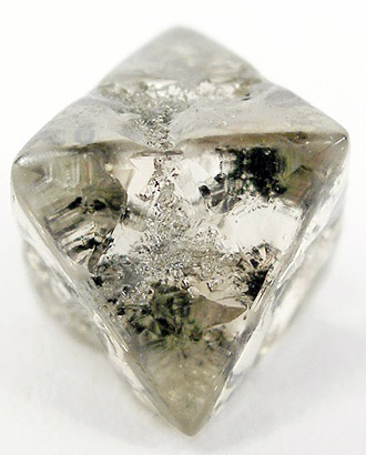
appeal—1. an application to a higher court to alter a decision of a lower court or tribunal, usually because of a mistake in law. A common example would be an appeal from a decision of a single judge, which would go to a bench of three judges (in the Federal Court of Australia). Another example would be an appeal from the Federal Court of Australia to the High Court of Australia. 2. a rehearing, as the result of such an application. appellant—the person, or a person's organisation or corporation, which lodges an appeal in a court. Applicants, appellants, respondents, defendants, etc., are generally called 'parties'. appellate court—any of several courts to which an appeal can be made. Apple Isle—(the...) Tasmania. apple tart—(rhyming slang) fart. apples—1. okay; all right; very well: e.g., Everything's apples down on the farm. 2. (rhyming slang—apples and pears) stairs. appropriation bill—a bill which, when passed by Parliament, will allow the government to spend money it has gathered from the community through taxes and charges. aquifer—a geological formation or group of formations capable of receiving, storing and transmitting significant quantities of water. Aquifer types include confined, unconfined and artesian. Arabana—a South Australian Aboriginal people whose traditional territory ranged from the Neales River on the west side of Lake Eyre west to Stuart Range; Macumba Creek south to Coward Springs; at Oodnadatta, Lora Creek, Lake Cadibarrawirracanna, and the Peake. Their boundary with the Kokata on the west is marked by the margin of the scarp of the western tableland near Coober Pedy. There were hordal groupings and their term for a hordal territory was wadlu; this has been mistaken for a tribal name. Aborigines accept Arabana but admit their grandparents would have preferred Ngarabana. In the 1980s, there were left only 8 speakers in the Arabana tribe, and another 8 among the Wangkangurru. These two groups are to be considered distinct ethnic groups, but they spoke dialects of the same language, or very close languages. Arafura Basin—a mainly offshore basin in the Arafura Sea on the northern margin of Australia, with Indonesia and New Guinea to the north. The geological provinces of the Arafura Basin comprise the central Goulburn Graben, the northern outer region, and the southern inshore terrace. The latter region extends into Indonesian waters. Strong oil shows have been demonstrated in conventional core samples taken from two wells in the Arafura-Goulburn areas. Arafura Sea—a shallow part of the Pacific Ocean, separating Australia from New Guinea and containing several Indonesian islands. It is bordered by the Banda Sea on the north and by the Timor Sea on the west. The Torres Strait, a treacherous passage on the east, connects the Arafura with the Coral Sea. The name is derived from the Portuguese mare aurifera, meaning ‘sea of gold’. The name dates back to 1623, when shipwrecked Portuguese were said to have seen gold-studded quartz on the coast of Arnhem Land. Arakwal—a tribe of the Bundjalung nation, which extends from Byron Bay south to Ballina and inland to Woodburn, Coraki and Lismore in New South Wales. Land claims on their behalf resulted in the creation of Arakwal National Park for their benefit; the transfer of Iron Bark Avenue Land and Paterson Street Land to the Arakwal Corporation; and the dedication of certain land to a nature reserve. Arakwal National Park—the 183ha park stretches from the lighthouse reserve on Australia's most easterly point south along Tallow Beach for nearly two kilometres. The Cape Byron headland stands on the most easterly point of the Australian mainland. A spectacular cliff-top walking track offers panoramic views of the ocean and north coast hinterland—an outstanding vantage point for viewing a diverse range of marine life, including turtles, dolphins and the humpback whales on their annual migration. A spectacular clifftop walking track offers panoramic views of the ocean and north coast hinterland. It's a great spot for watching turtles, dolphins and humpback whales on their annual migration. The recreation area has a wide range of vegetation, including coastal plant communities and rainforest that stretches down to the beach sand. The animals that live here are Creation of the Arakwal National Park is the result of the first Indigenous Land Use Agreement in Australia to provide for such a park. Located 2km east of Byron Bay. Aranda—an Aboriginal people of Central Australia, including the Northern Territory. Before 1900, the Aranda were one of the largest Aboriginal groups in Central Australia, but through the decimation of the population by tuberculosis and venereal disease, there were no more than 300 to 400 left by 1927. The Northern and Eastern Aranda lived in the MacDonnell Ranges. The Western Aranda lived in the best-watered section of the region, west of the mountains. The Southern Aranda lived in the driest part of the region, and had to confine their travel to the courses of the Hugh and the Finke rivers, the only two permanent water sources in the area. The sparseness of the country meant that the people were nomadic most of the time, although each local band had a permanent central camp, and each band moved within a circumscribed ancestral territory. There were no chiefs of units above the local bands. Souls of legendary ancestors associated with the founding of their totems floated through the air and impregnated women, and their souls were thus born again. It cannot be said that organized fighting or warfare of any kind existed. Relations between local groups were generally amicable, and people were able to travel over wide areas without fear. The Aranda were apparently equally friendly to whites, and there are no records of serious hostilities with them. Also known as Aranta and Arunta. Aranta—alternate spelling of Aranda). Ararat—an old Victorian gold-mining town, located in the foothills of the Pyrenees Mountains. The first Europeans in the area were the party of explorer Thomas Mitchell, on the Australia Felix expedition. Mitchell's positive report on the land east of the Grampians encouraged squatters to arrive with their flocks of sheep in the early 1800s. The Tjapwurong people inhabited the region prior to European settlement. The discovery of gold in 1854, just 6km west of present-day Ararat, triggered an influx of diggers to the town, and tensions developed. The strike that established the town was made as a result of racial strife on the Victorian goldfields. Due to anti-Asian sentiment, in 1855 the state government placed a £20 poll tax on every Chinese person entering a Victorian port. Ships from China began landing at South Australia, leaving the immigrants a walk of 500km or more to the Victorian goldfields. So it came about that one party of 700 Chinese miners came to rest on the future townsite while en route to Clunes. One member discovered alluvial gold in a stream, and the Canton Lead was established. Ninety-three kilograms of gold were shipped out in the first three weeks and 3 tons were officially escorted from town in the first three months. When the gold ran out, the town survived as a service centre to the already well-established pastoral properties, and as a regional administrative centre. Araucaria—Araucaria comes from 'Araucanos', a tribe in Chile that inhabited the region where the first Araucaria was discovered. Araucaria is a medium to large native Australian softwood, growing mainly in Queensland. Most commercially-available Araucaria is produced from managed plantations established by the Queensland State Government during the 1950s and 1960s. Araucaria plantations can be considered as a long-rotation crop, being intensively managed with the primary purpose of timber and veneer production. The management techniques now employed reflect a long period of research and development that have improved productivity through soil nutrition and tree breeding techniques. Since the first plantations, the production capacity of Araucaria has increased to 330,000 cubic metres per annum, with an expected rise to 400,000 cubic metres per annum by 2005. The qualities of Araucaria have always been recognised in Queensland; many older homes are still exhibiting the Araucaria used in their construction and finishing. Today, use of Araucaria has diversified, as the unique qualities of this remarkable timber are not only fully recognised, but also, much appreciated. Araucariaceae—a plant family (encompassing genus and species) of evolved conifers, known from the Triassic period of more than 250 million years ago. There are Triassic fossil examples of the Araucariaceae family, which reached maximum diversity during the Jurassic and Cretaceous periods, between 200 and 65 million years ago, with worldwide distribution. At the end of the Cretaceous, when dinosaurs became extinct, so too did the Araucariaceae in the Northern Hemisphere. Until about the middle of the Tertiary (30 million years ago), plants in the Araucariaceae family grew in the forests of the southern super-continent of Gondwana. The Araucariaceae family then began a slow decline in range and diversity, while flowering plants (angiosperms), which are better adapted to climate change, began to evolve and gradually displace the conifers. arbitration—a process in the Federal and State industrial-relations system where a dispute is resolved by a hearing in front of an third, independent party, who hears the evidence from each party. The decision of the third party, which resolves the dispute, then becomes law. On a national level, the third-party arbitrator is usually the Australian Industrial Relations Commission (AIRC). Arbitration Bill—(see: Conciliation and Arbitration Bill). Arcadia Formation—almost all of Australia's Triassic reptiles, and indeed Triassic fossils in general, come from a site known as The Crater, close to Carnarvon National Park in south-central Queensland. These deposits, known as the Arcadia Formation, are a thick sequence of sandstones and mudstones that formed in freshwater pools, lakes and streams around 230 million years ago (MYA). In most places these soft deposits have weathered to form a thick layer of soil, however in a few areas the intact rocks form brilliantly coloured layers, ranging in hue through red, orange, dark brown and purple. Most fossil material found in these layers are badly worn scraps that are difficult to identify. In fact, a lot of the fossil scraps are discovered in coprolites; the fossilised dung of the larger carnivorous animals that lived in the area. Archaean rocks—rocks older than 2,500 million years are "Archaean". Archaean gold deposits account for more than 60% of the world's gold. The formation of these deposits is linked to regional-scale processes at mid-crustal levels during regional metamorphism. These occur in blocks called "shields" or "cratons" that form the nucleus of all continents (e.g., Finland, Canada-USA, Canada-Greenland, Brazil, southern Africa and Australia). In Australia, most Archaean lode gold deposits occur in the Norseman-Wiluna greenstone belt of Western Australia. There are two tracts of Archaean nuclei located in Western Australia, the Yilgarn and Pilbara blocks. Archaeological and Aboriginal Preservation Act 1972 (VIC)—State legislation instituted by the Parliament of Victoria, for the preservation of archaeological and Aboriginal relics. The Act provided for an advisory committee that is empowered to keep a register and to advise on matters necessary for preservation. Archer Bend National Park—457,000ha of narrow, coastal floodplain in the forest and savannah woodland country of the upland of Queensland. The Archer and Coen rivers flow through the park and commonly spread over the floodplains in summer. The lagoons and swamps, which remain into the dry season, attract an abundance of birdlife. Access is difficult, and only possible during the dry season. The Bjelke-Petersen Government created the Archer Bend National Park in an effort to subvert the purchase of a pastoral lease by Mr John Koowarta on behalf of the Aranda people. Situated adjacent to the Rokeby National Park, these two parks cover the drier woodlands between McIlwraith Range and Archer River. Located in Cape York Peninsula, 180km south-west of Weipa, 450km from Cooktown. Archer Brothers—the Caboolture area's first free European settlers, the Archer brothers, moved to the area from New South Wales in September 1841. The brothers took up 'Durundur Station', comprising the entire Woodford district, on the banks of the Stanley River. This was the northernmost settlement in what was then the Colony of New South Wales. The Archers and their employees lived off the land until they could grow crops such as potatoes, melons, pumpkins and cabbages. archer fish—Toxotes jaculator, six species in a genus famous for the ability to bring down insects and other small prey from overhanging vegetation by spitting jets of water at them—and their aim is accurate for up to five feet. To enable them to do this, the palate is grooved, and when the tongue is pressed against the roof of the mouth to form a tube and the gills are forced shut, a jet of water results. They also possess excellent binocular vision to enable them to judge distance. In addition to this, they have the ability to make corrections for refraction between the water and air, and to make allowance for the curvature in the trajectory of the water jet. Archer fish occur in estuaries and freshwaters over a wide range, from South East Asia to the western Pacific. Archer River—extensive alluvial flats occur along the coastline in the west of this area. Repeated ridges and valleys with local relief of 10 metres form a large part of the lowland area. Further to the east, hills rise to about 500m elevation. Quaternary sediments overlie Cretaceous sediments which outcrop in the east. Levee banks along the Archer river support gallery rainforest. Vine forests and thorn scrubs are also found here. Extensive areas of woodland dominated by eucalypts and melaleucas occur within the area, and these species are emergents in vine thickets. Grasslands of seashore dropseed and samphires occur on the coastal eluvium. Low shrublands of fern-leaf grevillea, bloodwood, thryptomene and broad-leaved paperbark are found on soils of low fertility where waterlogging is common. Crocodiles occur in the river estuaries of this area, and its fauna is thought to be generally representative of the Cape York region. Located on the west side of Cape York, south and east of Aurun. Archer River Mission—an Aboriginal reserve reserve established in 1904. Missionaries confined children to their dormitories to isolate them from the influence of their own people and culture. Later, the mission's name was changed to Aurun, in recognition of a major language group within the area. Located on the Cape York Peninsula of Far North Queensland. Archer River Pastoral Holding—the subject of a lawsuit brought against former Premier of Queensland, Jo Bjelke-Petersen, for racial discrimination. In February 1976 the Aboriginal stockmen on the Archer River Pastoral Holding in Cape York Peninsula, led by John Koowarta, and availing themselves of "legislation passed by my Government, entered into a contract to purchase the property from its white owners. The Bjelke-Petersen government vetoed the transfer of the lease in June 1976. In December 1976 the government explained that the transfer came within the ambit of its September 1972 policy of not viewing favourably proposals to acquire large areas of additional land for development by Aborigines or Aboriginal groups. On 12 November 1977 the government declared the property a national park. On 11 May 1982 the High Court held that the government's veto contravened the Racial Discrimination Act 1975." Archer River Tribes—the Wik Mungkan people. The Wik languages and cultural region extend from south of the Archer River to the Edward. The area north of Archer to the Embley is part of what the Wik people call the Wik Way ("Difficult languages"). Archibald, Jules François—born at Kildare near Geelong in 1856 and Christened John Feltham Archibald, in his late teens he decided that he liked the idea of 'being born in France', and thus in a moment of eccentricity changed his name to Jules François Archibald. J F Archibald was a journalist, he was the founding editor of the Bulletin, and had a long and varied career in this field. Archibald started the Bulletin in 1880 in tandem with John Haynes, an Evening News confrère who was skilled in advertising and print production. 'Archibald's Correspondence', a regular column, was vastly popular and eventually brought writers such as Henry Lawson, and Banjo Patterson into the Bulletin offices. Archibald's obsession with his job came at a price. In 1903 poor health and depression forced him out of the editors chair and into Callan Park, a Sydney asylum. Archibald always defended his sanity and was bitter about his incarceration. Five years before his death, Archibald sold his stake in the Bulletin and offered his services to Smith's Weekly, an irreverent Sydney tabloid that thrived on gossip and humour. Archibald died at St Vincent's hospital on 10 September 1919, and was buried in the Catholic section of the Waverley Cemetery. His estate was considerable, amounting to nearly £90 000. Part of it paid for the large fountain in Hyde Park, executed by French sculptor François Sicard, which commemorates Australian-French solidarity in the First World War. Part of his estate went to establish the Australian Journalists' Association Benevolent Fund 'for the relief of distressed Australian journalists'. One tenth of his estate was set aside for the endowment of an annual art prize, to be judged by the trustees of the Art Gallery of New South Wales, which in its first year, 1921, amounted to £400. J F Archibald made a career out of disrespect, shaking a fist at authority and at 'all who reign over us'. The writer Joseph Furphy described him as 'offensively Australian'. Archibald Prize for Portraiture—one of Australia's oldest and best-known visual arts awards. The Archibald Prize began in 1921 with a bequest from Jules Francois Archibald, the editor of The Bulletin magazine. Archibald said the prize was to be awarded by the Trustees of the Art Gallery of New South Wales to 'the best portrait, preferentially of some man or woman distinguished in Art, Letters, Science or Politics, painted by an artist resident in Australasia during the 12 months preceding the date fixed by the Trustees for sending in the pictures'. The prize aims to encourage portraiture by supporting artists and celebrating the memory of great Australians. The prize of $35,000 and the publicity and recognition the prize generate for the winning painter encourages painters entering the competition to stretch their skills. The inclusion of a People's Choice Award in 1988 has subsequently ensured wide engagement by the public in the prize and the related Archibald exhibition at the Art Gallery of New South Wales every year. One quirky aspect of the Archibald competition is the Packing Room Prize, awarded by the workers behind the scenes who receive, unpack and hang all the entries. First awarded in 1991, the Packing Room Prize is adjudicated by the gallery's doorman, Steve Peters—who continues to claim his right to 51 per cent of the votes. This prize is traditionally awarded a couple of days before the Archibald, after the hanging of the finalists. Arckaringa Hills—an outback area surrounding Mount Arckaringa, and adjacent to the Painted Desert, in the breakaway country of northern South Australia. Arcoona Station—the national dumping site for Australia's low-level radioactive waste. The repository is on a pastoral lease at Arcoona Station, 20 kilometres east of Woomera in South Australia's north. The site had previously been leased to the Department of Defence (1947) for use as a temporary village while construction at Woomera was underway. argue the toss—disagree; dispute a decision. argy-bargy—high-flown, irrational, or insincere talk; blather; a stream of words intended to dupe, distract or befuddle the listener. The 'argy' part comes from the word “argument”. An old slang term for an argument is an argle (that's a 16th century term). This word is probably a combination with (or confusion with) “haggle”: if you put “argue” and “haggle” together you get argle. Over time this came to be repeated in the form argle-bargle. This form is around by the early 19th century. Argle-bargle probably emerged just because colloquial English likes rhymes and repetition. Then argle-bargle was shortened into arGee-barGee – because adding the “e” sound to the end of words is a common way to shorten them. Finally, the “g” was softened and we got the expression we've got today: argy-bargy (this form finally emerging in the late 19th century). Argyle apple—Eucalyptus cinerea, grows to an average of 20 to 30 feet tall. Young leaves are round, grey-green, and about 1 inch in diameter and grow opposite each other on the stem. They become longer and more oval shaped with pointed ends as they get older. The flowers are a creamy white and grow in 1 inch clusters. The bark is reddish-brown and fibrous. Grows in sunny, dry climates—does not tolerate cold weather, they are found commonly in the plains and savannas of Australia. The eucalyptus tree serves as primary food to the koala bear. Bees are attracted to the flowers of the eucalyptus, and the honey from these bees is highly prized in Australia. Because of its aromatic and long lasting quality, the young leaves are a "best seller" in flower stores. Argyle Diamond Mine—the world's biggest diamond mine, yielding more than thirty million carats of diamonds a year. Although only five per cent of the mine's production is gem quality, it has gained a world-wide reputation for its rare and valuable pink diamonds, as well as fine whites, champagnes and cognac-coloured diamonds. The Argyle Diamond Mine is owned by Rio Tinto and located in the East Kimberley region of Western Australia. Argyle diamonds—fall into three main categories: pink, champagne and white. Argyle diamonds have two outstanding features: they are harder than other diamonds and may fluoresce blue under ultra-violet light. The hardness factor of Argyle diamonds results from its unusual atomic structure. Although all diamonds share the same atomic structure, the atoms of Argyle diamonds are bonded together in more complex arrangements. This complex structure is also one of the major reasons for the deep colours of the Argyle product mix, especially the champagne and pink diamonds. Argyle region—the remote north-eastern corner of Western Australia boasts Lake Argyle, an artificial lake created for the Ord Development River Scheme, an agricultural project that seems to have paid off. The town of Kununurra is the centre of this scheme and has, apart from the lake that has become a tourist attraction as well, a nice walking trail in Hidden Valley, just outside town. The nearby port town of Wyndham is, however, now largely abandoned. Just across the border in the Northern Territory is Keep River National Park, with walks among strange rock formations, lush lagoons and caves with Aboriginal rock paintings, a wonderful and little visited place. arid—lacking enough water for things to grow; dry and barren. arid red earths—arid red earths, desert barns and the stony desert soils differ in texture from each other and in the degree of profile development, but are all red-brown to brown in colour. They make up a large proportion of the country utilized for grazing. The vegetation includes grasses and edible shrubs such as mulga on the arid red earths and shrub steppe on the desert loams. The stony desert soils carry a layer of stones on their surface and are almost treeless. arid wetlands—these environments support distinctive vegetation and provide habitat for many wetland-dependant animal species. There is great diversity in the range of desert wetland environments and the plants and animals they support but all have a common attribute: at least occasional abundance of water. Wetlands in the arid part of the Northern Territory range enormously in size from vast salt lakes to small spring-fed pools. A few hold permanent water but most of the wetlands are dry most of the time. To be considered a wetland, an area must at least occasionally be wet for long enough that it is used by plants and animals that require waterlogging or inundation during their life cycles and are visible to the naked eye. Another relatively large wetland type is bluebush swamp. A variety of habitats can be grouped as a wetland type called open fresh water basins. Soils are typically clayey and prevent water draining into the sub-soil. Large sandy rivers are also wetlands and even though surface water is relatively short lasting, they have a distinctive wetland vegetation, typified by river red gums. The only permanent natural wetlands are deep waterholes in rivers and wetlands created by permanent springs: waterholes, swamps and cascades. There are also a great many temporary springs that only flow after periods of sustained rainfall. Permanent and semi-permanent waterholes are virtually restricted to the mountain ranges: West MacDonnells, Davenport, Murchison and Dulcie ranges. The major exception is a few large semi-permanent waterholes in the Georgina River, on the southern part of the Barkly Tableland. The main threat to the desert wetlands of the arid NT is from introduced grasses and other weeds. These displace native species and create a greatly increased fuel load for wildfires. arid zone—areas receiving less than 250mm of annual rainfall in the south of Australia or 350mm (or sometimes higher) in the north. The arid zone occupies 70% of the continent. Three features control the ecosystem dynamics of the arid zone: unpredictable rainfall; occasional heavy and prolonged rainfall; and an ancient, well-sorted, infertile landscape. The arid zone has a unique, specialised desert fauna and flora, derived from ancestral forms that mainly lived in wet forests. The greatest diversity of taxa occurs within the ephemeral, low shrub and tall shrub forms, reflecting a tendency to be better competitors in unpredictable environments, especially where nutrient conditions are relatively generous. Aristolochiaceae—large woody climber with a dense covering of brown hairs on petioles, young shoots and inflorescences. Leaves ovate to elliptic, 7cm—25cm long, upper surface dark green and dull, lower surface with scattered hairs on veins; petiole 10--30 mm long, thickened and twisted. Racemes 2- to 6-flowered, usually axillary with moderately hairy, purplish flowers. Flowers summer to autumn in subtropical rainforest in coastal areas north from Wollongbar, near Lismore through coastal Queensland. Includes the Richmond butterfly vine (Pararistolochia praevenosa); mountain aristolochia (Aristolochia deltantha = laheyana); Indian birthwort (Aristolochia tagala) and Dutchman's pipe (Aristolochia tagala). aristotle—(rhyming slang) bottle, particularly one containing alcohol. Arkaroo—the Rainbow Serpent of the Adjnamathanha Dreamtime. Arkaroo, the legendary brown snake came down to slake a massive thirst from the waters of Lakes Callabonna and Frome. He drank and drank until the lakes were almost dry. Salt soon began to do its work. With a painful, rumbling gut the snake writhed his way up into the hills to the soothing coolness of the fresh water in the Yackie spring. On the way, Arkaroo's writhings formed the looping, meandering gorges and valleys of Arkaroola Creek, and where he urinated he left waterholes. Arkaroo Rock—an important Aboriginal art site in the Flinders Ranges National Park. The paintings, which were probably begun nearly 6000 years ago on the underside of the huge rock, feature ochre and charcoal images depicting the creation of Wilpena Pound. The rock is named for Akurra, the Dreaming serpent credited with creating many of the features within the Flinders Ranges, whose exploits are depicted here. Arkaroo Rock has been used by the Adnyamathanha people for thousands of years. The walking trail from the foot of Arkaroo Rock takes about 1-2 hours, revealing further Aboriginal art, including images of emu and bird tracks, snake lines and leaves. Arkaroola Wilderness Sanctuary—a private nature reserve in the Flinders Ranges of South Australia. Located in a semi-arid region, the 587.9 square kilometres of the sanctuary contain the most rugged chain of mountains in the Ranges. The main attraction is the half-day Ridgetop Tour in which visitors are taken by 4WD through an area of magnificent scenery that is otherwise restricted. This area is also considered one of the best places in the Southern Hemisphere for viewing the stars at night, and a large, computer-driven astronomical observatory offers a nightly tour through the universe. There are five walking trails on Arkaroola, each covering a different type of terrain and in some cases different vegetation. It is possible to see wildlife of the region on all the walks. An excellent natural history and geology museum at Arkaroola includes early Aboriginal artefacts, photographs, geological maps and fossils. It is an ideal starting point for any exploration of this remarkable area. Located about 600km north of Adelaide. Arkurra—alternate spelling of Arkaroo. Arltunga—the first town in Central Australia, born of an 1887 gold rush. A shanty-town sprang up and, at its peak, several hundred miners, some with their families, occupied the area. By 1912 most of the gold had been removed and activity in the area ceased. The remains of mines, old miner's camps and stone buildings are preserved on the Arltunga Historical Reserve. The town was named after a subgroup of the Arrernte Aborigines who had been living in the area for at least 22,000 years before the arrival of Europeans. Located 110km east of Alice Springs.
|