| Search JoyZine with Google Site Search! |
Australia Decoded
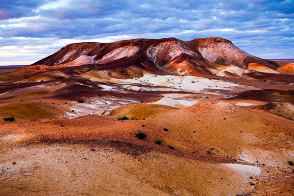
braided system (river or channel)—streams that divide into an interlacing network of several branching and reuniting channels separated from each other by islands or channel bars. brain-bucket—safety helmet worn by motorcycle riders, horse riders, etc. braising steak—chuck steak. brandy butter—a rich, sweet hard sauce made with brandy, butter and sugar, usually served with plum pudding at Christmas. brasco—a toilet. brass monkey weather—very cold weather. brass razoo—money, especially in relation to having none, or being worthless : e.g., something of no value is said to be "not worth a brass razoo". brassed—cheated. brassed off—bad-tempered; annoyed; disillusioned. brassy—1. brazen. 2. overdone; gaudy; tasteless. brave and bold—(rhyming slang) cold. breadbasket/breadbin—the stomach. break it down!—expression of disbelief or disagreement; plea for moderation. break open a coldie—have a drink, usually a can or bottle of beer. break the shackles—break free of something oppressive or confining: e.g., Globalisation means that there is a global network of social links, through which it is possible to break the shackles of locality and temporality and create a sense of presence and interaction from a long distance. brandy butter—a rich, sweet hard sauce made with brandy, butter and sugar, usually served with plum pudding at Christmas. brasco—a toilet. brass monkey weather—very cold weather. brass razoo—money, especially in relation to having none, or being worthless : e.g., something of no value is said to be "not worth a brass razoo". brassed—cheated. brassed off—bad-tempered; annoyed; disillusioned. brassy—1. brazen. 2. overdone; gaudy; tasteless. brave and bold—(rhyming slang) cold. breadbasket/breadbin—the stomach. break it down!—expression of disbelief or disagreement; plea for moderation. break open a coldie—have a drink, usually a can or bottle of beer. break the shackles—break free of something oppressive or confining: e.g., Globalisation means that there is a global network of social links, through which it is possible to break the shackles of locality and temporality and create a sense of presence and interaction from a long distance. breakaway country—wind, water, heat, cold and the Earth's natural minerals all play their part in shaping our landscape, but none more than Australia's arid regions. A superb example of nature's sculpturing is to be found at what is known as the Painted Desert. On the road that links to Cadney Homestead to Oodnadatta some 100km to the east are the Arckaringa Hills, an ancient landscape that was once laid down by a vast inland sea. Because rainfall in this region is low and infrequent, the ancient marine sediments encrusted along flat surfaces as it dried, rather than washing away. This duricrust involves cementation of the original material and results in a hard, resistant surface, in this case, silcrete (cemented by silica). As weathering and erosion takes place, these areas of duricrust protect the underlying strata but 'break away' on these edges to leave mesas or pedestal rocks. An ancient and richly coloured underlying strata is revealed on what is known as breakaway country. Breakaway Reserve—an Aboriginal reserve located on Antakirinja land. This is one of the hottest places in Australia, with summer temperatures often reaching 45°C, and ground temperatures reaching as high as 65°C. The region is characterised by many flat-topped mesas that at one stage in time would have been islands in a vast inland sea. Aboriginal people have lived in this area for thousands of years, and it is regarded as a significant region by the Antakirinja. Before white settlement the name of the area was 'Umoona', from the umoona tree found at the Breakaways and at the nearby and newly named Umoona Community in Coober Pedy. The Breakaway Reserve is jointly managed by the District Council of Coober Pedy and the Antakirinja Land Council. Located in the far north of South Australia. Breakaways—(the...) the colour bands of breakaway country shade from white and cream through vibrant yellow and deep ochre. As the sun sets, this scene displays a shifting tone-on-tone colouration that is a marvel to watch. At the edge of the reserve, the escarpment opens onto a vast plain spreading northwards onto a featureless landscape known as the Moon Plain. Located 22km north of Coober Pedy, a turnoff to the east leads to the reserve. breast (someone)—approach (someone) about something. breeding station—stud farm. breeze blocks—extruded concrete building blocks; a Besser block with air spaces. brekkie/brekky—breakfast. Bremer, Sir James John Gordon—On 24th August 1824 the ships H.M.S. Tamar, Countess of Harcourt and Lady Nelson set sail from Sydney bound for northern Australia. The expedition, commanded by Captain James J. Gordon Bremer, had the task of establishing a permanent military outpost in northern Australia, a region then lying outside the control of the Australian colonies or the British Empire. The expedition was not large. Aboard the three ships were a little over 100 soldiers, marines and convicts, a small number of officers' wives, and a handful of free men. The vessels were also laden with food supplies to last the first few months, livestock and plant seedlings from which the British hoped to become self-sufficient in food production, and prefabricated buildings to ensure the settlement’s officers were properly housed and the stores protected from the elements. One month after setting out Bremer and his party arrived off Cobourg Peninsula. After failing to find a suitable water supply they continued on to Melville Island. The expedition arrived on 26th September 1824 and Bremer immediately raised the flag on Luxmore Head, near the northern entrance to Apsley Strait, to proclaim Melville and Bathurst Islands British territory. Fresh water was soon discovered and work began on the construction of a fort and settlement the British named Fort Dundas at a locality that Tiwi people call Punata, near the present-day township of Pularumpi (Pirlangimpi). Work proceeded at a brisk pace so that by 12th November 1824, when Bremer departed Fort Dundas, construction of the fort and many buildings had been more or less completed. Bremer and Blackwood's Expedition—the Fly, under command of Captain FP Blackwood, made a minute survey of the Great Barrier Reef, and continued the survey of Captains Wickharn and Stokes. 1842-45. Bremer Bay—the town of Bremer Bay is located at the mouth of the Bremer River, situated on the south coast of Western Australia, 180km north-east of Albany. The town was actually named by John Septimus Roe, Surveyor-General in 1848, in honour of Sir James Gordon Bremer, who was the captain of the Tamar. Bremer Bay is a wide expanse of crystal clear, azure blue water, and an endless stretch of striking white sand. The main beach, only 10 minutes walk from the town, has a sheltered cove, popular for swimming. Excellent fishing from the rocks or the beach can be enjoyed. From approximately July to November each year, southern right whales calve in the calm waters of the numerous sheltered bays in the area. Point Anne provides a whale watching platform. Occasionally, humpback whales can be seen from a distance as well as other marine visitors such as dolphins and seals. Bremer River—1. a major tributary of the upper Brisbane River, Qld. More than 60% of the 2035sq km Bremer River catchment is bushland. The lower reaches are tidally influenced up to 17km from the junction with the Brisbane River, but exchange is slow in the dry season. There are three licensed discharge points, two sewage treatment plants and an abattoir. A hardboard-processing factory has a licence for land-based discharge. The Bremer also receives runoff from a wide range of uses from light and heavy industry, the Ipswich CBD, residential, agriculture and grazing land. The river's estuary has been classified as ‘extremely degraded' in the Moreton Bay study of 1999. 2. the major river flowing into the Wellstead Estuary, WA. The catchment area comprises mainly agricultural land and the Fitzgerald River National Park. Brewarrina—a small town that serves a large wool-producing area, to which crop production has been added over recent years. Located on the Barwon River, Brewarrina contains the Baiame's Ngunnu, the Aboriginal stone fish traps. Located 810km from Sydney and 98km from Bourke in New South Wales. Brewarrina fish traps—(Ngunnhu) a series of dry-stone weirs and ponds arranged in the form of a net across the Barwon River. Designed to withstand the high water flows of the river, they are teardrop shaped, with the convex wall facing upstream. Some of the pen walls are higher than others, enabling their use during both low and high water flows. This is combined with pond gates set at different locations, enabling fish to be caught as they migrated both upstream and downstream. While the Ngemba people are the custodians of the Ngunnhu, it was Baiame's wish that other tribes in the region, including the Morowari, Paarkinji, Weilwan, Barabinja, Ualarai and Kamilaroi should use it in an organised way. He allocated particular traps to each family group and made them responsible under Aboriginal law for their use and maintenance. The role of an ancestral being in creating built structures is extremely unusual in Aboriginal society, and makes both the structure and the story nationally important. The Brewarrina fish traps are located in New South Wales, south of Cunnamulla in Queensland. Bribie Island—located 70km north of Brisbane and 2 m above sea-level. The first European to make contact with Bribie Island was Matthew Flinders who landed in 1799. In 1823 John Oxley landed on the island and met a shipwrecked convict named Thomas Pamphlett, who showed him the entrance to the Brisbane River, thus leading to the subsequent settlement of the area. The island's name derives from a convict named Bribie from the Moreton Bay Penal Colony who became the first European to settle on the cay. It wasn't until 1953 that the island was connected to the mainland's electricity supply. Bribie Island's great transformation occurred in 1963 when the bridge was built. Since then it has become increasingly popular as a tourist and retirement destination. Its proximity to Brisbane has been a distinct advantage. The population now exceeds 7000. brick—1. good, honest, reliable person. 2. formerly ten pounds but now twenty dollars. 3. an amplifier. 4. prison sentence of ten years. brick short of a load—(be a...) lacking in intelligence; dull-witted; simple-minded. brickbat—1. a piece of brick used as a weapon. 2. a blunt criticism. brickfielder—a sudden, dust-bearing wind. brickie—a bricklayer. Bridgewater Bay—a huge body of water between the soaring cliffs of Cape Nelson and Cape Bridgewater and offers a wide, gently arcing, sandy beach. The rugged, volcanic headland—up to 130m high—takes the brunt of the crashing waves. Located 20km from Portland, Victoria. bridled nailtail wallaby—Onychogalea fraenata, a marsupial grazer weighing approximately six kilograms that must compete with sheep for its food. At the time of European settlement, the beautifully marked bridled nailtail wallaby was common in eastern Australia to the west of the Great Dividing Range. Saved from extinction by Earth Sanctuaries Foundation Australia. A small colony was found in Queensland, so the Foundation purchased six of these animals in 1998 to release at Scotia Earth Sanctuary in New South Wales. There are now more than 65 of these animals thriving in a feral-free habitat providing necessary feeding, such as brigalow. brief—a barrister. brigalow—Acacia harpophylla, a species of silvery wattle that gives the mosaic of open forest and woodland communities known as the Brigalow Belt its name. The canopy is usually 10-15m in height, and the dominant tree species that may occur within Brigalow include belah, gidgee, lancewood and bendee. Extensive stands of brigalow forests occurred on clay soils of south- and central-west Queensland. Now mostly cleared for agriculture, putting several native species of wildlife at risk of extinction. Many of the species that presently or formerly occurred in brigalow communities are now nationally threatened, including: bridled nailtail wallaby; northern hairy-nosed wombat; black-breasted button-quail; squatter pigeon; brigalow scaly-foot; ornamental snake; and black-throated finch. Brigalow Belt—a bioregion spanning inland and eastern Queensland from Townsville in the north to northern New South Wales, covering an area of about six million hectares. Despite such a large area, only about two per cent of the Brigalow Belt is protected in conservation reserves. Along the eastern boundary are scattered patches of semi-evergreen vine thickets with bright green leaves that are highly visible among the more silvery brigalow communities. These patches are related to rainforests and are remnants of the extensive subtropical rainforest vegetation that occupied much of the brigalow lands millions of years ago. Brigalow Belt North—a semi-arid bioregion that reaches the coast in the dry coastal corridor of Proserpine—Townsville. Characterised by woodlands of ironbarks, poplar box and Brown's box as well as brigalow, blackwood and gidgee. Brigalow Belt South—the sub-humid, central bioregion above the Great Artesian Basin. Characterised by eucalyptus woodlands and open forests of ironbarks, poplar box, spotted gum, cypress pine, bloodwoods, brigalow-belah forests and semi-evergreen vine thicket. brigalow scaly-foot—Paradelma orientalis, an endangered legless lizard. Occurs mostly in wooded areas west of the Great Dividing Range, in the eastern central and southern regions of Queensland. When disturbed, it raises its and anterior body well off the ground and flicks its tongue up and down. It makes no attempt to bite. Brindabella National Park—the northern-most park in the Australian Alps, lying within the Australian Capital Territory. The brindabella ecosystems provide a habitat for fauna that is not fostered by eucalypt woodlands. The Park is also significant as a corridor for native animal movement, connecting with the protected lands of the Cotter Catchment in the ACT and the Kosciuszko National Park to the immediate south and west. The Brindabella Park also provides opportunities for bushwalking, mountain biking, four-wheel driving, bird-watching and nature study. Brindella Range—a granite formation at the northern end of the Australian Alps, in the ACT. The major adjacent valleys of the Cotter and Goodradigbee Rivers are evidence of fault lines which were formed as the igneous intrusion occurred. These valleys have cut into older sedimentary rocks of the area. The Brindabella Valley was taken up for grazing in 1863 by the Franklin family. The high range had already begun to be used as relief pasture for cattle and sheep grazing during the non-winter months. The area is part of the territory traditionally occupied by the Walgalu Aboriginal people, who were joined in the summer months by the Ngarigo and Ngunawal for the bogong feasts. bring a plate—a common request made of guests invited to a party: indicates the need to bring your own plateful of food, or meat for the barbie. bring a ticket to get in—pertaining to the practice of bringing one's own alcohol to a function. bring on the dancing girls—expression designed to induce cheer and vitality. bring to book—call to accounting. brinnie/brinny—small stone or pebble. Brisbane—the first inhabitants arrived about 40,000 years ago from south-eastern Asia. Dutch mariners Willem Jansz (1606) and Jan Carstens (1623) explored the northern Queensland coast; and Captain Cook named Moreton Bay on May 16, 1770 during his voyage up the eastern coast. Named after Sir Thomas Macdougall Brisbane, Governor of New South Wales from 1820 to 1825. The penal colony at Moreton Bay was established by John Oxley, and with the Governor's permission the settlement was named Brisbane. In 1825, it was moved to the present site. An early European name, Edinglassie, quickly gave way to Brisbane Town. The first squatters, with thousands of sheep and cattle, moved into the Darling Downs in 1840 and in the following year free settlement began in Moreton Bay, and Brisbane Town held its first land sales. Much confusion followed, however. It was not until 1859 that the separate colony of Queensland was created and Brisbane, which until then had been a town without a colony, became the capital with a population of 5000. Straddling the broad Brisbane River, the city is one of Australia's largest river ports and its third largest urban centre. It's prosperity is based upon its proximity to markets in the Asia-Pacific region. The city is beautifully landscaped, has a fine array of public buildings, excellent shopping facilities and a modern public transport system. Brisbane, Sir Thomas Macdougall—British soldier and astronomical observer, appointed governor of New South Wales in 1821. At that time, the colonial territory encompassed what would later become the separate colony of Queensland. In need of an appropriate site for a second penal colony, Brisbane appointed John Oxley to head an expedition that resulted in the discovery of the Brisbane River in 1823, and the founding of what would become Brisbane Town in 1824. During his tenure, Governor Brisbane systematized the administration of the convict system, hiring out convicts to settlers for clearing land; reformed the currency; abolished censorship of the press; and established the observatory at Parramatta, in 1822. Both the river and the city of Brisbane were named in his honour. Brisbane Botanic Gardens—founded in 1970 and located on Mount Coot-tha, the Gardens features over 20,000 plants, representing approximately 5000 species from around the world. Arid, tropical and temperate plants are arranged in thematic and geographical regions, arranged over 52 hectares of land. Attractions include a Tropical Display Dome, Japanese Garden, Bonsai House and Fern House. The Australian Plant Communities section of the gardens occupies nearly half the total area, providing an opportunity to view Australian native plants represented in natural communities. Brisbane Forest Park—only 20 minutes from the city of Brisbane, the park is 28,500 hectares of bushland comprising national parks, state forests and council reserves. Brisbane Ranges National Park—Victoria's richest wildflower habitat. Set in a low range of mountains dissected by rocky gullies, the 7700ha park has preserved a diverse bird population and the greatest density of koalas in Victoria. In the 1870s, three thousand hectares of the Brisbane Ranges were reserved as a catchment area, to provide water to Geelong. In 1973, 1132ha were set aside as a national park, and enlarged to its present size of 7718ha in 1995. The park's sandy soils support nearly a quarter of Victoria's native flora. Historically, the Brisbane Ranges were formed about a million years ago when a line of weakness, or fault, developed in the earth's crust, uplifting the land lying to its west. Squatters arrived in the 1830s, concentrating their farming activities on the fertile land to the east and south along the Moorabool River. The goldrush began in 1851; gold was discovered in the Anakie hills. Goldmining flourished periodically until the early 1900s. Brisbane River—an ancient watercourse, presently occupying a channel that dates back at least to the earlier stages of the Pleistocene. The human significance of the Brisbane River dates back thousands of years before European settlement to when Aborigines of the Yugarabul language group knew the river as Mairwar. Following European discovery of the river by John Oxley in 1823 it was named after Sir Thomas Brisbane, the Governor of New South Wales at the time. A temporary settlement was made at Redcliffe the following year and in 1825 was moved to the banks of the Brisbane River, near where the Victoria Bridge stands today. Brisbane short-neck turtle—Emydura signata lives in the coastal waterways of northern New South Wales and far south-eastern Queensland. It is recognised by a pale yellowish stripe along the lower jaw to the side of the neck. When extended, the head and neck are much shorter than the length of the shell, which grows to about 20cm long. Each of the webbed forelimbs has five claws. It feeds on tadpoles, molluscs, small fishes, aquatic invertebrates and water plants. Also known as the Brisbane River turtle. Brisbane Town Penal Colony—in July 1825, after an unsuccessful attempt to settle at Redcliffe, a harsh penal colony was established on the present site of Brisbane, by order of the then Governor of New South Wales, Sir Thomas Brisbane, to take all the worst convicts. The site chosen by Commandant Miller was to the site of the present central business district, 27km up the river. Brisbane Valley—a region in south-east Queensland comprising Laidley Shire, Gatton Shire and Esk Shire. The region is 8028sq km in area, representing 36 per cent of the total area of Brisbane and Moreton Statistical Divisions. Brisbane Water National Park—a park of rugged sandstone country, featuring the Great Northern Walk. This 250km of planned walking track stretches from Sydney to Newcastle. The first 75km are within the bounds of the Sydney metropolitan area, with many easy access routes to public transport. Suitable for day walkers, weekend jaunts or a full 14-day excursion through scenic landscapes. Picnic facilities and amenities are available at Girrakool, Patonga and Pearl Beach. The park borders the Hawkesbury River, north of Sydney. Brissie—Brisbane. Brisso/Brizzo—a person who lives in Brisbane. bristlebirds—the Dasyornithidae is a small family of three bristlebirds in the genus Dasyornis. They are endemic to Australia. All three bristlebirds are skulkers in thick coastal or montane heath and scrub, and all are generally similar in appearance. Rufous bristlebird has a rusty crown and face and rather plain wings. Eastern bristlebird (D. brachypterus) and western bristlebird (D. longirostris) have less colorful head patterns but sport more rusty wings. It appears that they evolved on separate lineage from all other Australasian groups. Although they are not closely related, the three bristlebirds have evolved many similarities to the two species of scrub-birds (family Atrichornithidae), possibly in response to similar habitats. The two groups are rather similar in size and appearance; both have clear, ringing calls; and both groups have extremely elusive behavior within the dense, low vegetation that they frequent. So specialized have bristlebirds become that availability of habitat is now a major limiting factor. Even before European settlement they were relicts, restricted to scattered populations in isolated pockets of suitable, dense vegetation around the south-eastern and southern coasts of Australia. Both pastoral and coastal development, together with the increased incidence of fire, feral foxes and cats, and general human disturbance have put even greater pressure on the small remaining populations of these shy, essentially ground-dwelling birds. Among the bristlebirds, western is the most specialized, restricted to dwarf, waist-high, windswept coastal heathlands of southern Western Australia. Both rufous and eastern use a slightly broader range of habitats, including rainforest fringes, acacia scrub, lantana and melaleuca thickets, and (for eastern) a few woodlands that shelter tussock grasslands. Comparatively little is known about their life history, although it appears they mate for life, live in permanent territories until one of them dies, and share that territory (for at least a period) with their offspring. Their vocalizations are memorable: antiphonal duets between mated pairs being the most impressive of all. Brisvegas—Brisbane. Brit—an English person; a Pom. British Commonwealth of Nations—an association that emerged as countries of the British Empire shifted from Colonial to Dominion status. In the 1840s, self-government was introduced in Canada and so laid the foundation for the emergence of Canada as the first Dominion. Dominion status, consisting of internal self-government and a considerable degree of freedom in foreign relations, came to imply equality with Britain. Australia achieved Dominion status in 1901, New Zealand in 1907, South Africa in 1910 and the Irish Free State in 1921. The Formal legal recognition of full independent status came with the passage by the British Parliament of the Statute of Westminster in 1931. The sovereign status defined in the preamble of the Statute was conferred upon all the Dominions forthwith. A conference of Commonwealth prime ministers in 1949 decided to welcome India as the Commonwealth's first republican member. At the same time, the word 'British' was dropped from the association's title, to become the Commonwealth of Nations, a multiracial association of sovereign and equal states. British nuclear testing in Australia—between 1952 and 1991, 45 atomic tests (21 atmospheric, 24 underground) were conducted by the British military on Australian territory. The Monte-Bello Islands, off the north-west coast of Western Australia, were chosen as the site of the first tests. Here, the nuclear capability of the British was established by the explosion of a 25-kilotonne nuclear weapon in the hold of a naval vessel. Unknown to science and test personnel, the southerly Leeuwin current would wash the fallout back toward the WA coast. The British then moved to Maralinga in South Australia where testing was carried out on the sacred ground known to the Pitjantjatjara people as the "Field of Thunder". The traditional owners were left inside the test areas and the black rain that brought the radiation into their campgrounds horribly injured many. brittle gum—Eucalyptus mannifera, the bark is a shedding type to ground level, irregular, pinkish-gray plates or flakes. At first, it is yellow or pale orange, weathering to white and powdery, often with a red coloration in summer. It is especially attractive after a summer rain. Leaves are narrow and dull green, about 12cm long. Excellent for coppicing and responds well to this method of obtaining multi-stemmed, beautiful white trunks. The species tends to lose branches, even on a still day. It is widely planted in the cooler areas of Australia as a street tree due to its fine foliage and colorful trunk. Native to the mountain slopes and tablelands of New South Wales and Victoria. This species is frost hardy and tolerant of drought conditions, often growing in areas that receive from 500mm—1000 mm of rain per year. It grows well in poor soils containing clay or in shallow, rocky soils. Also known as red-spotted gum. brm brm—a car. broad accent—the peculiar Australian pronunciation of the English language. broad bean—Lima bean. broad between the ears—not very intelligent; witless. broad-faced potoroo—Potprous platyops is now extinct, but was the smallest of the potoroo species. Its body length was approximately 24cm, and its tail approximately 18cm, and had fat cheeks, giving it a broad-faced appearance. This potoroo inhabited the semi-arid, woodland and grassland areas of southern Western Australia. The species was first described in 1839 but has not been seen since 1875. Nothing is known of its biology. broad-headed snake—Hoplocephalus bungaroides, one of Australia’s most endangered snake species, so named because it raises and flattens its neck when threatened. Broad-headed snakes live under shallow, flat rocks on the very edge of precipices, where they hunt velvet geckoes. Confined to the Hawkesbury sandstone ridges of New South Wales, most of its former range is now buried under an expanding Sydney. Unfortunately, bush-rock collectors and other habitat disturbance further threaten the few locations where it still survives. broad-leaved paperbark—Melaleuca viridiflora, a small tree of from 3m—7m, with white, papery bark and stiff leaves. Bottlebrush-shaped flowers bloom in late autumn to winter. These are usually white to green, but red and crimson forms are known. Occurs across northern tropical Australia; along streams, in swampy areas and often in dense stands in open woodlands where the land may be seasonally flooded. Aboriginals used this tree as a source for fresh water stored beneath the bark. broad-leaved tea-tree—Melaleuca leucadendron var. viridiflora, is also known as swamp tea tree or paperbark tea tree. Young leaves are steeped in hot water and drunk for general sickness, colds and coughs. Aboriginal people around the Cape York Peninsula use this plant for the general soothing of body aches. The Belyuen around the Cox Peninsula, near Darwin, use the plant as a sniffling medicine and the soft papery bark for bandaging. An infusion of broad-leaved tea-tree leaves and inflorescence is rich in mucins, essential oils, flavonoids and tannins. It is particularly suitable for incorporation in soothing and relaxing bath preparations, mirroring its traditional Aboriginal use. Additionally it may be recommended for use in creams and lotions intended to alleviate stressed and strained skin.
|