| Search JoyZine with Google Site Search! |
Australia Decoded
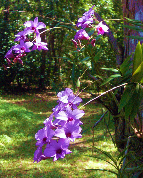
cooba—Acacia salicina, a small hardwood tree found scattered through the dry inland areas of eastern Australia. Its harsh environment gives rise to marked features and attractive irregularity in the grain. Reddish hues are not uncommon and some highly prized pieces show marked tones of orange. Fine finishes can be attained due to its relatively fine grain and even texture. Cooba is a species of very limited occurrence, and is only sourced through scavenging and milling condemned or naturally fallen trees. Coober Pedy—the largest producer of opal in the world, producing an estimated 70% of the world's precious opal. Located in the heart of South Australia's outback, the town presents a desolate landscape pockmarked by the tailing of countless opal mines. After World War I, returning soldiers introduced the arrangement of living underground in "dugouts", as many had done in the trenches of France. About 80 per cent of the town's population now live underground as a means of escaping the extreme heat ( 50° to 60°C). Places of business such as hotels and pubs have also been dug into the reddish marl which fosters the opal. With the arrival of the ‘white man’ in search of opal, the Aboriginal people named the area ‘Kupaku Piti’, translated to ‘white man’s hole’. Kupaku is a Muntunjarra word for white man and piti is an Antakirinja word for hole. Coober Pedy now has one of the most multicultural communities in Australia, with an estimated 45 nationalities in a population of approximately 3500. It is situated 845km north of Adelaide on the Stuart Highway. cooee—a sound used to attract attention, especially at a distance. cooee bird—the large cuckoo Eudynamys orientalis, also known as the storm bird, noted for its mournful cry preceding rain. coohoy nut—the walnut Endiandra palmerstonii of northern Queensland rainforests Cook, Captain James—English navigator best known for his voyages to the Pacific Ocean and his application of scientific methods to exploration and cartography. Cook had observed a solar eclipse in 1766 and used it to determine the longitude of Newfoundland; these findings were published in the Transactions of the Royal Society. After his return to England in 1767, Cook was commissioned a lieutenant in the Royal Navy. In 1768 the Royal Society requested the Admiralty's aid in observing the transit of Venus at Tahiti, to occur in June 1769, and Cook was given command of the expedition. Secret orders from the Admiralty instructed Cook to search for terra australis incognita, the "unknown southern land". Cook and the Endeavour left Plymouth on Aug. 26, 1768. In addition to its crew the Endeavour carried an astronomer, two botanists—Joseph Banks and Daniel Solander—and artists. Exploring two thousand miles of the east coast of New Holland, as Australia was then provisionally called, Cook claimed the country in the name of King George III. cooked it!—spoiled, ruined, bungled, made a mess of: e.g., Now you've really cooked it! cooking with gas/oil—going or happening satisfactorily; doing well. Cooktown—the most significant European settlement on Cape York Peninsula, Cooktown's history has been etched by the 1770 careening of James Cook's Endeavour and its role as a supply port for the Palmer River goldfields, which were worked between 1873 and 1890. Cooktown is commemorated as the landing site of Captain Cook in 1770, when he beached his crippled barque Endeavour on the 17th of June 1770, on a coral reef off the Cape of Tribulation. Captain Cook and his crew spent nearly two months as the continent's first European "settlement", camped on the then-desolate banks of the Endeavour River. Today, Cooktown is a sleepy little hamlet of about 1,000 residents, approximately 330km by sometimes unsealed road from Cairns, FNQ. Cooktown azure—Ogyris aenone, a butterfly coloured pale metallic blue on the upper surfaces, with a narrow black edge to the costa and margin of each forewing. Underneath, they are grey with black markings edged in metallic green. The pupa is brown with dark markings, and has a length of 1.6 cms. Pupation occurs in a bark crevice, and the caterpillars hide by day in such crevices. At night they emerge to feed on various mistletoe. The caterpillars are always attended by ants, generally the Australian golden ant. The species is found in Queensland, on the north coast and inland near Leyburn, and near Millmerran. Cooktown ironwood—Erythrophleum chlorostachys, a tree common throughout northern Australia, not just around Cooktown, growing on well-drained soils in association with bloodwoods, stringybarks and other eucalypts. It is a highly poisonous tree, known in parts of Western Australia as 'camel poison'. All parts of the tree are toxic, even dry leaves, although it seems that little corellas can eat the seeds, and it is a preferred food source of some marsupials in the northern Australian savannahs (e.g. rock ringtail possum and northern brushtail possum). Suckering shoots are particularly dangerous. Domestic animals have been poisoned by leaves accidentally trapped in the side of trucks which were transporting them; 50g of leaves is enough to kill. During the 1864-65 journey of the Jardine brothers from Rockhampton to Cape York, 30 of their 42 horses and 50 of their 250 cattle died after eating a poisonous plant near the Wenlock River on Cape York peninsula. It seems likely that the plant involved was the Cooktown ironwood. The hard timber, which is one of the densest of any Australian tree, is resistant to termite attack. It was widely used by early settlers for railway sleepers and fence posts. Traditionally, Aboriginal people have made good use of the hard timber. Infusions of the leaves have been used to cure scabies, while burning green leaves repels mosquitoes and sand flies. The tree produces creamy-green flowers in spikes which eventually turn into flat, brown, woody, seed pods up to 14cm long. Cooktown orchid—the common name refers to the northern Queensland town, Cooktown, which lies within the distribution of the species on the Endeavour River, named by Captain Cook after his ship was repaired there in 1770. Plants are up to 80cm in height, comprising 3-20 flowering canes up to 1.5 cm in diameter. Three to six lance-shaped leaves, 5-12cm long, are arranged on the upper parts of the pseudobulbs. The stems bearing the flowers are 10 to 40 cm long, carrying up to 20 flowers. Each flower is about 3 to 6 cm wide and usually coloured deep to pale lilac or, rarely, white. It usually flowers in the dry season in the wild, but may flower throughout the year in cultivation. on 19 November 1959 the Cooktown orchid was proclaimed as the floral emblem of Queensland. cool bananas—wow, etc. cool temperate rainforests—occur at altitudes of 900m—1500 m, and receive between 1750mm to 3000mm of rain annually. When it is not raining, they are frequently shrouded in mists. Cool temperate rainforests usually display two strata, exhibiting a uniform canopy of just two or three species. The commonest dominant species is the Antarctic beech. Stranglers and palms are absent, as is plank buttressing, but the tree trunks can be of massive size. Large vines and epiphytes are rarely present, although thin wiry vines and a few small ferns and orchids may occur. Ground ferns and tree ferns are very common, and mossy epiphytes and lichens are in greatest abundance. Mosses, lichens and brightly coloured fungi grow upon the trunks of trees and carpet and the forest floor. Major stands of cool temperate rainforest occur at high altitude, throughout the Border Ranges and Lamington National Parks. Tasmania contains Australia's largest tracts of cool temperate rainforest, covering around 10% of the state. cool the tinnies and warm the set—expression of the Aussie 'ocker' getting ready to watch sport on television while drinking copious amounts of beer. coolabah-black box woodland—an ecological community found on the grey, self-mulching clays of the periodically waterlogged floodplains, swamp margins, ephemeral wetlands, and stream levees of the Darling Riverine Plains bioregion and Brigalow Belt South bioregion. The structure of the community may vary from tall riparian woodlands to very open, savannah-like grassy woodlands with a sparse mid-storey of shrubs and saplings. Typically, these woodlands form mosaics with grasslands and wetlands. coolah grass—Panicum queenslandicum, a native grass very common in the pastures of the Northern Territory, Queensland, and New South Wales. This extremely drought-tolerant grass is a valuable asset to grazing country. Coolah Tops National Park—12,117ha of tall open forest on a narrow plateau of the Liverpool Ranges. Coolah Tops is a highly scenic area featuring Australia's largest snow gum and giant grass trees, waterfalls, and lookouts with views to the Warrumbungles and Mount Kaputar. The plateau consists generally of mature stands of tall, open eucalypt forest with a grassy understorey and occasional pockets of tea-tree swamp. The main species present are silvertop stringybark, forest ribbon gum, snow gum and black sally, dominated by tea tree. Wooded areas provide shelter for gliders, grey kangaroos, wallabies, cockatoos, eagles, rare owls and many other native species. At Coolah Tops National Park, the Warrumbungle Range joins the Great Divide and the Liverpool Range. Located in New South Wales. coolamon—a basin-like vessel of wood or bark used by Aborigines to hold water and other liquids, and for a variety of other purposes such as carrying a baby. coolamon roseapple—Syzygium moorei, a rainforest tree from south-east Queensland and north-east NSW. The tree has large, thick, dark green leaves and masses of watermelon-pink flowers along the larger branches. Large, red, spherical fruit follows, growing to 60mm. Trees are slow growing and may take more than 10 years to flower. Also known as durobby and watermelon tree. Coolangatta—one of the first resorts built in Queensland, Coolangatta nestles the Queensland border and is the twin town to Tweed Head, on the NSW side. Situated at the southern end of the Gold Coast (30 min drive from Surfers Paradise), the town was named after a ship that was wrecked on the coast in the 1840s. It is said that the word 'coolangatta' is an Anglicised Aboriginal word meaning 'beautiful place'. Coolangatta Beach and Greenmount Beach form a continuous strand backed by some foreshore greenery. To the immediate east of Greenmount Beach is a small, rocky, elevated headland topped by Pat Fagan Park, which offers fine views of Byron Bay and the Gold Coast. On the eastern side of the headland is Rainbow Bay, a small but very popular cove. On its eastern side is Snapper Rocks, at which point the coast veers southwards again, opening out to Duranbah Beach, which is a noted surfing location. Behind the beach is a foreshore area atop the rugged headland of Point Danger (named by Captain Cook), on which sits a lighthouse. Coolangatta is a popular family holiday destination. Coolgardie—site of the greatest gold rush in West Australian history. On 17 September 1892 a young Queenslander, Arthur Wellesly Bayley, rode into Southern Cross with 554 ounces of gold that he had discovered at Fly Flat, as Coolgardie was then known. Overnight the miners at the Southern Cross diggings flocked to the more lucrative eastern fields. The town's development was typical of the goldfields' cycle of boom and bust. The railway was completed in 1896, and two years later the town was the third largest in WA (after Perth and Fremantle). Yet by WWI the town was in decline, and ceased to be a municipality in 1921. Coolgardie now is a self-promoted 'ghost town' supporting a population of nearly 2000 people, primarily through tourism. The main street is still wide enough for a camel train to turn around, and is still lined with imposing, nineteenth-century public buildings. Located in the eastern goldfields region of Western Australia. Coolgardie bioregion—granite strata of Yilgarn Craton with Archaean greenstone intrusions in parallel belts. Drainage is occluded. Mallees and scrubs on sandplains associated with lateritised uplands, playas and granite outcrops. Diverse woodlands rich in endemic eucalypts, on low greenstone hills, valley alluvials and broad plains of calcareous earths. In the west, the scrubs are rich in endemic Proteaceae, in the east they are rich in endemic acacias. Arid to semi-arid, warm Mediterranean. Coolgardie safe—invented in the goldfields of Western Australia in the late 1890s to reduce the ever-present danger of food poisoning. The "safe" utilised wet sacking over a container or frame, thereby keeping out flies and reducing the interior temperature. coolibah—any of several eucalypts, especially the blue-leaved Eucalyptus microtheca found across central and northern Australia. This is a fibrous-barked tree yielding a durable timber and occurring in seasonally flooded areas. Its survival is now threatened by water mismanagement which causes the water table to drop too low. Like the banksia species, the coolibah survives the hot, dry season with a deep and spreading root system that taps into artesian water. Cooloola monster—a bright orange, cricket-like insect, Cooloola propator, discovered in the late 1970s in Cooloola National Park. Distribution: Cooloola, Blackdown Tableland, Bundaberg (in sugarcane fields). Cooloola National Park—a coastal Queensland park, close to World Heritage-listed Fraser Island. Also known as the Great Sandy National Park, the highly porous Cooloola sand mass enables rainwater to seep into a saturated zone, the top of which is called the water table. In areas where this table is higher than the ground's surface, freshwater springs may occur. The CSIRO estimates the water volume at 9000 million m to the power of 3. In the driest continent on earth, the temptation to tap this supply and disrupt the ecology has sparked bitter opposition. cooloolah—Callitris columellaris, often used for telegraph poles. Cooma—the main commercial centre of the Snowy Mountains region and the headquarters of the Snowy Mountains Scheme. Cooma is situated at the junction of the Monaro Highway and the Snowy Mountains Highway in New South Wales. Cooma Cottage—pioneering pastoralist Cornelius O'Brien built this single storied colonial cottage in 1835. The original section is an intact weatherboard bungalow, with verandah, dating from 1835. From 1839 until his death in 1873 it was the home of explorer Hamilton Hume. A creative owner-builder, Hume added his version of Palladian-style wings and a Greek Revival portico. Set in a pastoral landscape, the house represents an extraordinary taxonomy of vernacular building techniques and includes a fine, mid-nineteenth century stables outbuilding. Hume was the leader of the first European party to see the Yass Plains in 1821. He returned in 1824 on his crucial excursion to Port Phillip Bay. These trips were responsible for the opening up of Australia in general, and the local area in particular, to European settlement. Situated on the Yass River, Cooma Cottage is in the heart of some of New South Wales' richest sheep grazing country. The cottage forms part of an important group of rural houses along the Yass River, including Douro and Hardwicke. The plains were an attraction to settlers in the 1820s and settlement of the Yass area was sufficient to warrant the establishment of a post office in Yass by 1835. The cottage, 4km from Yass on Yass Valley Way is now a museum with a display relating to the life of Hume. Coonabarabran—a country town on the Castlereagh River, at the edge of the Warrumbungles, 451km north-west of Sydney, between Gilgandra and Gunnedah. The vast, cypress-pine forests of the Pilliga scrub lie to the north-west of town, and Warrumbungle National Park is 27km to the west. Coongie Lakes—a major unpolluted, unregulated river and wetlands. They are also one of among the most ecologically rich wetlands in Australia, listed under the Ramsar Convention. The wetlands change dramatically depending on the amount of rainwater flowing down the Cooper Creek tributaries from southern Queensland. In extreme flood conditions, this north-west corner of the state is transformed into a huge lake. Approximately 20,000 waterfowl occupy the system virtually all year round. Notable fauna include the threatened night parrot, white-bellied sea-eagle, freckled duck, musk duck, magpie goose, brolga, little egret, Latham's snipe, painted snipe, intermediate egret and the spotless crake. Coongie Lakes lies in the Channel Country bioregion. Cooper Creek—a major Aboriginal trading route across Australia prior to European settlement. Now it is a refuge for rare, relict flora and fauna that have evolved from when Australia was part of Gondwana. During the wet depressions associated with monsoonal troughs, heavy deluges fill Cooper Creek and its tributaries. The floodwaters from here flow down from Queensland to Lake Eyre, Australia's largest inland lake, attracting waterbirds by the hundreds of thousands. The Cooper flows for about 1400km through the Channel Country of western Queensland and into north-eastern South Australia. Its drainage area is around 296,000sq km of cattle-grazing country and desert. In the form of a complex system of anastomosing channels, disjunct waterholes and flood channels, it extends over muddy floodplains and through intervening dunefields towards the parched, muddy, and salt-crusted bed of Lake Eyre, causing the “dead heart” of Australia to come alive perhaps once a decade. Cooper Creek is located midway between the Daintree River and Cape Tribulation, Queensland. Coopracambra National Park—protects a heritage river, rare flora and fauna, and a diverse landscape in one of the most remote sections of Victoria. The 35,000ha park is renowned for the red sandstone gorge of the Genoa River and the surrounding granite peaks. Part of the park has been designated as a wilderness area. Apart from Beehive Falls on the eastern edge, the park is accessible only to experienced bushwalkers. Coorong—(the...) a narrow neck of sand dunes stretching 145km along the south-east coast of South Australia, is part of the Australian consciousness largely because it was the location for the children's book (and later film), Storm Boy by Colin Thiele. Geologically, the Coorong is a set of complex and ancient sand dunes, the oldest of which was formed about 120,000 years ago. Then there is another dune formation which is about 80,000 years old. Some of that dune still remains on Younghusband Peninsula. The modern day Coorong was formed between 6,000 and 20,000 years ago when the sea rose to form an island on top of the 80,000-year-old dune. This produced a lagoon behind the present line of seaward dunes. Originally, there were probably many access points from the sea to the lagoon but over time the wind swept sand to fill them in, creating this unique neck of land. Historically, there were five Aboriginal tribal groupings living on the Coorong. They are still known as the Ngarrindjeri people. It wasn't until 1837 that two men, Strangways and Hutchinson, discovered the narrow lake, and the following year a Captain Gill, having been wrecked near the mouth of the Murray, rowed a dinghy up the Coorong. The area's commercial potential was always restricted. Over the last half of the 19th century sheep farmers moved into the area but they were hampered by rabbit plagues and the mysterious 'coast disease'. As early as 1914 sections of the Coorong were being set aside as a national park. However, it wasn't until 1966 that the official Coorong National Park was established. In 1968 an additional 6840ha were set apart as a game reserve. However, the eons-long cycle of still summer waters blocked behind the sandbars and then a mighty rush of winter rains and spring-melted snows no longer operates, and there is great concern for the health of the lower Murray, the great lakes, and the Coorong. Coorong Lagoon—a narrow saltwater lagoon, insulated from the Southern Ocean by the towering sand dunes of Younghusband Peninsula. The Coorong Lagoon receives water by exchange with the sea via rainfall and groundwater inputs; and freshwater inflow from the Murray River occurs where the lagoon meets the sea. Never more than three kilometres wide, this unique and complex system of shallow saltpans is a major waterbird habitat, boasting over 240 different species. Each September through November, migratory waders arrive from the northern hemisphere. When these migrants depart during March and April, the endangered orange-bellied parrots and their young arrive to escape the harsh Tasmanian winter. The lagoon waters are freshwater soaks, and one of the few sources of fresh water for regional fauna. The wetlands around the lagoon cover 140,500ha and include Lake Alexandria and Lake Albert. The Coorong was listed by the Ramsar International Wetlands Convention as one of the ten most important wetlands in the Murray-Darling Basin. It was also included on the list of 'Wetlands of International Importance especially as Waterfowl Habitat', maintained by the International Union for the Conservation of Nature and Natural Resources on 21 December, 1975 and the 'Agreement between Australia, Japan and China for the Protection of Migratory Birds and Birds in Danger of Extinction, and their Environment' on 30 April, 1981. The Coorong is also an archeological site of national importance, with middens and burial sites throughout the park giving evidence of Aboriginal occupation over tens of thousands of years. Located within the Coorong National Park, south-east of Adelaide, South Australia. Coorong National Park—an area of world-wide biological significance. It is a major breeding ground for pelicans, ducks, swans and ibis. During the warmer months the Coorong becomes home to thousands of migratory birds such as sandpipers, stilts and stints. The park contains a representative sample of coastal and salt-influenced terrestrial habitats, as well as an unusual set of aquatic habitats in the Coorong Lagoon and ephemeral lakes. The Coorong is of important Aboriginal significance and is renowned for its archaeological sites. Next to the Southern Ocean there is a range of sand dunes known as the Younghusband Peninsula, and on the eastern side there is a composite range of Pleistocene dunes. The depression between these parallel dunes is principally occupied by a saltwater lagoon about 100km long, the Coorong Lagoon. In the south, the presence of water in the interdunal depression becomes seasonal and the lagoon is replaced by a series of ephemeral lakes and swampy mud flats. The Coorong National Park covers 140,050ha and includes the Lake Alexandrina and Lake Albert. Located in South Australia, south-east of Adelaide. Cootamundra Girls' Home—the first of several training homes for Aboriginal children set up by the Aborigines Protection Board of New South Wales. Girls in the home were trained as domestic servants and sent out to work for white, middle-class families. The primary aim of the Board was not to establish a self-renewing source of cheap labour, but the destruction of Aboriginal society and eradication of Aboriginals as an identifiable group. The isolation of Aboriginal girls was intended as a means of reducing the Aboriginal birthrate. While in the home, they were not allowed to communicate with their families, and were often told that their parents were dead—and given false birth certificates. The Cootamundra Girls' Home operated from 1912-1968. Cootamundra wattle—Acacia baileyana, the floral emblem of the small rural township of Cootamundra, which is located on the western slopes of New South Wales, about 350km south-west of Sydney. Cootamundra wattle is a well-known Australian species, principally on account of its popularity in cultivation (both within Australia and abroad). Acacia baileyana was originally described by Baron von Mueller in 1888, based on a plant cultivated in 1876 at Bowen Park, Brisbane, by the Queensland botanist, Frederick Manson Bailey (after whom the species was named). Acacia baileyana has a very restricted natural distribution which is confined to the vicinity of Cootamundra, hence its common name. In its native habitat the species is found in sheltered situations, generally on elevated sites, between Stockinbingal, Temora, Cootamundra and Bethungra (a distance of only about 50km, east to west). Cootamundra wattle grows into a large, bushy shrub or small tree, commonly reaching 5m—10m tall, and is typically freely branching from 1m—2m above the ground. Plants growing in dense regrowth stands tend to be somewhat spindly whereas in open sites they are more robust. The short bipinnate leaves are usually blue-grey in colour, the flower heads are lemon yellow and arranged as elongated, showy racemes, and the relatively large pods are flat and covered with a white bloom when young. The species flowers mostly between June and early September, with individual trees flowering for only a few weeks. cop—something profitable such as a job, position or particular situation; e.g., He's on a terrific cop since he started working for himself. 2. receive: e.g., He copped a blow to his ego. cop a blast—receive a severe reprimand; be strongly criticised. cop a load of that—have a look at that (amazing sight). cop a serve—receive a severe reprimand; be strongly criticised. cop it rough—suffer unfairly: e.g., Many people have to cop it rough. cop it sweet—endure without complaint. cop some stick—receive a barrage of, be the recipient of severe and mocking criticism, sarcasm. cop the backlash—receive a reaction that is excessive. cop the blue—take the blame. cop this!—have a look at this! copper—(Brit.) a policeman. copper-tailed skink—Ctenotus taeniolatus, a skink found throughout New South Wales, Queensland and Victoria. copperhead—a venomous snake of two varieties. The lowland copperhead (Austrelaps superbus) prefers to live in swampy or marshy areas, overwintering in animal burrows close to water. Lowland copperheads occur in the far south-eastern corner of South Australia and over much of southern Victoria. The alpine copperhead (Austrelaps ramsayi) is widespread at alpine and subalpine elevations over much of eastern Victoria. Although timid, they are potentially dangerous to humans. coppery brushtail possum—Tricosurus vulpecula johnstoni, a marsupial that eats the leaves of eucalyptus and other trees, and some fruits. It is nocturnal and spends the day in a tree hollow or log. It spends most of the time in the trees (arboreal).cor!—expression of amazement, surprise. coral—an aquatic animal of the Cnidarian group, corals are related to anemones, jellyfish, bluebottles and hydroids. The basic structure of all corals is the polyp, which is also the basic building block of a coral colony. The new polyps of most coral species remain joined together as they grow, allowing food to move between the polyps and throughout the entire colony. In hard corals, the polyp's soft tissue is protected by a limestone container that it constructs with its own secretions. Coral Bay—a bauxite-rich region lined with lateritic sea cliffs. Leaching of more soluble minerals leaves aluminium oxides, resulting in red cliffs of 60% bauxite. Green algae coats shore rocks. Located 1200km north of Perth in Western Australia, on the southern end of the world's largest fringing coral reef (Ningaloo Reef). The reef stretches about 2km outward into the Indian Ocean, and the bay provides protected waters. The coastline encompasses many miles of deserted white-sand beaches. During walks you might see turtles laying their eggs (seasonal), dolphins playing off-shore, manta rays feeding and many different land and sea birds. A small settlement of a few houses, stores, restaurants and accommodation, Coral Bay is the place where the reef meets the beach and the wonders of Australia’s largest fringing coral reef are accessible within one hundred metres of the shore. coral bleaching—a result of a breakdown of the symbiotic relationship between corals and unicellular algae (zooxanthellae). These microscopic plants live within the coral tissue and provide the coral both with food for growth and their normal healthy colour. Without the zooxanthellae that normally inhabit the coral polyp, the coral slowly starves to death. One major cause of this is rising water temperatures, which block the photosynthetic reaction that converts carbon dioxide into sugar. This results in a build-up of products that poison the zooxanthellae. To save itself, the coral spits out the zooxanthellae and some of its own tissue, leaving the coral a bleached white. The bleached coral can recover, but only if cooler water temperatures return and the algae are able to grow again. coral cay—a small, low island or bank composed of sand and coral fragments (variant spelling and pronunciation of key, as in the Florida Keys). Coral Coast—starts at Coral Bay, WA, continuing along the coast until the small town of Onslow. The area offers a strong sense of eco-tourism with spectacular landscape and fabulous coral reefs. coral reef—a massive, wave-resistant structure, built largely by coral, and consisting of skeletal and chemically precipitated material, being best developed where mean annual temperature is 23 to 25 degrees C. The reef builds slowly towards the surface of the water, at the rate of a few millimetres per year. Once the reef reaches sea level, the corals cannot survive, and the reef grows horizontally. Reefs build as a result of the growth of corals and other biota, and also from accumulation of sand and rubble formed when the organisms are broken down by waves and animals, such as worms and sponges, that bore into the coral. Coral Sea—the SW arm of the Pacific Ocean, between Australia, New Guinea and Vanuatu. It is a territory with no native inhabitants, consisting of sand and coral reefs and islands (or cays); administered from Canberra by the Department of the Environment, Sport and Territories. Coral Sea Island Territory—a group of reefs and tiny atolls in the Coral Sea, beyond Queensland's Barrier Reef. The coral and sand islands are quite small, with some grass and low vegetation cover. There is no fresh water. Two species of sea turtle nest in the area, and at least twenty-four bird species have been recorded. Only Willis Island is inhabited, with four Meteorological Bureau staff. Unmanned weather stations, beacons and a lighthouse are located on several other islands and reefs. The islands were established as a Territory of the Commonwealth of Australia under the Coral Sea Islands Act 1969. The Coral Sea Islands Act 1969 was amended in 1997 to extend the boundaries of the Coral Sea Islands Territory around Elizabeth and Middleton reefs. Elizabeth and Middleton are 160km north of Lord Howe Island, at the southernmost extremity of the Coral Sea. The reefs are presently accepted as part of Australia's continental shelf. Coral Sea Islands—scattered over some 1 million square kilometers of ocean, the Coral Sea Islands were declared a territory of Australia in 1969. They are uninhabited except for a small meteorological staff on the Willis Islets. Automated weather stations, beacons, and a lighthouse occupy many other islands and reefs. They are an important nesting area for birds and turtles. The territory is administered from Canberra by the Department of the Environment, Sport, and Territories. coral trout—Plectropoma maculatum, an excellent eating fish with firm white flesh. Colouring ranges from pink to red to brown, with small but brilliant blue spots over the body and head. The colouration can vary with time of day, the surrounding habitat and the type of activity the fish is pursuing. Generally, the largest coral trout are found well offshore in the coral reef waters of Queensland, the Northern Territory and Western Australia. Coranderrk Aboriginal Station—a successful and competitive farming community. Within four years of its establishment in 1861, the mission’s residents had cleared much of the property to develop a competitive farming community. They had also established a bakery, a butcher shop, a schoolhouse and numerous residences. The general sentiment within the community was that the land was too valuable for Aboriginal people, and by 1874 the Aborigines Protection Board (APB) was attempting to move the residents off Coranderrk. The residents walked 40 miles to Melbourne’s Victorian Parliament to protest against the proposed closure. Coranderrk remained operating as an Aboriginal station until its closure in 1924, but during this time there were further protests regarding payment for their work, which the APB refused to do. The residents of Coranderrk Mission were provided with rations for their labour, but never were they paid. With the passing of the ‘Half-Caste’ Act (1886) numbers at Coranderrk began to dwindle. In 1924 Coranderrk closed and the majority of the residents moved to Lake Tyers Mission Station. The land went to soldier settlements in 1948, a scheme under which few Aboriginal people were allocated any of their own land. Coranderrk Bushland Reserve—a 142ha nature reserve adjacent to and managed by Healesville Sanctuary, near Melbourne, Victoria. In 1963, a 2m-high security fence was erected around the reserve, partially excluding European foxes and fully excluding domestic dogs, as well as enclosing a resident population of eastern grey kangaroos and swamp wallabies. The reserve is a significant remnant of foothills forest and its associated fauna. The Coranderrk is home to a variety of species of native flora and fauna including many state orchid species. The reserve is used by researchers, special interest groups and a variety of field naturalist clubs and provides a valuable education resource for student groups and universities. Coranderrk Cemetery—contains the grave of William Barak. Barak as a young boy was present at the signing of John Batman's 'treaty' for the acquisition of Kulin lands in 1835. Barak died in 1903. Barak's gravestone was vandalised in the 1940s and taken to the Shire Depot, until being rediscovered in 1955. The Coranderrk Cemetery was handed over to descendants of the Wurundjeri, the traditional owners of the land, in 1991. Located near Healesville. cordial—a very sweet, fruit-flavored drink made by adding cordial syrup to water. Sweeter than Kool-Aid, red cordial especially has a reputation for creating a "sugar high" corduroy road—a road made of tree-trunks laid across swampy ground. corella—any of three small, white cockatoos. The western corella is confined to the extreme south-west of Western Australia, and the long-billed corella is found in the south-east. Little corellas are widespread throughout Australia, their range expanding along with land clearance and the increase in water sources, often forming large flocks along watercourses and where seeding grasses are found. Corin Forest—Canberra's "mountain playground", featuring a ski resort with year-round recreation facilities. All-year-round for adults, there is an 800 meter bobsled/ alpine slide, curving down the granite boulder-strewn mountainside, through towering Mountain Ash trees. Spectators can watch from a viewing area half-way up the bobsled run. Located 45 minutes from Parliament House. Corio Bay—an arm of Port Phillip Bay and part of the Westernport Ramsar site. Although it is a popular location for recreational activities, the bay maintains a large diversity of flora and fauna. It provides habitat for many threatened species, and protects an important spawning aggregation site. Corio Bay is located in the Westernport area, Victoria. This region is listed under the Ramsar Convention as an area of significant biological importance. cork up!—shut up! corked—drunk; intoxicated. corkie—cork (bruised) thigh in Australian Rules football. corkwood—Hakea chordophylla, a small tree that grows to 8m, generally with a crooked trunk and branches. The thick bark grows as ridges, with a corklike appearance. The species grows in moisture-accumulating sites in overall arid areas in the Gascoyne, Murchison and Goldfields in Western Australia. corn chips—tortilla chips. corner country—the area in which the borders of New South Wales, Queensland and South Australia meet. cornflour—corn starch. Cornish cream—(Brit.) clotted cream (as traditionally served in Cornwall, England). Cornish pastie—(Brit.) seasoned meat and vegetables baked in a pastry envelope (originated in Cornwall, England). cornstalk—a resident of New South Wales. Coronation Hill—site of the former South Alligator uranium mines in the 1950s. The exploration and associated work undertaken in the late 1980s showed that beneath the planned, new open-cut operation and adjacent to gold mineralisation, a viable uranium deposit still existed, with further indications of uranium mineralisation to the east. The uranium ore contained high-grade gold mineralisation. Thus, if mining had proceeded, there was more than a realistic possibility that high-grade uranium ore would be mined and potentially processed, contrary to the claims of the joint venturers. If the proposal had not been stopped, it would have opened the floodgate for more uranium exploration. Instead, this area was incorporated into Kakadu. The decision by the Hawke (Labor) government on not to allow mining at Coronation Hill was a major victory not only for the conservation of the region, but also for the traditional owners. Guratba, as the indigenous Jawoyn people know Coronation Hill, is a sacred site. corporations power—the provision in the Australian Constitution (Section 5l (xx)) that empowers the Commonwealth to legislate for the control and regulation of certain corporations, including trading and financial corporations, on a national basis. corroboree—a dance ceremony, of which song and rhythmical musical accompaniment are an integral part, and which may be sacred and ritualised or non-sacred, occasional, and informal. Hence loosely, in extended senses, especially with reference to a meeting or assembly, or to festivity generally. Corroboree Billabong—part of the Mary River system, out on the flood plain, in Northern Territory. Corroboree Billabong is truly a wonderful place, a fishing trip to this billabong is much more than that. Whilst Corroboree consistently delivers good fishing, it is also one of the Top End's most scenic billabongs. Mixed in with your day chasing barramundi, you may see a wide variety of water birds, sea eagles, crocodiles, water buffalo and wild pigs. Located 150km east of Darwin. corroboree frog—Pseudophryne corroboree, a frog with bright yellow and black striped markings on the top and sides of its body and legs. The belly is marbled black and white or black and yellow. The skin on the back is slightly granular with low warts. The warts form ridges that run down the length of the body. The skin on the belly is smooth. The toes are not webbed. This frog inhabits bogs, marshlands and sclerophyll forests under logs and vegetation in the heart of Kosciuszko National Park. It has a short breeding season because it lives in such a cold environment. In the summer months males call from concealed sites in sphagnum bogs and mating occurs in depressions in the sphagnum moss. Females lay their eggs in nests that are hollowed out near the roots of sphagnum clumps. The embryos develop inside the eggs and the tadpoles hatch out when the winter rains or the melting snow (in spring) flood the nest. As the tadpoles approach metamorphosis their gold and black colour patterns become evident. This species is Australia's most endangered frog; it is on the brink of extinction. Their decline appears to be linked mainly with climate change and an exotic pathogen known as Chytrid fungus. Corymbia—one of three genera comprising the eucalypts: specifically, the bloodwoods and the ghost gums.
|