| Search JoyZine with Google Site Search! |
Australia Decoded
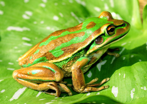
grab—(Australian Rules football) a mark. grab a few zeds—have a short nap. graft—to toil, work very hard: e.g., He's been grafting in the goldfields for years. grammar school—1. a selective State secondary school with a mainly academic curriculum. 2. a private school. grampers/gramps—grandfather. Grampians National Park—preserves almost a third of Victoria’s native fauna, and a large percentage of its animals. The 167,000ha national park contains nearly 970 species of Victorian native plants, and over 200 recorded species of birds. The park is known as Gariwerd to the Djab Wurrung and the Jardwadjali tribes who lived in the area. In the south of the park are some constructions that are unique within Australia—kilometres of complex channels were carved, using simple digging sticks, to direct eels into nets, which were then cooked in large earthen ovens. The eel catching was an important ceremonial time, and neighbouring family groups would gather for the feasting. Additionally, over two-thirds of the Aboriginal rock art sites in Victoria are located here. The earliest known paintings were done 22,500 years ago and the latest ones 5,000 years ago. Major Mitchell was the first white man to explore and report upon the Gariwerd/Grampian area (1836). He named the ranges after an area in Scotland, which he considered similar. The park surrounds and includes the Grampians Range. Grampians Ranges—the southern extremity of the Great Dividing Range. The Grampians comprise three main ranges covering approximately 1000sq km. Water stretches include Lake Bellfield, with 12 reservoirs and lakes that form the heart of a massive water supply system. The Djab Wurrung rent inhabitants built complex channels below the southern slopes, where they trapped eels. The area constitutes the most important rock art sites in south-east Australia, with some 276 sites recorded sites. The earliest known paintings have dated at 22,500 years of age, and the latest ones at 5,000 years. Rock art left by the Buandik (Buganditj) and Jardwa (Jarwadjal) tribes is apparent in the north-west area of the Grampians and in the Victoria Range. The first white man known to explore the Grampians region was Major Mitchell in 1836. He named the ranges after an area in Scotland which he considered similar. The region surrounds and includes the Grampians National Park. Grand Arch at Jenolan—(see: Jenolan Caves). grand old lady—pertaining to something old, antique, worthwhile restoring for posterity, such as a house or boat. Grange—original name for the town of Hamilton, in the western Victorian plains. granny—1. grandmother. 2 (cap.) the Sydney Morning Herald. granny flat—a dwelling for an elderly relative, built on the property of the main house. Originated at a time when dual-occupancy of a house was not permitted under town planning regulations. Now, these self-contained units are often rented to students or others of low income. Granny Smith apple—a bright green, firm-fleshed, tart cooking apple. Grant, Lieutenant James—commander of the Lady Nelson, a new vessel designed for exploration and fitted with a centre-board keel. His instructions were to proceed to Australia to prosecute "the discovery and survey of the unknown parts of the coast of New Holland". He left England on 18 March 1800 and at the Cape of Good Hope received a letter from the English Secretary of State, the De of Portland, instructing him to sail through the newly-discovered Bass Strait. Late in 1800, sailing from South Africa to Port Jackson (Sydney Cove), Lieutenant James Grant undertook the first eastwards passage along the southern coast of Australia in the HMS Lady Nelson. Grant came in sight of Australia near the present boundary of South Australia and Victoria on 3 December 1800, and the Lady Nelson successfully passed through the strait, the first ship sailing from England to Australia to do so. Grant did not land, nor did he map the coast of South Australia, but he did name Mount Gambier after a Lord of the Admiralty, Mount Schank after the inventor of the sliding keel, Cape Banks, Cape Northumberland and Portland Bay after the English Secretary of State. The Lady Nelson arrived at Port Jackson on 16th December 180, having completed her maiden voyage in ten months. Lt. Grant was ordered to return and survey the deep bay he had sailed across in Bass Strait, and to make a general survey of the south coast. He left on 6 March 1801, sailed as far as Western Port (of which a survey was made), discovered and named Churchill Island, and was back at Sydney on 14 May. grasp the nettle—tackle an unpleasant or difficult task with fortitude and resolution. grass—1. an informer, especially a police informer. 2. betray, especially to police. grass parrot—any of various parrots frequenting grassy country, especially species of Psephotus and Neophema. Psephotus is a genus of four species of Australian parakeets. All species show considerable sexual dimorphism. These species have traditionally been placed in the genus Psephotus along with the red-rumped parrot, but a molecular study analysing nuclear and mitochondrial DNA found that the red-rumped parrot was an early offshoot in a clade of several genera of broad-tailed parrot, with the other species nested deeply within. The genus Neophema is also an Australian genus, with six or seven species. They are small, basically dull green parrots differentiated by patches of other coloursThe genus has some sexual dichromatism, with males having brighter hues. Sometimes the broad-tailed parrots are considered a subfamily. In this case, Neophema and Bourke's parrot are united in the tribeNeophemini. mtDNA sequence data (Miyaki et al. 1998) suggests that the former may be correct, but the latter almost certainly is not. Rather, it appears that the group would need to include more closely related forms, such as the budgerigar and the Pezoporus ground-parrots. However, while Joseph et al. (2011) also found Neophema to be related to both Bourke's parrot and ground-parrots and form part of the tribe Pezoporini, they are not related to the budgerigar. There are 6 or 7 species: Blue-winged parrot, Neophema chrysostoma; Elegant parrot, Neophema elegans; Rock parrot, Neophema petrophila; Orange-bellied parrot, Neophema chrysogaster; Turquoise parrot, Neophema pulchella; Scarlet-chested parrot, Neophema splendida. Depending on the author, Neopsephotus bourkii (Bourke's parrot) may also be considered a member of this genus. grass tree—Xanthorrhoea, a genus of about 15 species, comprising perennials with an underground stem with or without a tall, rough stem above the ground. X. australis is probably the most widely distributed species. It usually develops a rough trunk, which may be branched, and which is coloured black, the result of surviving many bush fires. Commonly known as black boy, although the trunks only start appearing after many years of growth. Long, narrow, sedge-like leaves arch upward from the tops of the trunks. Old plants produce flower spikes to 4-5m high, with very small, white flowers covering the upper part of the spike. The Cadigal made use of every part of the plant: the stem of the flower spike was used for spear shafts and for making fire, nectar and young shoots were eaten, and the plant’s resin was used as a glue. Grass trees produce a hard, waterproof resin at the base of the leaves, which melts when gently warmed and sets hard when it cools. This resin was used as a cement to fasten stone flakes and axe-heads to their handles, and to form a gripping surface for stone knives. Endemic to coastal heaths and both wet and dry forests of Tasmania, Victoria, New South Wales, Australian Capital Territory and South Australia. grass-leaved hakea—Hakea multilineata, after Baron Christian Ludwig von Hake, a patron of botany. Grows to 15' x 6' with narrow, oblong leaves and long spikes of red, pink or white flowers, and is found in gravelly heaths in south Western Australia. grassland earless dragon—Tympanocryptis lineata pinguicolla, a small dragon-lizard measuring up to 21cm in length. It is well camouflaged and each individual has unique back pattern markings. It lives in and around grass tussocks as well as small holes in the ground that are also used by invertebrates such as wolf spiders and crickets, and eats mainly spiders and insects. In the past, this earless dragon was found near Melbourne, Rutherglen, Bathurst, Cooma and Canberra. Recent information suggests that it has disappeared from Victoria and Bathurst. Populations elsewhere are small and fragmented, and restricted to only three locations: the Majura and Jerrabomberra Valleys in the ACT, and near Cooma in NSW. In the Canberra-Monaro region, it is found in native, temperate grassland that is dominated by perennial tussock-forming species. Only about 0.5 per cent or 1000 hectares of the ACT's original natural temperate grassland still remains—and only a subset of this supports the grassland dragon. grasslands—cover an enormous area of inland Australia. The most extensive are dominated by the hummock-forming spinifex, and occupy just about the entire arid zone where soils are sandy or there are rocky mountains and hills. Spinifex tends to be replaced by cane grass on dune crests in the driest areas of the Tirari Desert. Fire is an essential part of spinifex reproductive strategy. Ageing hummocks begin to break down in the centre, forming distinctive annuli. They eventually disintegrate into scattered blobs. Regeneration requires a fire to initiate germination and growth. Spinifex is a fire-increasing grass and Latz argues that it has increased in importance considerably since introduction of Aboriginal burning to the arid zone (at least 22,000 BP)—to the detriment of other less fire-adapted taxa. Today, maintenance of diversity in the spinifex lands is directly related to maintenance of an active regime of patch burning. The southern Australian grasslands are among the most altered of all native communities. The few relatively undisturbed remnants are found in places like old cemeteries and along rail reserves—these areas are now valuable archives of the nature and composition of native grasslands. By comparison, the northern grasslands, while heavily grazed, are relatively intact. Alpine grasslands are common in open, well drained areas. They are replaced by herbfields of various kinds at the highest, most exposed elevations. grasswren—Amytornis, a genus of birds that are the larger relatives of the better known fairy-wrens. They are renowned for living in remote areas, often in inhospitable habitats. Many species of grasswren are sparsely distributed through limited ranges, and many species are not well known. grassy box woodland—landscapes of scattered eucalypt trees with rolling understories of native grasses and wildflowers. They once covered vast areas of what is now the wheat-sheep country across south-eastern Australia. They are part of the land that the early explorer, Major Thomas Mitchell, described as unencumbered by too much wood, yet possessing enough for all purposes. A range of tree species grow in grassy box woodlands. Yellow box and Blakely's red gum are most common on the tablelands. White box woodlands are generally found on fertile lower slopes along the western side of the Great Dividing Range. Grey box, fuzzy box then bimble box woodlands occur on the lower rainfall slopes and plains further west. The understorey was originally dominated by kangaroo grass and snow grass in the east, with wallaby grass, spear grasses and windmill grass increasing westward. A rich diversity of herbs (including yam daisies), lilies, orchids and other wildflowers are found scattered throughout this native grassy understorey, especially on the more fertile sites where white box is found. Further west where the seasons are drier,and on poorer soils in the eastern part of the slopes, this rolling, native grassland can give way to a more shrubby understorey. Originally, the grassy box woodlands formed relatively continuous vegetation from southern Queensland to Victoria, west of the Great Dividing Range. Woodland communities generally occur on the most fertile soils and as a result have been preferentially cleared for agriculture. Woodlands are among the most endangered and poorly conserved ecosystems in Australia. gravel rash—(joc.) the result of grovelling behaviour. graveyard chompers—false teeth. Gravox—Bisto; brown gravy mix. grazier—1. person who feeds cattle for market. 2. a large-scale sheep-farmer or cattle-farmer. grazing country—land suitable for the raising of sheep or cattle. grazing district—an area particularly suitable for raising sheep or cattle. grazing license—a limited form of Crown tenure used for small or short-term pastoral operations. A grazing license may be granted within an area held under a Crown lease, such as a national park or a pastoral lease. greaseproof paper—paper that is impermeable to oil or grease, used in cooking; parchment (baking) paper. greasies—fish and chips, or other oily, take-away food. greasy—1. a shearer of sheep. 2. a male cook for workers in the outback. Great Anabranch—a looping 460km subsidiary course of the Darling River on the edge of the outback in remotest New South Wales looks far from great these days. Its lower reaches ran dry two years ago after ten years of drought. Now its bed is dry red dust. Great Artesian Basin—prior to European settlement, Aborigines used the mound springs of the Great Artesian Basin. Mound springs are natural outlets of the artesian aquifers from which groundwater flows to the surface. Mound springs were and still are a valuable resource for the support of wildlife. Europeans first discovered the artesian groundwater of the Great Artesian Basin in 1878 when a shallow bore sunk near Bourke in New South Wales produced flowing water. The first artesian flow in Queensland was obtained near Cunnamulla in 1887. The assurance of a reliable water supply for settlers and their stock meant the development of a valuable sheep and cattle industry. The water from the Great Artesian Basin continues to be of vital importance to outback regions of Queensland, New South Wales and South Australia. This water is often the only available supply for towns and properties for their domestic and stock watering requirements. great Australian adjective—the word 'bloody—notably Australia's most extensively used adjective. Great Australian Basin—a vast area of Mesozoic sedimentation. The basin is poorly endowed with valuable minerals, its most important resource being groundwater. The geology consists of continental sandstones and shales, massive quartzose sands, marine shales and calcareous sandstones overlain by Cainozoic alluvial and lacustrine sediments. Laterites and silcretes, clay pans and windblown sand form cover materials. Covering 1.7sq km of eastern Australia, the Great Australian Basin was formed during the Cretaceous period, about 140 million years ago. Great Australian Bight—the world's longest south-facing shoreline, best known as a crucial calving area for the southern right whale. Also provides a vital habitat for the other whale species, the endangered Australian sea lion, great white sharks and scores of fish species. The ocean floor also maintains a unique but largely unexplored community of plants and animals. Great Australian Bight Marine Park—(GABMP) was established to protect the biological diversity of the Bight while providing for ecologically sustainable use of the park’s natural resources. The park is divided into zones which allows the management of specific threatening processes and provides the ability to implement different levels of protection for the park’s assets. The Head of Bight is a significant breeding and calving area for the endangered southern right whale. The vulnerable Australian sea lion also breed in colonies at the base of the Bunda Cliffs, and are the only mainland breeding colonies in Australia. Unique marine plants, animals, and sediments found nowhere else in the world are present in the park. It is of oceanographic importance because its waters are transitional between warm and cold – linking the Indian and Pacific oceans. It has the longest ice-free east-west extent of coastline in the Southern Hemisphere and it is adjacent to the only circumpolar ocean. great (Australian) outback—the outback, especially in romanticised literary depiction. Great Barrier Reef World Heritage Site—one of Australia's first, and the world's largest, World Heritage areas, extending 2000km and covering an area of 35 million hectares on the north-east continental shelf of Australia. The Great Barrier Reef's diversity reflects the maturity of the ecosystem, which has evolved over hundreds of thousands of years. It is the world's most extensive coral reef system and is one of the world's richest areas in terms of faunal diversity, and contains extensive areas of seagrass, mangrove, soft-bottom communities and island communities. The reef is not a continuous barrier, but a broken maze of coral reefs and coral cays. There are an estimated 1500 species of fish and more than 300 species of hard, reef-building corals. More than 4000 mollusc species and over 400 species of sponge have been identified. Other well-represented animal groups include anemones, marine worms, crustaceans and echinoderms (starfish, sea urchins, etc). The extensive seagrass beds are an important feeding ground for the dugong, a mammal species internationally listed as endangered. The reef also supports a wide variety of fleshy algae that are heavily grazed by turtles, fish, sea urchins and molluscs. The reef contains nesting grounds of world significance for the endangered green and loggerhead turtles. It is also a breeding area for humpback whales, which come from the Antarctic to give birth to their young in the warm waters. The islands and cays support several hundred bird species, many of which have breeding colonies there. The World Heritage property is also of cultural importance, containing many middens and other archaeological sites of Aboriginal or Torres Strait Islander origin. There are over 30 historic shipwrecks in the area, and on the islands are ruins and operating lighthouses that are of cultural and historical significance. About 98 per cent of the World Heritage property is within the Great Barrier Reef Marine Park, the remainder being Queensland waters and islands. Great Britain—the principal island of the United Kingdom, including England, Scotland and Wales, and administratively including adjacent islands, except the Isle of Man and the Channel Islands. Great Central Road—the most accessible route linking the Red Centre to Western Australia and the Northern Territory. The route also passes directly into Aboriginal communities in the Central Reserves, the Ngaanyatjara lands, extending some 890km from Laverton in Western Australia to the Northern Territory border, near the Docker River Community. It is a legal requirement for travellers to hold a valid Transit Permit at the time of travel. The section from Docker River to Yulara is usually referred to as part of the Gunbarrel Highway, although it is technically a part of the Great Central Road. Great Cumbung Swamp—a wetland terminal basin in which the water salinity is not significantly higher than the receiving waters, from the Lachlan River. Water seepage into the shallow groundwater table leaches salt from the root zone and prevents a salinity build-up. The Great Cumbung Swamp comprises principally an area of common reed. The surrounding Lachlan floodplain is covered by river red gum with areas of black box woodland. Following flooding, widespread breeding of many species of waterbirds occurs. great divide—1. the boundary between life and death. 2. (cap.) the Great Dividing Range. Great Dividing Range—the crest of the highlands belt. Running parallel to the southeast margin of the Australian continent, the range traverses 3000km parallel to the eastern coast from Cape York on the northern tip of Queensland to the western half of Victoria. The Blue Mountains of NSW, the Grampians of Victoria and the Glass House Mountains of Queensland are all part of The Great Dividing Range. Rivers on the eastern side of the range flow in an easterly direction towards the Pacific Ocean and Tasman Sea, whilst rivers on the western side flow into the Murray-Darling River Basin, which waters the vast agricultural area of Queensland, NSW and Victoria. Known variously as the Snowy Mountains, the High Country and the Bogongs. The Great Dividing Range was the traditional boundary between the Wurundjeri people to the south and the Taunerong people to the north. Great Drought—the five years preceding Federation had been intermittently dry over most of the country. Very dry conditions set in across eastern Australia during the spring of 1901, and became entrenched over the following months. As the drought worsened, enormous sheep and cattle losses were reported from Queensland, and many rivers dried up. The Darling River at Bourke virtually ran dry, while Murray River towns such as Mildura, Balranald and Deniliquin—at that time dependent on the river for transport—suffered badly. The Australian wheat crop was all but lost. Rain in December 1902 brought temporary relief, with a more substantial break in autumn 1903. The long drought and its severe climax in 1902 had devastated stock numbers, and began focusing attention on planning for irrigation, especially in the three States through which the Murray River flows. Also known as the Federation Drought. great egret—Ardea alba, the largest Australian egret, a large wading bird with snowy white plumage. The great egret inhabits cool temperate to tropical wetlands, marshes, swamps, seashores, lake margins, slow-moving rivers, estuaries, mud flats, ponds and irrigated lands throughout most of Australia. They can be seen alone or in small flocks, often with other egret species, and roost at night in groups. Great egrets usually feed alone, walking slowly in shallow water with its head erect, then snatching its aquatic prey with its long, yellow beak. Their diet consists of molluscs, amphibians, aquatic insects, small reptiles, crustaceans and occasionally other small animals, but fish make up the bulk of its diet. It also feeds on land for insects, reptiles, and small mammals—birds have also be seen taking prey while in flight. The great egret's flight is characterised by slow, graceful wing beats, the neck folded close to its body and the long black legs trailing. Great Escarpment—traverses northern Queensland to the Victorian border. At the time of the opening of the Tasman Sea by plate movements 80 to 100 million years ago during the break-up of Gondwana, the coast of the Australian continent was uplifted and warped. As the ocean widened, the uplifted block subsided at the coast, and river systems developed that eroded back toward the inland flexure along the warp. Some plateaus in the Eastern Highlands are dissected by erosion into rugged hills, and the eastern edges of plateaus tend to form high escarpments. Many of these are united to form a Great Escarpment. Australia's highest waterfalls all occur where rivers flow over the Great Escarpment. great galloping goannas—an expression of amazement or astonishment, equivalent to that popularised by Little Orphan Annie ("great leaping lizards"). Great Lakes region—stretches over 145km of shoreline, from Tea Gardens and Hawks Nest on Port Stephens, to the tidal lakes and white sand beaches of Forster and Tuncurry in the north. In the west, Barrington Tops' wilderness overlooks rich, green farmland. The Great Lakes region is endowed with clear, clean waters of the Myall, Smiths and Wallis Lakes. The shallow salt water of Wallis Lake is one of the largest oyster producing areas in New South Wales. The Myall Lakes National Park is a vast, shallow expanse of paperbark-ringed lakes which are a natural refuge for pelicans, sea eagles, kangaroos and koalas. The twin towns of Forster and Tuncurry are linked by a bridge spanning the Wallis Lake. The area is renowned for its fishing as well as oysters and prawns. Tea Gardens and Hawks Nest are joined across the Myall River's mouth by the singing bridge. Over the bridge at Hawks Nest is the Koala Reserve, part of a wildlife corridor to Myall Lakes National Park. Great North Road—(hist.) a sandstone-block road connecting colonial Sydney to the Hunter Valley, constructed with convict labour. This route was originally shown to surveyors by Aboriginals, who had followed these ridges for thousands of years. Begun in 1826 and completed in 1836 under the supervision of Major Mitchell, the road was built using revolutionary European techniques. The Great North Road is now among a handful of sites in Australia to be designated a National Engineering Landmark by the Institution of Engineers, Australia. Remnants of the road can be found on the northern side of the Hawkesbury River at Wiseman's Ferry. Great Northern Railway—(hist.) served the mining and pastoral industries in the interior of South Australia. The Great Northern, as it was popularly known, was built from Port Augusta to Quorn in 1879, and extended to Oodnadatta in 1891. Great Ocean Road—a coastal link between Barwon Heads and Warrnambool. The project was envisioned it as a way of employing returned soldiers following the Great War, while creating a lasting monument to those who died in the war. The road provides a coastal touring route that cuts through the mountainous Otway National Park. Work began in August of 1918, with thousands of returned soldiers toiling with picks and shovels, horses and drays, and a few explosives. Stage 1—Lorne to Eastern View—was completed in 1922, but it was another 10 years before Lorne was linked to Anglesea and Cape Patton. The Country Roads Board built the section from Cape Patton to Apollo Bay. The full route was officially opened on November 26, 1932, as a tollway. The road meanders along the coast of the Southern Ocean between golden beaches with rugged rock outcrops, including the Twelve Apostles, a spectacular collection of eroded sandstone outcrops. Much of this coastline is also known as the Shipwreck Coast, a reference to the many ships which were trapped and sunk on the many reefs over the past 150 years or so. Also part of the road, Great Ocean Drive is a 39km scenic loop with views across the Recherche Archipelago. Located on coastal Victoria. Great Sandy Desert—a flat expanse covering 360,000km between the Pilbara and the Kimberley Ranges, extending across much of Western Australia and into the Northern Territory. Mainly tree steppe grading to shrub steppe in the south; comprising open hummock grassland of soft spinifex and feathertop spinifex with scattered trees of desert walnut and bloodwoods, and shrubs of Acacia spp, holly-leaf grevillea and silver-leaf grevillea, on Quaternary red longitudinal sand dune fields overlying Jurassic and Cretaceous sandstones of the Canning Bason, Centralian Basin, Arunta Basin and Amadeus Basin. Desert oak occurs in the far east of the region. Gently undulating lateritised uplands support shrub steppe such as wattle shrublands over soft-spinifex hummock grass. Calcrete and evaporite surfaces are associated with occluded palaeo-drainage systems that traverse the desert; these include extensive salt lake chains with samphire low shrublands, and inland paperbark-M. lasiandra shrublands. The Great Sandy Desert's most famous feature is Uluru, a large, red sandstone dome towering above the surrounding plain of small shrubs and trees. Water runoff from Uluru supports plant communities around its base that would not normally be found in such an arid environment. Almost all the region's rainfall comes from monsoonal thunderstorms or the occasional tropical cyclone rain depression. Arid tropical with summer rain. Neither mammal nor bird species are endemic to the Great Sandy, though the populations of greater bilbies are the largest known in WA; feral foxes and cats are at high density, and camels are obvious. The immensity of the region gives rise to 'heat lows' which help drive the NW monsoon. Great Sandy National Park—the Cooloola National Park, as it is commonly known. Great South Land—a conjectured continent, thought to stretch from the tropics to the Antarctic Pole. This philosophically based concept of a physically balanced world was demonstrated false by Captain James Cook. The western shoreline of Australia had been charted by the Dutch, and was known as New Holland; Cook charted the east coast, and named it New South Wales. It remained for Matthew Flinders' circumnavigation of the continent, in 1802, to document the fact that these two shorelines were part of one continent, which he named Australia. Great Southern Region—the south coast of Western Australia, bordering the Southern Ocean. The coast extends for approximately 250km and features some of the most rugged and beautiful scenery in Australia. This region extends northwards 200km, and incorporates high-quality agricultural areas and tourist locations such as the Stirling Ranges and the Porongurup National Park . The total land area is 38,917 square kilometres, or approximately 1.5% the State's total area. The Great Southern region is best seen by car or coach so that you can explore the historic whaling town of Albany ; the wines and wildflowers of Mt Barker; the gourmet foods, forests and art of Denmark ; and the rural farm areas and national parks further north. Inland are found some of the most productive crop and livestock agricultural areas in the State. Great Victoria Desert—an area of sand hills, salt lakes and sparse grasslands extending approximately 725km from South Australia into Western Australia. Longitudinal dunes with an easterly trend cover almost the entire area. The dunes average about 20m relative height and may reach over 100 metres in length. Numerous granitic inselbergs with red earth pediments rise abruptly from the sand plain. The larger of these collect considerable run-off and produce drainage channels, which extend some distance into the desert. Numerous small claypans and salt lakes have consequently developed, the margins of which support a samphire vegetation. Tree steppe of marble gum, mulga and large-fruited mallee over hummock grassland dominated by hard spinifex. The serpentine salt lakes serve as refuges for waterbirds and wetlands species within an otherwise arid area. home to many desert-adapted animals, the only recorded native species have been birds, including the scarlet-chested parrot, for which the Great Victoria Desert is the centre of population. Arid, with summer and winter rain. Great War—(the...) World War I. great white shark—Carcharodon carcharias inhabits temperate waters fairly close to the shoreline. The belly of the shark is white, but the upper body is grey—making it hard to spot from above. They have up to 3,000 teeth located in rows, each saw-toothed and triangular shaped. This fish attacks its prey from below, taking a bite and leaving the victim to bleed to death. Average size is 3.5—5 meters in length (females are larger than males), and they weigh around 1,200kg. They are found in most parts of the world, including North and South America, Africa, Japan, China, Russia, New Zealand and, of course, Australia. great-billed heron—Ardea sumatrana, a very large (115cm), dark grey heron. Plumage grizzled brownish-grey all over; has a slight crest. Iris—yellow; bill—blackish; feet grey. Voice: A harsh croak or angry repeated roar. Range: Coastal SE Asia, Philippines, and Indonesia to Australia. Inhabits beaches, coral reefs and mangroves and associated mudflats. Generally seen stalking singly along the seashore hunting coral fish or at the edge of a mangrove creek. Regarded as one of the largest and rarest herons in the world but seen frequently on the Mary River, Northern Territory. greater bilby—Macrotis lagotis, the largest member of the bilby family. Also known as the rabbit-eared bandicoot, pinki, dalgyte, ninu and walpa. greater glider—Schoinobates volans is a large glider with prominent ears and a tail longer than the rest of its body. A lateral membrane from wrist to ankle enables the greater glider to float or glide on air currents. Its fur is long and silky, usually black, gray, or white on the back, and white or cream on the belly. The largest of all five species of marsupial gliders, this species is solitary and lives high in the forest trees in eastern coastal Australia. At night it feeds exclusively on the tender leaves, shoots and blossoms of certain eucalyptus trees, which is unlike other gliders. It is most closely related to the ringtail possum of similar feeding habits. Greater gliders are believed to live up to 15 years in the wild. A single young is born to the females from April to August each year. It leaves the pouch in about fifteen weeks, and is independent by thirty weeks. greater stick-nest rat—Leporillus conditor, a small rodent species (approximately 300 gms) that once inhabited much of the semi-arid and southern arid zone of Australia. Named after the conspicuous stick nests they built and lived in. Since European settlement, severely affected by the overgrazing of their preferred habitat, the chenopod shrublands, by rabbits and sheep. A single population of greater stick-nest rats survived on the Franklin Islands, off the coast of Ceduna, South Australia. As a consequence of its extinction from the mainland and its extremely restricted distribution to 2 small islands, the species was listed in the 1980s as endangered and a recovery plan was prepared and is being implemented. Unfortunately, the lesser stick-nest rat is now presumed extinct. greedy guts—one who takes more than his share. green and golden bell frog—Litoria aurea, once one of the most common frog species on Australia's south-eastern coast, inhabiting large, permanent, open-water swamps or ponds with variable water level and dense vegetation. Now found only in patchy areas around the New South Wales coast. The distinctive three-part call has been likened to a motorbike changing gears. green around the gills—1. inexperienced. 2. suffering from nausea. green ban—1. a prohibition (especially by a trade union) which prevents construction work from proceeding on a site within a green belt. 2. a refusal by employees to work, or allow work to proceed on a project, which may result in damage to the environment—either natural or historic. green belt—1. a buffer zone between mined areas and residential areas, or between one residential area and another. These areas are typically planted for regeneration. 2. (cap.) in South Australia, an arc of electorates containing a high percentage of voters targeted by the Australian Democrats. green catbird—Ailuroedus crassirostris, a rainforest bird named for its wailing, cat-like call. It is a member of the bowerbird family, and as such forms permanent pair bonds, and established pairs maintain their territory year round. Inhabits tall rainforest from the Bunya Mountains and Gympie, to southern New South Wales. Although a fruit-eater for most of the year, during the breeding season catbirds become predators and raid the nests of other small bird species, taking their young as well as frogs, lizards etc. Breeds Spring-Summer. The species found in the Wet Tropical rainforest of north-east Queensland is known locally as the spotted catbird. Green Creek Swamp—a distributary channel of the Warrego River, located just north-west of Fords Bridge on the Paroo-Warrego riverine plains. It forms a broad, flat-bottomed shallow channel that is referred to as Green Creek Swamp. This wetland is highly productive when flooded, supporting a large number and variety of waterbirds. It is also significant for its large population of the brolga. green figbird—Sphecotheres viridis. The males in this species are a spectacular sight: olive green upperparts, bright yellow breast, and red 'spectacles'. The tropical species tend to be brighter yellow, while the females and juveniles are a much duller brown, with streaky underparts. They are a high canopy rainforest species often found in fig trees. green grocer— Cyclochila australasiae, a day-singing cicada that produces a noise intensity in excess of 120 dB (approaching the pain threshold of the human ear). The loud noise produced by this and some other day-singing cicadas repels birds. The males of many cicada species, including the green grocer/yellow monday and the double drummer, tend to group together when calling, which increases the total volume of noise and reduces the chances of bird predation. green in (one's) eye—a supposed sign of gullibility: e.g., Do you see any green in my eye? green leek—a slender, long-tailed, bright grass-green parrot ranging in size from 36-42cm; endemic to the Murray-Darling Basin, occurring mainly in the red gum forests and black box woodlands of the Riverina and northern Victoria. Travels in flocks of up to 100 on their northern winter migration along the Namoi and Castlereagh rivers in north-western New South Wales. The birds feed on native grasses, wattle seeds, all stages of the fruit and flowers of eucalypt species, and the berries of mistletoe. One of Australia 's most vulnerable bird species, it is also known as the superb parrot, Barraband parrot, Barraband parakeet, or scarlet-breasted parrot. green monday—(see: greengrocer). green plum—Buchanania obovata, a medium-sized tree with large, thick, leathery leaves. Bunches of green, grape-sized plums appear in October to December; they are considered to be some of the best bush tucker around. green ringtail possum—Pseudocheirus archeri, a solitary marsupial of northern Queensland. It is an arboreal animal, it appears to favour highland rainforests with tangled, thornless vines. A distinctive, lime-green shimmer of colour appears at the tips of the thick, brown fur due to a mixture of black, grey, yellow and white hairs. Small white patch under each eye. Thick tail grips branches rather like an extra hand: prehensile. Daytime roost is an open branch. It sleeps curled in a tight ball, gripping the branch with one or both hind feet, and sitting on the base of its coiled tail, with its forefeet, face and tip of the tail tucked tightly into its belly. Ripe figs are the only fruit that a green ringtail possum will eat, and it favours living in fig trees, feeding on their leaves as well as the fruit. Breeds in June/July, usually gives birth to just one young. After it leaves the pouch, the young is carried on mother's back for some time. It is preyed upon by the amethystine python. Status is Vulnerable. green rosella—Platycercus caledonicus, a common, endemic bird is which occurs throughout a wide range of forest types, from the mountains to the coast. Although its diet consists largely of seeds, it also feeds on fruits and berries. It often comes to the ground to feed. Breeding occurs during spring and summer, and 4-8 white eggs are laid. The green rosella is the largest of the genus Platycercus and opinion is divided as to where its origins lie with respect to other members of the genus. It is unusual in that it is the largest of the rosella family, yet it is an island species—confined to Tasmania and the islands of Bass Strait. The adult has a deep yellow on the breast and head contrasting with the black and green of the back, with wings and tail tinged with a deep blue. A broad red frontal band lays above the beak, with the cheek patches a vivid blue. In adult females there tends to be a lot of orange around the cheek patches, which increases as the bird ages. This is also true for ‘aged’ males. green tea-tree—Leptospermum coriaceum, a dense, spreading shrub to 2m high by 2m across. The thick, ovate to elliptical leaves are up to 2cm long, pointed at the end. Flowers are white, about 2cm in diameter, and seen mainly in spring. Found in arid regions of New South Wales, Victoria and South Australia. A good, hardy screen or windbreak plant for semi-arid climates. Full sun and most soils are suitable. Suitable for areas of low maintenance, e.g. road batters. Frost-hardy. Suitable hedge or screen plants. green tree-frog—Litoria caerulea, one of the largest Australian frogs, growing to a size of 12 cm. Commonly encountered in suburban areas, and the most popular species of pet frog overseas. The green tree-frog inhabits temperate and tropical forests of coastal regions and the drier interior of north-western Western Australia, Northern Territory, Queensland, South Australia and New South Wales. green tree-python—Morelia Viridis is found in rainforest mountain areas and lowlands of Papua New Guinea, Cape York Peninsula Australia and a few neighboring islands in Indonesia and Irian Jaya. Green tree-pythons may vary in scalation throughout their range. They also range in colors, patterns, and temperament throughout their different ranges, although none of these are distinctive enough to accurately guess a locality. green turtle—Chelonia mydas has an olive-green, subcircular to heart-shaped carapace (shell) up to 1m in length, usually variegated with brown, reddish-brown and black, and is whitish or cream underneath. Hatchlings are shiny black above, and white below. Green turtles are found in tropical and subtropical waters throughout the world. Four major breeding units are recognised in Australia and include the northern and southern Great Barrier Reef, Wellesley Island in the Gulf of Carpentaria and the North West Shelf in Western Australia. In the southern Great Barrier Reef major nesting occurs in the Capricorn Bunker Group of Islands. Green turtles nesting on Coral Sea Island may be part of the southern Great Barrier Reef stock. In the northern Great Barrier Reef, major nesting occurs on Raine Island, Moulter and Bramble Cays and Number 7 and 8 Sandbanks. In the southern Gulf of Carpentaria major nesting occurs in the Wellesley and Sir Edward Pellew Islands. In Arnhem Land, some nesting occurs on the Coburg Peninsula and Blue Mud Bay and Groote Eylandt in the western Gulf of Carpentaria. In Western Australia, major nesting occurs on Lacepede Island, Monte Bellow Island, Barrow Island, the islands of the Dampier Archipelago, Browse Island and North West Cape. Nesting occurs in moderate numbers on Ashmore Reef and Cartier Island in the Indian Ocean. Population estimates for of the Australian stocks are: 8000 for the southern Great Barrier Reef, 30,000 for the northern Great Barrier Reef, 5000 for the southern Gulf of Carpentaria and 20,000 for Western Australia. green wattle—Acacia irrorata, a small tree with finely divided green leaves. The trunk is green with large, irregular ridges, and often oozes a sticky resin. The flowers are greenish yellow and mildly scented. The tree attracts numerous insect pests, and is particularly vulnerable to borer attack. Inhabits sheltered areas on sandy soils, hillsides and creek beds. Also common in urban bushland and often planted in parks. Very fast growing but short lived. Flowering is in the summer, when no other wattles are in flower. Distribution: in Sydney widespread from coast to mountains; NSW north coast to south coast; also Queensland and Tasmania. greengrocer—1. a retailer of fruit and vegetables, usually trading in an open air or partially open shop. Also known in some regions as a fruiterer. 2. Cyclochila australasiae, a cicada that produces a noise intensity in excess of 120 dB at close range (this is approaching the pain threshold of the human ear). The loud noise produced by some day-singing cicadas actually repels birds, probably because the noise is painful to the birds' ears and interferes with their normal communication. The males of many cicada species, including the greengrocer/yellow monday and the double drummer, tend to group together when calling, which increases the total volume of noise and reduces the chances of bird predation. greenhead—Rhytidoponera metallica, an ant of 4-6 mm in length, characterised by a metallic green head and metallic black-green thorax and abdomen. They nest in lawns and garden rockeries, and can inflict a very painful sting. Greens—(see: Australian Greens). greens—green vegetables. Greenway, Francis—(1777-1837) a professional architect who was convicted of forgery and transported to Australia for 14 years. He had been friendly with Admiral Phillip who was living in retirement at Bath, and Phillip wrote to Governor Macquarie recommending Greenway to him. Arriving in 1814, Greenway was granted a ticket of leave, began private practice immediately and was soon advising the government. He was appointed Civil Architect and Assistant Engineer in 1816, designing the buildings for Governor Macquarie's ambitious building program. Among his buildings may be mentioned St Matthew's church, Windsor (1817-22), The Barracks, Queens Square, Sydney (1817), and St James Church, Sydney (1819-22). Gregory, Augustus Charles—a surveyor, he was the most distinguished of three exploring brothers, with expeditions in Western Australia (where he discovered and named Lake Moore), Queensland and Northern Territory (where he discovered and named Sturt's Creek, which he traced for 300 miles). In March, 1858, he led an expedition to search for Leichhardt's party, which had disappeared without trace in 1848. He arrived in Adelaide in July, 1858, without having found the missing expedition. The information recorded by Gregory on this journey was, however, of great value, and had the effect of reviving South Australia's interest in the country north of Lake Torrens. Gregory Downs Station—a breeding-station running approximately 24,000 predominantly Brahman cattle on 266,425ha belonging to the Australian Agricultural Company. Gregory Downs was run as a sheep station until dingos destroyed such large numbers of them that a complete switch to cattle was made in 1944. Gregory Downs is situated on the permanently flowing Gregory River, and comprises mainly open black soil plains with a mixture of lighter soils. Gregory Downs is located 100km south of Burketown. Gregory River—the largest perennial stream in arid and semi-arid Queensland, characterised by a forested wetland on its upper reaches. The Gregory River rises 50km east of Camooweal and flows in a northerly direction. The spring-fed river runs through the full length of the Gregory Downs property. Typical riverine trees include silver-leafed paperbark, river red gum and water lilies. The area encompasses the nationally significant Riversleigh fossil beds. Grevillea—a genus of the Protea family having over 300 species, most of them endemic to Australia. Flowers of grevillea species are quite small but they occur in highly organised clusters that may consist of 100 or more individuals. These inflorescences can be quite variable in arrangement, but two that are commonly recognised are the "spider" flower arrangement, in which the flower styles arise from a rounded inflorescence like the legs of a spider, and the "toothbrush" arrangement, in which the individual flowers are grouped into a short inflorescence along one side of the floral axis. Another common inflorescence, particularly in cultivated plants, is the large "bottle brush" shape wherein the flowers are clustered into cylindrical racemes that are usually displayed quite showily at the ends of branches. As with all Proteas, the floral nectar is very attractive to native birds and butterflies.
|