| Search JoyZine with Google Site Search! |
Australia Decoded
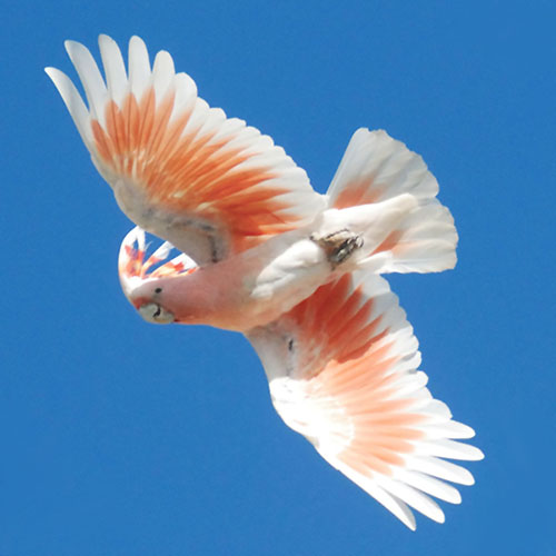
Mabi forest—a type of rainforest otherwise known as complex notophyll vine forest 5b. It is found in small patches on the Atherton Tablelands, growing on highly fertile, basalt-derived soils, and is characterised by an uneven canopy (25m-45m) with many tree layers, scattered deciduous and semi-evergreen trees, and a dense shrub and vine layer. The dense shrub layer distinguishes Mabi forest from similar rainforests, and provides important habitat for up to 114 bird species. A variety of plants and animals make their homes in Mabi forest, including the nationally threatened large-eared horseshoe bat and the spectacled flying-fox. Other species, such as the musky rat-kangaroo and the nationally endangered southern cassowary, used to occur in Mabi forest. However, the remaining patches are too small for these animals to survive in, and so the musky rat-kangaroo and the southern cassowary have become locally extinct. Before European settlement Mabi forest was inhabited by peoples of the Ngadjonji and Yidindji tribes and held deep spiritual significance for them. Mabo decision—the High Court decision in the case of Mabo v Queensland (2) 1992. The ruling gave legal recognition to the fact that Indigenous land ownership existed in Australia before European settlement, and that in some cases the Crown did not subsequently extinguish this land tenure. In its decision the High Court laid down a number of principles, which can be summarised as follows: 1) the source of native title is common law; 2) no recognition of native title by legislation is required; 3) the source of native title lies in a connection with the land and this connection; and 4) this connection must accord with traditional laws and customs. All native title determinations in Australia are now based upon the Mabo decision. Mabo v Queensland 1992—the first native title determination made in Australia, in which the High Court recognised that the Meriam people of the Torres Strait possessed native title over their traditional lands. The chief question presented to the High Court was whether or not the annexation of the Murray Islands to the Colony of Queensland had vested in the Crown absolute ownership of all land in the Murray Islands in such a way as to extinguish any pre-existing native title. The major facts of the case are as follows. Upon annexation of the Murray Islands, the Crown acquired sovereignty and the common law of England then applied to the Murray Islands. One of the rules of the common law of the time was that Crown ownership existed in the lands of an acquired territory that had no occupants, or whose occupants had no settled law (terra nullius). It is now well-documented that the Indigenous inhabitants of Australia had a subtle and elaborate system of rules adapted to the country in which they led their lives. The common-law doctrine of Crown ownership of acquired territory could not therefore apply in Australia, as Australia was not terra nullius. macadamia—Macadamia integrifolia (smooth-shelled macadamia), M. tetraphylla (rough-shelled macadamia), large, spreading evergreen trees reaching 12m-15m, with dark, shiny leaves and branches that bear long, sweet-smelling racemes of creamy white flowers. Come summer, each spray of 40-50 flowers produces 4-15 ‘nutlets’ which eventually ripen into large clusters of nut flowers. The macadamia kernel, safely stored within a hard shell, is often described as the sweetest nut Mother Nature can provide. M. integrifolia is native to south-eastern Queensland, where it grows in the rainforests and close to streams. M. tetraphylla is native to south-eastern Queensland and north-eastern New South Wales, growing in rainforests, in moist places and along stream banks. Aboriginal people have been aware of this natural treasure for thousands of years, but Europeans first discovered the wild nut trees at Mount Bauple near Maryborough in SE Queensland. It wasn't until the late 1880s, however, that serious cultivation began. The macadamia was introduced into Hawaii about 1881 where it was used as an ornamental and for reforestation. The Hawaii Agricultural Experiment Station named and introduced several promising selections in 1948, which led to the modern macadamia industry in Hawaii. The importation of improved and named varieties into California from Hawaii began about 1950. Macadamias are also commercially important in South Africa and Central America. Eventually macadamia trees, grafted from successful Hawaiian varieties, were brought to the rolling hills of north-eastern New South Wales and south-eastern Queensland, where over one third of the world's production is now grown. Most varieties of macadamia trees take approximately 10 years to reach maturity and maximum yields of nut-in-shell, but once producing continue to do so for up to 100 years. There are about 600 macadamia farms in Australia, varying in size from 200 trees to huge plantations with 50,000 trees. The macadamia nut is the only plant food native to Australia that is produced and exported in any significant quantity. macaroni—nonsense; rubbish: e.g., What he said was a lot of macaroni! Macassan—a sailor from the Indonesian archipelago in the 17th century. At that time, Makassar was capital of the Indonesian Kingdom of Gowa, the map of which included north Australia. Seasonal visits of Macassan fishermen were made to Arnhemland. The Indonesian traders sailed from Makassar and other ports on the north-west monsoon winds in late December and returned home on the south-east trade winds in April or May. They came to harvest trepang, or beche-de-mer, which they cured on site and sold to the Chinese as an aphrodisiac. Aboriginal Australians assisted in catching and preparing trepang in exchange for commodities such as knives, tobacco and rice. Macassan visits ended soon after Federation, and in 1907 the Australian government prohibited foreign fishing fleets in its territorial waters. Macassan stone pictures—commemorate the Macassan fishermen who visited north Australia annually for hundreds of years to collect trepang and trade with the Yolngu. No evidence yet exists to establish with certainty when Aboriginal trade with South East Asia began. Indonesian and Melanesian cultures influenced the art of the north coast for centuries. In style, subject matter and materials, external influences on Aboriginal art pre-date the European colonisation by centuries. This rock painting from Groote Eylandt shows a Macassan prau in full sail. The crew are lined up along the deck and on a platform in the rigging. There are two dugout canoes in the hull and a porpoise appears to have been harpooned from the stern. Macca's—McDonald's: e.g., Let's go to Macca's for burgers this arvo. MacDonnell Ranges—high relief ranges and foothills covered with spinifex hummock grassland, sparse acacia shrublands and woodlands along watercourses. Gorges, rocky clefts and waterholes repeatedly breach this rugged 400km-long barrier. For the Indigenous people these sites are imbued with spiritual ties, reflected in rock art, ceremonial places and creation stories. Located east of Alice Springs, NT. MacGillivray, John—(182 -1867) born in Aberdeen, Scotland, on 18 December 1822, died in Sydney, New South Wales, on 6 June 1867. Collected specimens in the Northern Territory and Queensland, at Port Essington, Raine Island and perhaps other localities along the Great Barrier Reef and Torres Strait during Bremer and Blackwood's Expedition in the Fly, 1838. Botanist on the voyages of H.M.S. Rattlesnake (Captain Owen Stanley, 18471850). He collected at Port Curtis, Rockingham Bay, Port Molle, Cape York, Gould Island, Lizard Island and Moreton Islands in Queensland; and in New South Wales at Port Essington and visited Sydney on several occasions. The expedition was in Hobart, Tasmania, in June 1847 and also surveyed in Bass Strait, and on the southern coast of New Guinea and the Louisiade Archipelago. He was a member of expeditions to the Fly and Bramble Rivers in 18421846, and on the voyage of the Herald (18521861). On the latter expedition, which visited Lord Howe Island, Dirk Hartog Island and Shark Bay, Western Australia, he was accompanied by William Milne. Mackay—situated on latitude 210, longitude 1480, Mackay is a vibrant tropical city, booming from the richness of sugar and mining. The area was settled in 1862 and named after Captain John Mackay, who discovered the valley of the Pioneer River. Early settlers brought sugar cane to the region and within a decade of settlement, Mackay became Queensland's largest sugar producing area, and still is. As sugar boomed so did the frontier town. Mackay's close proximity to the Great Barrier Reef and some of the world's most prized rainforests make it a holiday destination for many thousands of visitors. Located midway between Brisbane and Cairns, the Mackay region coastline stretches 200km north from St Lawrence to Laguna Whitsunday’s, and inland to the town of Clermont. Today, the community is proud of its Aboriginal, South Sea Islander and colonial heritage. The region is home to a variety of exotic wildlife such as the platypus and dugong, rare birds and butterflies. The picturesque landscape includes dramatic coastal scenery, highland waterfalls, gorges and mountains, and lush lowlands which are home to Mackay’s sugar plantations. Mackenzie bean—the trailing creeper Canavalia rosea of tropical north Australia, with an edible pod. MacKenzie Falls—flowing year-round, MacKenzie Falls is one of Victoria's largest and most spectacular waterfalls. After rain, fast-flowing water cascades over huge cliffs into a deep pool, sending fine sprays of rainbow mist high into the air above a stunning gorge. Forty minutes drive from Halls Gap on the Mount Victory Road, Victoria. Named by explorer Mitchell on the 21st of July 1836, the MacKenzie River rises in the higher reaches of the Grampians and flows north-westward through Zumsteins towards Mount Zero. Macleay's swallowtail—Graphium macleayanum, a beautiful species identified by the tails on its hind wings and the green colour on the undersides of its wings. It is commonly seen in urban Sydney from August to April. The caterpillars have adapted to feed on a variety of plants, including the introduced camphor laurel (Cinnamomum camphora). Distribution: Queensland, New South Wales, Victoria and north-eastern Tasmania. Habitat: Urban areas, forests and woodlands, heath. Status: Common. Macquarie, Colonel Lachlan—(1762-1824), colonial Governor of New South Wales, he was born in the Isle of Mull in the Hebrides islands of Scotland. He was given a mandate to restore government and discipline in the colony following the Rum Rebellion against Governor William Bligh. When he arrived in Sydney in December 1809, he found a struggling, chaotic colony which was still basically a prison camp, with barely 5000 European inhabitants. He took up his commission as governor on 1 January 1810, dismissing the New South Wales (Rum) Corps and replacing it with the 73rd regiment he had brought from England. Land grants issued during the Rum Rebellion were cancelled by Macquarie, but he later restored those that had been granted to "very deserving and Meritorious Persons". He dealt with an increase in the number of convicts sent to the colony by employing them in an ambitious program of public works and by encouraging well-behaved convicts into the wider community through tickets-of-leave. Macquarie’s ticket-of-leave policy caused conflict with a group of influential local conservatives known as "exclusives", who wanted to retain established privileges. Central to Macquarie's policy was his treatment of the emancipists: convicts whose sentences had expired or who had been given conditional or absolute pardons. By 1810 these outnumbered the free settlers, and Macquarie insisted that they be treated as social equals. Macquarie was the greatest sponsor of exploration the colony had yet seen. In 1813 he sent Blaxland, Wentworth and Lawson across the Blue Mountains, where they found the great plains of the interior. He appointed John Oxley as surveyor-general and sent him on expeditions up the coast of New South Wales and inland to find new rivers and new lands for settlement. Today, he is regarded by many as the real founder of Australia as a country, rather than as a prison camp. The nationalist school of Australian historians have treated him as a proto-nationalist hero. His grave in Mull is maintained at the expense of the National Trust of Australia and is inscribed "The Father of Australia". As well as the many geographical features named after him in his lifetime, he is commemorated by Macquarie University in Sydney, which publishes the Macquarie Dictionary. Macquarie Harbour—named after Governor Lachlan Macquarie, this 50km-long harbour, the second largest in the Southern Hemisphere, opens to the sea through the narrow, eddying waters of Hell's Gate and receives the waters of the King and Gordon rivers The spectacular entrance to Macquarie Harbour is Ocean beach, a 40km stretch that faces 8000km of the Great Southern Ocean. To the south is the Cape Sorrell lighthouse, the second highest in the Southern Hemisphere. Fish farms in the centre of the harbour produce over 9000 tonnes of fish. A coal seam runs under the water and the shores contain some of the oldest plant fossils ever found. The Harbour has a rich and dramatic convict and pioneer past. From 1822 to 1830, Sarah Island was the home of a harsh convict settlement, with logging and boat building from the locally sought Huon pine being the main trade. With the development of the silver and zinc mining fields at Zeehan in the 1890s, Macquarie Harbour became a major West Coast port. The four tribes of the Palawa people of the West Coast occupied lands adjacent to Macquarie Harbour and the women may have used Sarah Island (Langerrareroune) as a meeting place. Many present day Palawa have returned to the area. Macquarie Harbour penal station—western Tasmania was totally inaccessible by land and very difficult to reach by sea, and in 1821 these dubious assets prompted the establishment of the penal settlement on Sarah Island, in the harbour. Between 1822 to 1833 some 1150 convicts were retransported to the main settlement on Sarah Island. Its primary function was to isolate the worst of the colony's convicts and then use their muscle to harvest the huge stands of Huon pine. The convicts worked upriver 12 hours a day, often in leg irons, felling the pines and rafting them back to the island's saw-pits where they were used to build ships and furniture. With its barbaric treatment of prisoners, Sarah Island became one of Australia's most notorious penal settlements. The most dreaded punishment was confinement on tiny Grummel Island, where up to 40 convicts at a time were held in appalling conditions on what was little more than a windswept rock—for some, death was a welcome release. Macquarie Harbour vine—the twining plant Muehlenbeckia gunnii, mainly of Tasmania, having an edible fruit. Macquarie Island—the exposed crest of the undersea Macquarie Ridge, raised to its present position where the Indo-Australian tectonic plate meets the Pacific plate. The southern part of Macquarie Island is composed of rocks that are typical of those currently forming along mid-oceanic ridges. These ridges occur on the ocean bed, where lava erupts out of long fissures running for hundreds of thousands of kilometres across the major ocean floors. The northern part of Macquarie Island is formed mainly of intrusive igneous rocks, whereas the remainder is formed mainly of extrusive volcanic rocks and associated sedimentary rocks. Despite the eroding effects of the very strong winds and huge waves that are generated in the vast Southern Ocean, the island is now some 200m—400m high. The date at which Macquarie Island broke through the sea surface is currently being debated by geologists. Some suggest 700,000 years ago while others think that it could be from 80,000 to 300,000 years ago. Macquarie Island is one of Australia’s sub-Antarctic islands, located midway between Tasmania and Antarctica in the Southern Ocean. Macquarie Island Meteorological Station—located on Macquarie Island, 1280km south-east of Hobart and 1440km from the Antarctic coast. It is one of Australia’s four weather outposts in this inhospitable region. Macquarie Island World Heritage Area—one of Australia's most distant possessions. Located in the Southern Ocean, Macquarie Island is actually 200km closer to the Antarctic continent than its parent state of Tasmania, which lies 1500km to the north-west. Measuring an area of 128sq km, the island is 34km long by just 5km at its widest point. In 1996 Macquarie Island was nominated by the Australian government for inscription on the World Heritage Register, mainly for its unique geological features. The island is the exposed crest of the undersea Macquarie Ridge, raised to its present position where the Indo-Australian tectonic plate meets the Pacific plate. The southern part of the Island is composed of rocks that are typical of those currently forming along mid-oceanic ridges, which contribute directly to the process of continental drift. The site also provides geological evidence for sea-floor spreading, and is an exposure of the oceanic plate boundary between the Pacific and Indo-Australian plates, with active faults and ongoing tectonic movements. It is the only place on earth where rocks from the earth's mantle (6km below the ocean floor) are being actively exposed above sea level. These unique exposures include excellent examples of pillow basalts and other extrusive rocks. For over 50 years, Australia has operated a research and Antarctic support station at the northern end of the island. The station (built in 1948) is home to over 40 people over the summer and around 20 through winter. Macquarie Marshes—located on the lower Macquarie River near Warren, NSW, the wetland comprises a complex of braided swamps, channels and gilgai floodplain, inundated by flooding from the lower Macquarie River and its effluents and anabranches. Some flooding occurs in most years, but the Macquarie River is a regulated system, and the magnitude and frequency of flooding have been reduced. The vegetation consists of extensive areas of reeds and woodlands of river red gum, with limited areas of lignum. Marginal areas have woodlands of coolibah and black box. Following flooding, there is widespread breeding of many species of waterbirds involving 42 species. The Macquarie Marshes provide drought refuge when wetlands in other parts of the state, especially more inland areas, are dry. They also provide habitat for a substantial fauna of reptiles that are either aquatic or strongly associated with water. The nature reserve area is already listed as a Ramsar wetland, and the remainder of the marshes are proposed for listing. Macquarie perch—the freshwater fish Macquaria australasica of rivers in SE Australia, valued as food. Macquarie Ridge—the mid-oceanic ridge from which Macquarie Island originated. The Macquarie Ridge appeared above sea level just over half a million years ago. When it had risen more than 2.5km from the sea floor, it broke through the ocean surface to become Macquarie Island. Maps of the earthquake epicentres show a series of quakes following the line of the Macquarie Ridge from New Zealand to its junction with the Antarctic Plate, and it can be expected that there will be an earthquake greater than magnitude 7 every ten years. The analysis of earthquake data since 1964 indicates that some of the events are very shallow and that the foci of the major earthquakes are under the Macquarie Ridge. Macquarie River—one of the main inland rivers in New South Wales. It headwaters rise in the central highlands of NSW near the town of Oberon. The river travels generally northwest past the towns of Bathurst, Wellington, Dubbo and Warren to the Macquarie Marshes and the Barwon River. Burrendong Dam is a large dam near Wellington which impounds the waters of the Macquarie River and its tributary the Cudgegong River for flood control and irrigation. The upper reaches of the Macquarie River were first discovered by European settlers in 1813 and the river was named for the then Governor of New South Wales, Lachlan Macquarie. Macquarie River catchment—situated in Tasmania's Midlands, which is the second oldest agricultural region in Australia. The Macquarie River catchment has an area of approximately 3860sq km, and the major tributaries are the Elizabeth, Lake, Isis and Blackman Rivers. The region is one of relatively low rainfall, with the annual rainfall ranging from below 500mm in the lowlands to more than 900mm in the headwaters of the catchment. The Macquarie River catchment is characterized by dolerite in the upper catchments and sandy soils and alluvium in the valley floors. There are also small basalt outflows and areas of sandstone and mudstone. Almost two hundred years of pastoral and agricultural activities and settlement has transformed much of this region. The original grasslands, grassy woodlands, open forests and wetlands are now a mixture of cereals, introduced pastures and remnants of native vegetation. Much of the native vegetation is threatened and is severely depleted in its range. Within this matrix are localities of high biological significance that are often small, fragmented and may be highly modified. There are populations of threatened plant and animal species, some of which are confined to the catchment. Macquarie River Valley—the area is a bedrock-confined alluvial valley, extending from Burrendong Dam to Narromine, at the margin of the highlands and the Darling Riverine Plain. The catchment is formed of Palaeozoic rocks of the Lachlan Fold Belt south-east of Wellington and Mesozoic sediments of the Oxley Basin to the north and north-west as far as Narromine. Mid-Miocene basalt flows overlying alluvial gravels are found within the area at Mookerawa and Brocklehurst. Three stratigraphic units can be identified: 1. the basal Late Miocene – Early Pliocene clays and sand; 2. the Pliocene gravels and sands; and 3. the surface Quaternary sandy clays and clay (downstream). The vegetation, reconstructed from palynology, was initially wet sclerophyll, changing to rainforest with increasing precipitation. macropod—any plant-eating mammal of the family Macropodidae, native to Australia and New Guinea, including kangaroos and wallabies. macropoid marsupial—(see: macropod). Macropus—a marsupial genus that belongs to the family Macropodidae. It has 13 species which are further divided into 3 subgenera. The genus includes all terrestrial kangaroos, wallaroos and several species of wallaby. The term itself is derived from the Ancient Greek makros "long" and pous "foot". A further 11 extinct species are recognised. The type species is the eastern grey kangaroo. Macropus pearsoni—is an extinct Australian vertebrate species belonging to the family Macropodidae, and the same genus Macropus as extant kangaroos. M. pearsoni lived during the Pleistocene. It is known from fossil mandibles collected from Pleistocene beds from the Darling Downs in New South Wales, Lake Kanunka in north-eastern South Australia, and Cape York Peninsula. Macropus rama—a kangaroo species species known from fossil remains at King Creek, Pilton, Queensland, of Late Pleistocene age ( Bartholomai, 1975). Common name: mountain kangaroo. mad as a cut snake—1. crazy; insane; stupid; foolish; demented; unbalanced. 2. very angry. mad as a gumtree full of galahs—1. crazy; insane. 2. silly; foolish; eccentric; odd; queer. mad as a meat axe—extremely angry. mad if you don't!—expression of encouragement. mad keen—extremely eager. Madam Muck—an affected woman who puts on airs and graces far above her social standing. made a hole in it—to have got work well under way, started: e.g., We tried to clear the land manually at first, but the bulldozer has really made a hole in it. Madigan, Dr Cecil—an explorer, geographer and scientist. In 1939 he organised an expedition, by camel, across the area to the north of Lake Eyre, now known as the Simpson Desert. They were to cross the Dead Heart from Andado Station to Birdsville and then south to Lake Eyre and Marree. It took them 25 days to reach Birdsville. The Simpson Desert was first crossed in 1939 by Dr. Cecil Thomas Madigan who travelled the sandy dunes from west to the east. Madigan named the barren desert after the President of the South Australian branch of the Royal Geographic Society which had sponsored his trip. Madigan made observations on his journey, noting that he crossed 754 sand dunes between the Finke River and Birdsville. This is a distance of around 370km, indicating the rate of travel capable in such conditions. At times there was great anxiety over food and water supplies, for themselves and the camels. Ironically, some delays were experienced from rain, which made loading camels unwise and, later, water around Lake Eyre made some crossings of usually dry river beds hazardous for camels. Marree was reached on day 51. mado—Atypichthys mado has a silver body with dark brown-to-black stripes, yellow fins, large eyes, a small mouth and a forked tail, and grows to 25cm in length. It is found on coastal and estuarine reefs and is one of the most common species in New South Wales and has been recorded from southern Queensland to eastern Tasmania. The Australian mado looks very similar to the New Zealand mado but differs in colouration and fin ray counts. Maduwangka—Aboriginal people of the Kalgoorlie area, Western Australia. Magela Creek—a small tributary to the East Alligator River. The creek lies in a shallow valley and is flanked by alluvial deposits that were anciently formed into terraces. With each ice age and associated fall in sea level, distinct channels were incised into the valley. maggies—magpies. magistrate—1. a civil officer administering the law. 2. an official conducting a court for minor cases and preliminary hearings. magistrate's court—a court for minor cases and preliminary hearings. Magnetic Island—half of the island (approximately 5184ha) is national parkland. Twenty-four kilometres of tracks guide visitors through thickly wooded bushland, ranging from dry wattles and stunted eucalypts to moist, forested valleys. Many lookouts provide views of sandy beaches and coral-fringed bays separated by boulder-strewn headlands. The island is home to koalas, rock wallabies, brush-tail possums and an abundance of birds. Located 8km from Townsville, Queensland. magnetic termite—Amitermes meridionalis, is adapted to living on floodplains with waterlogged soil in the Darwin area of the Northern Territory. The termites cannot migrate above and below ground to regulate their temperature during the hot tropical summer Recent studies confirm the presence of biogenic ferrimagnets (magnetite?). When the Wet season begins the termites live in their mound. When it is the Dry season, they live below the ground. magnetic termite mounds—built by magnetic termites, the mounds are like enormous magnetic compasses with their thin edges pointing north to south and broad backs east to west, minimising their exposure to the sun and thereby keeping the mounds cool for the termites inside. These mounds average 2.5 meters tall and are very common in the Darwin area, NT. magnificent riflebird—P. magnificus, 28cm—33cm long, with males larger than females. They are the largest of the Australian species. The male has the metallic greens, purples and blues extending further down the breast than in the other two species (paradise riflebird and Victoria's riflebird) and has wispy plumes along its flanks. The female is more reddish above and has regular, fine, black barring on the underparts. The call is a loud, whistling weeeo. The magnificent riflebird is found in the northern-most tip of the Cape York Peninsula, as well as in New Guinea. magnificent tree frog—Litoria splendida, one of the larger species of tree frogs, well known and a common visitor to human dwellings. Found in caves, rock crevices and buildings in the Kimberley (except the west) and in the Northern Territory. Also known as magnificent green tree frog, Australian green tree frog. magpie—1. Gymnorhina tibicen, a medium-sized bird easily recognised by its black and white colouring. Adult males in Western Australia have a pure white back. The powerful and relatively long bills are greyish-white with a black tip. The eye is reddish-brown and the feet are black. It feeds mainly on small insects and other animals that live in or just under the ground, such as worms, beetles, ants, spiders, frogs, lizards and even carrion. Magpies form two main associations—tribes and flocks. Tribes consist of two to 10 birds of both sexes, which occupy a territory of up to eight hectares. They vigorously defend this breeding and feeding area against other magpies. Flocks consist of young adults and older birds unable to form a tribe or gain access to a territory. Magpies prefer to nest in tall trees. During the nesting season between August and October, after the chicks have hatched, both male and female magpies often vigorously defend the nest by swooping and diving at potential intruders. Care should be taken not to approach nest sites during this short period. They have adapted successfully to urban and agricultural areas. The loud, flute-like carolling call is a feature of our bushland and gardens. Like willie wagtails, magpies can sometimes be heard on bright moonlit nights. A relish for eating many harmful insect pests and the bird's bold nature have made the magpie popular with the suburban gardener and other bird lovers. Australian magpies are often found in relatively open gardens, and sometimes become quite tame in suburban areas. Also known as western magpie, kulbardi (Nyoongar name). 2. an idle chatterer. 3. a person who collects things indiscriminately. magpie goose—Anseranus semipalmata relies on two main habitat types and two main food plants. During the breeding season, the adults frequent patchy grass and sedgelands where they and their young graze on the seeds of wild rice. As these areas begin to dry out, the geese move to swamps where water chestnuts grow. From July to September the geese shuffle through the sticky mud, digging up the tubers with their hooked bills and gorging on this high-energy food. As the wetlands dry out, the geese congregate in ever-increasing numbers on the remaining swamps. The late dry season is a lean period, but when the rains come the birds are able to feed on young shoots of grass until the next crop of wild rice seeds is ready. Magpie geese were once widespread across Australia but alterations to wetlands, poisoning and shooting have led to their disappearance in southern, temperate areas. Magpie geese now occur only in the tropical savannahs of northern Australia. The magpie goose is a very important part of the lives of Aboriginal people across northern Australia. These birds are abundant on wetlands. They are hunted as a source of food and eggs are harvested from their nests in swamps. Magpie geese nest during the wet season and the eggs are ready to be collected in the middle of the wet, in February. Traditional practice prohibits pregnant women from eating goose eggs. magpie-lark—Grallina cyanoleuca, a conspicuous Australian bird of small to medium size. It had been relegated to a subfamily of fantails in the family Dicruridae (drongos), but has been placed in a new family of Monarchidae (monarch flycatchers) since 2008. It is a common and very widespread bird both in urban and rural areas, occupying all parts of Australia except for Tasmania and some of the inland desert in the far north-west of Western Australia, and appears to have adapted well to the presence of humans. The magpie-lark was originally described by English ornithologist John Latham in 1802. Like many Australian birds, it was named for its apparent similarity to the northern hemisphere birds familiar to European settlers. In fact, it is neither a magpie nor a lark and is not particularly closely related to either. It has many common names, including peewit, peewee, mudlark (in Victoria), and Murray magpie. It was known as Yilimbirraa among the Yindjibarndi people of the central and western Pilbara. Around 26-30cm long when fully grown and boldly pied in black and white, they are a familiar sight around the country. The sexes are similar from a distance but easy to tell apart: the female has a white throat, the male a black throat and a white "eyebrow". Juveniles and immatures of either sex have the white throat of the female and the black eyestripe of the male, and a white belly also accompanies. A primarily carnivorous species that eats all sorts of small creatures, the magpie-lark can adapt to an enormous range of different habitats, requiring only some soft, bare ground for foraging, a supply of mud for making a nest, and a tree to make it in. Group gatherings of magpie larks have been observed, with loose "flocks" comprising dozens of individuals being observed perched on vantage points. The Magpie-lark is aggressively territorial, and will fearlessly defend its territory against larger species such as magpies, ravens, kookaburras, and even the wedge-tailed eagle. Birds generally pair for life (though divorce is not unknown) and defend a territory together. The nest is round, about 150mm in diameter with vertical sides, made of grass and plant material thickly plastered together with mud and generously lined with grass, feathers and fur, and is usually placed on a flat branch somewhere near water. Breeding is opportunistic, usually from August to February in the fertile south, any time after rain in drier areas, and multiple broods are common when conditions allow. Duet singing magpie-larks are one of the 200-odd species of bird around the world that are known to sing in duet; each partner producing about one note a second, but a half-second apart, so that humans find it difficult to tell that there are actually two birds singing, not one. The duet singing is now known to be cooperative: pairs sing together to defend their territory. Magpie-larks sing more vigorously in response to duet calls from other birds than they do to the call of a single rival, and more vigorously still if the callers are strangers rather than established and familiar birds from a neighbouring territory. magpies—1. a name for South Australians during colonial times. 2. (hist.) convicts, a reference to the parti-coloured uniform issued as a mark of disgrace. magsman—1. a confidence trickster. 2. a raconteur. mahogany glider—Petaurus gracilis, a nocturnal, possum-like marsupial which is able to glide from tree to tree using skin flaps stretched out between its legs. It carries a formidable set of claws, which it needs to climb trunks for take-off and to grasp onto its landing sites and. Its diet consists largely of nectar and sap from flowering trees and so it needs a large and diverse home range to provide food all year round. This diet is supplemented by pollen, fruit, arthropods, arachnids, wattle exudates and honeydew. Their habitat usually includes areas of Melaleuca Forest and specialised Eucalypt and Acacia swampland communities. The female and her young need perhaps 30 hectares of forest to survive, and will rest during the day in one of perhaps a dozen hollow tree nests distributed on a seasonal circuit. The mahogany glider is officially recognised as an endangered species and was in fact considered extinct until it was rediscovered in 1989. Its habitat extends from Hull River in the north to Crystal Creek in the south—an area of approximately 720sq km in the lowland Wet Tropics of north Queensland. This habitat is now extremely fragmented by agricultural development. maiden—(cricket) over. maiden over—(cricket) an over in which no runs are scored off the bat. maiden's blush—the small rainforest tree Sloanea australis. mail—information; facts: e.g., I'll give you the mail—that new horse is a winner! Main Range National Park—a succession of impressive peaks, escarpments, and ridges to the south-west of Brisbane. Comprising rainforest and open forest, the 18,400ha park straddles the Great Dividing Range on the Scenic Rim. The park extends from Mount Mistake in the north to Wilson’s Peak on the Queensland-New South Wales border, and west to Queen Mary Falls. The park is made up of four sections: Mount Mistake, Cunningham’s Gap including Spicer’s Gap, Mount Roberts, and Queen Mary Falls. Declared in 1909, it was one of Queensland’s first national parks. Main Range National Park is a recreational, rainforest retreat for walkers, wildlife watchers, and campers. Maitland Bay—located at the heart of the 300ha Marine Extension to Bouddi National Park, the bay was named for a steamer that sank in there 1898. Major Mitchell cockatoo—Cacatua leadbeateri, a pink and white, medium-sized cockatoo restricted to arid and semi-arid inland areas of Australia. With its soft-textured white and salmon-pink plumage and large, bright red and yellow crest, it is generally recognised as the most beautiful of all cockatoos. It is named in honour of Major Sir Thomas Mitchell, who wrote "Few birds more enliven the monotonous hues of the Australian forest than this beautiful species whose pink-coloured wings and flowing crest might have embellished the air of a more voluptuous region". Unlike the galah, Major Mitchell's cockatoo has declined rather than increased as a result of man-made changes to the arid interior of Australia. Where galahs readily occupy cleared and part-cleared land, Major Mitchell's cockatoo requires extensive woodlands, particularly favouring Callitris, Allocasuarina and Eucalyptus. In contrast to other cockatoos, Major Mitchell pairs will not nest close to one another; in consequence, they cannot tolerate fragmented, partly-cleared habitats, and their range is contracting. Molecular analysis published in 1999 suggests that the original placement of this species in a monotypic genus, Lophocroa is valid. Also known as: Leadbeater's cockatoo, pink cockatoo, desert cockatoo, chockalott, wee juggler. make a blue—make a glaring error or mistake. make a botch of—mess up; ruin, spoil. make a go of—try to succeed at: e.g., They're trying to make a go of their marriage for the second time. make a good fist of—do something exceptionally well. make a good job of—1. (something) to complete satisfactorily; do well. 2. (someone) bash, beat, physically assault. make a hash of—ruin, spoil, bungle (something); mess up. make a muck of—spoil, ruin, bungle, make a mess of (something). make a proper galah of (oneself)—make a complete fool of (oneself). make a quid—1. earn a living: e.g., What does he do to make a quid? 2. make a lot of money; become wealthy. make a rod for (one's) back—cause, create a difficulty, problem, burden for (oneself). make a welter of—create confusion, disorder in the process of doing something; over-indulge to excess. make an arse of (oneself)—make a fool of (oneself). make custard out of (someone)—defeat, beat (someone) soundly, either physically or as in a contest. make heavy weather of—do something the hard way, find something unnecessarily fraught with problems and difficulty. make it hot for (someone)—create trouble for (someone); make life difficult and unpleasant for (someone). make like a boong's armpit/tree (and leave)—depart; leave; go. make mincemeat out of (someone)—1. beat, bash, hit, physically assault (someone). 2. berate, verbally attack, criticise (someone) with success. make no odds—make no difference; be of no importance; not to matter: e.g., It makes no odds with me which way we go as long as we get there. make (one's) alley good—improve (one's) prospects of success, especially (of a man) with a woman; make the grade. make redundant—lay off (employee) as no longer needed. make sheep's eyes at (someone)—give (someone) amorous, adoring looks, glances. make wages—earn an adequate living. make with the—hand over; give; pass; prepare; offer: e.g., Make with the munchies, I'm starving! mala—1. (cap.) Aboriginal tribe of the Kakadu area, Northern Territory. 2. (see: rufous hare-wallaby). Malanda—a quiet town located about 25km south-east of Atherton. It resides in one of the wettest areas of the Atherton Tablelands, and hence is surrounded by pockets of rainforest and rolling hills covered with lush, green grass. Freshwater creeks snake their way through this region, culminating in waterfalls that cascade into refreshing swimming holes. The principle reason for Malanda’s existence is the Tropical North Queensland dairy industry. One of the world’s largest dairy factories provides the main source of employment here, and is supported by over 190 local dairy farmers. The dairy products sourced from this town travel along the longest milk run in the world, reaching south to Townsville, west to Alice Springs, north to Darwin and overseas to New Guinea and South East Asia. malarkey—nonsense; rubbish; foolish talk. Malintji—also known as Maiawali, an Aboriginal tribe of Queensland. Mallacoota—Victoria's most isolated fishing port. The area was settled when both Ben Boyd and the Imlay brothers, who were whaling along the coast from southern NSW to northern Victoria, established the Mallacoota Inlet as their major station south of Twofold Bay. By the 1880s settlers had moved into the area and commercial fishing had begun, with boats being moored in the Mallacoota Inlet. At this time it was common for fishing boats from further down the coast to fish the inlet for salmon and bream, which was shipped around the coast to Melbourne. This industry was disrupted in 1894 when gold was discovered in the district. The Spotted Dog Mine (reputedly named after a spotted dog that was killed by a falling tree) was operational for three years. Mallacoota is located close to the New South Wales border, at the end of Croajingolong National Park. Mallacoota Inlet—two interconnected main lakes. These are referred to as the top lake and the bottom (seaward) lake. The top lake is closed to commercial fishing. Abalone diving is the major fishery in Mallacoota. The opening to the inlet closes periodically due to a buildup of ocean sand. In 1994 when a sand bar closed the inlet entrance lots of algae grew due to the warmer water temperatures, resulting in a small fish kill in the top lake. mallee—1. a stunted, multi-stemmed growth habit with a lignotuberous root mass. This is the natural the growth form of many eucalypts, particularly in dry areas with infertile soils. Mallee growth forms can be found in some gum species in areas far from the 'mallee' country of the inland but southern portion of the country (such as in Lamington National Park in SE Queensland). 2. (the Mallee) the ecosystems characteristic of inland Australia, dominated by eucalypts—especially in Victoria, the principal natural vegetation of which is mallee scrub. 3. any remote, isolated scrub or bush land: e.g., He lives out in the mallee somewhere. mallee and saltbush scrub—mallee are stunted eucalypts adapted to fire and drought, growing from tubers. Saltbush is dominant in scrub country and on the margins of the deserts. Common fauna include red kangaroo, grey kangaroo and emu. Common in South Australia. Mallee bioregion—recently re-defined to include an area from the Coolgardie bioregion—the area between Lake Hope, Forrestiana and Mount Holland, which comprises salmon gum and morrell woodlands on greenstone, with smaller areas of mallee and acacia / casuarina thicket on sandplains. The south-eastern part of Yilgarn Craton is gently undulating, with partially occluded drainage. Mainly mallee over myrtaceous-proteaceous heaths on duplex (sand over clay) soils. Melaleuca shrublands characterise alluvia, and samphire low shrublands occur on saline alluvium. A mosaic of mixed eucalypt woodlands and mallee occur on calcareous earth plains and sandplains overlying Eocene limestone strata in the east. Semi-arid warm Mediterranean. Extensively cleared for agriculture. mallee gate—a makeshift gate. mallee heath—develops on deep, siliceous sands associated with relatively recent dune formation in areas receiving less than 350mm rain per annum. Organic matter is low and soil structure is poor and subject to drought stress. The structure is variable, although the overstorey, where present, is usually dominated by short trees, such as yellow mallee, slender-leaf mallee, Dumosa mallee and desert stringybark. The understorey is dominated by heathy shrubs, such as desert banksia, green tea-tree, scrub she-oak, scrub cypress pine and myrtle, with few if any grasses except for common porcupine grass. Large, contiguous and high-quality examples of this vegetation type occur throughout the Little Desert National Park. mallee ringneck—Barnardius barnardi barnardi, a ringneck parrot found in eucalypt, mulga and Callitris woodland east and north-east of the Flinders Ranges, to about Windorah in Queensland. Length: 32cm—34cm. Blue-green; green dominates. Darker on breast, more yellowish on division of breast and belly. Dark green on back, green on rump; upper tail coverts are edged in blue. Heavy brownish forehead; yellow neck ring. Wing curve blue; underneath the tail green-blue. Bluish-green on throat. Eyes brown, beak light gray, legs gray. The female has a smaller head and bill, and her markings are not as sharp. After 12 months the young achieve adult coloring. Also known as Barnard's parrakeet. mallee roller—a heavy roller used to crush mallee. mallee scrub—semi-arid eucalypt woodland of mainland Australia, especially in north-east Victoria. Communities of dwarfed, multi-stemmed, long-lived eucalypts growing on sand dune systems survive bushfires and droughts by re-sprouting from large underground lignotubers. The deeper sands are dominated by heathlands of desert banksia, scrub-pine and desert she-oak. In the more saline, older dune systems, succulent saltbushes grow under the mallee. Where the saline groundwater intersects the surface, permanent saltpans are dotted between plains of spear-grasses and low rises of slender cypress-pine woodland. Living within the mallee scrub are many species of reptiles and a distinctive range of birds. Parrots are also prominent, including the colourful mallee ringneck, pink cockatoo and regent parrot. mallee-broombush—Melaleuca uncinata, also known as broom honey-myrtle, is distributed widely in mallee areas of Western Australia, South Australia, Victoria and New South Wales, with outlying pockets occurring in Queensland. It occurs as a dominant shrub or sub-dominant under mallee eucalypts. Typically, broom occurs in discrete patches with various other mallee types interspersed. In some areas the patches are abrupt while in others there is a gradual transition between vegetative types such that broombush may occur as a minor component of other vegetation associations. malleefowl—Leipoa ocellata, one of only two mound-building birds in Australia. Large and sedentary, the malleefowl mate for life, yet are usually solitary. The male is bound to maintenance of the nesting mound and the female wanders in search of the food necessary to sustain its heavy egg production. The male builds a large mound and monitors its temperature with his bill and tongue. To build the mound, the male first digs a hole in the ground 3m—4m in diameter and 1m deep. Into the hole he sweeps a large quantity of dry leaves and twigs from a radius of up to 25m, forming a mound that is more or less level with the original surface. He then digs an egg chamber about 500mm wide and 500mm deep in the top of the mound. When rain has wet the vegetable material, the bird covers the whole mound with sand, and the result is perhaps 5m in diameter and 1.5m high. Inside it, eggs are incubated by the heat generated from decaying vegetable matter and by the heat of the sun. The chick must struggle up through a metre of loose sand to the surface of the mound. Within 24 hours it can fly, for although its body is downy at hatching, its wings have feathers. Throughout the breeding season, the male defends the area immediately surrounding the mound, so the pair are seldom seen together away from the mound. The name "mallee" comes from the main district where they are found (North East Victoria), which is also the name to describe the region. These birds do not need to drink from surface water. They feed on seeds (acacia & cassia shrubs), herbs, blossoms and insects such as cockroaches and beetles. Maloga Mission-Cummeragunga Reserve—in Moira, Yorta Yorta and Ulupna country. In 1874, Maloga Mission was established by Daniel and Janet Mathews "to feed, clothe and teach as though they were our own children" the Aboriginal children from the Barmah area in Victoria. In 1883, Cummeragunga Reserve was established in New South Wales, on the other side of the river to Barmah, and in 1888, the people were moved from Maloga Mission to the new site, six kilometres away. In 1939, the people walked off the mission in protest of the way they were treated by the manager. In 1953, Cummeragunga was closed as a station and reduced to reserve status. In 1965, the company, Cummeragunga Pty Ltd was registered. Today, many Koorie families reside on Cummeragunga. However, the children attend primary school at either Moama in New South Wales, or at Picola in Victoria, and secondary school in Echuca or Nathalia. mala—the person in charge; the boss. Maluridae—a family of small, insectivouous passerine birds endemic to Australia and New Guinea. Commonly known as wrens, they are unrelated to the true wrens of the Northern Hemisphere. The family includes 14 species of fairy-wren, 3 emu-wrens, and 10 grasswrens. In the late 1960s morphological studies began to suggest that the Australo-Papuan fairy-wrens, the grasswrens, emu-wrens and two monotypic wren-like genera from New Guinea were related and, following Charles Sibley's pioneering work on egg-white proteins in the mid-1970s, Australian researchers introduced the family name Maluridae in 1975. The Maluridae are one of the many families to have emerged from the great corvid radiation in Australasia. Their closest relatives are the Meliphagidae (honeyeaters), the Pardalotidae, and the Petroicidae (Australian robins). Their obvious similarity to the wrens of Europe and America is not genetic, but simply the consequence of convergent evolution between more-or-less unrelated species that share the same ecological niche. Malyangaba—an Aboriginal people of the border area between New South Wales and South Australia. Mammoth Cave—located 21km south of Margaret River and 33km north of Augusta, Western Australia. An easily accessible site revealing prehistoric fossil remains from over 35,000 years ago. This Mammoth Cave—there are others of the same name—was opened to the public in 1904. The carefully orchestrated experience begins with a walk trail, leading visitors along a boardwalk that crosses over the Mammoth Stream to the entrance of the cave. From here, it is a self-guided experience, aided by a state-of-the-art, CD headset. A guide is stationed outside the cave to inform and interpret the environment. The Mammoth Cave Tour takes approximately one hour. Tickets are purchased at the cave’s entrance, from CaveWorks, or from the Margaret River Tourist Bureau.
|