| Search JoyZine with Google Site Search! |
Australia Decoded
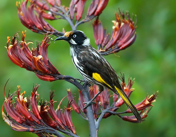
NB—nota bene; note well, take note. NBG—no bloody good. near at hand—close by. near go—a narrow escape. near sighted—short sighted. near to the bone/knuckle—indecent; improper; lewd. Nearie Lake Nature Reserve—a 4,347ha park in New South Wales, created in 1973 The reserve is dominated by chenopod shrublands, while the lower flooding areas support black box, lignum and old man salt bush. Sandy ridges support belah-western rosewood woodlands. Western grey kangaroo, common wallaroo and red kangaroo have been recorded in the park, as well as a wide array of birds. nebbie—Nembutol sleeping pill. nebraska—toilet. neck (someone)—1. reprimand (someone) severely. 2. wound superficially, as with a bullet. neck or nothing—risking everything on success. neckful—enough to try one's patience: e.g., I've had a neckful of her complaining. necktie—hangman's noose. nectars grevillea—nectar-bearing flowers such as bottlebrush, grevillea, banksia, hakea and the grass tree were sucked by Aboriginal people for their sweet nectar. By immersing the flowers in water a sweet-tasting drink was made, often when the dew was still on the grass and plants. Blossoms of some plants were collected and kneaded in a coolamon. The flowers are then removed and water mixed with the residue to make a sweet drink. ned 'em—to throw two heads in the game of two-up. neddies—horses, especially in reference to racing: e.g., I like to have a flutter on the neddies sometimes. need (something) like a dog needs a flogging—need, want, desire (something) urgently, very much. needle game/match—a contest that is very close or arouses personal grudges. neg driving—negligent driving. negative gearing—a plan under which the interest payments on the borrowing for an investment exceed the net revenue from the investment, the loss being set against other sources of income to reduce the tax liability. nellie/nelly—cheap red wine. Nellie Bligh—(rhyming slang) fly or eye. Nelson—a fishing village located at the mouth of the Glenelg River, in the south-western corner of Victoria. Major Mitchell explored the area during his Australia Felix expedition of 1836. His party were the first Europeans to investigate the Glenelg River. The town was named after the survey ship, the Lady Nelson, which was used by Lieutenant Grant to explore the southern coastline at the very start of the 19th century. Nelson is located 433km west of Melbourne and a couple of kilometres from the South Australian border. Nepabunna Community Incorporated—an Aboriginal Corporation and a local governing body which is situated on Adnyamathanha land in the remote north-east area of South Australia. Also known as Nepabunna Community Council. Nepean Peninsula—a sandy bar separating Bass Strait and Port Phillip Bay, on the tip of the Mornington Peninsula. Included in the area are the townships of Sorrento, Portsea and Blairgowrie. The thick tea-tree forest which covers the Nepean Peninsula today is re-growth following the destruction of the native she-oak used to fuel the lime kilns built in the early part of the last century. Regionally important animal species within this remote and protected area include the white-footed dunnart, long-nosed bandicoot, black wallaby, singing honeyeater, spiny-cheeked honeyeater, blue-winged parrot and hooded plover. The Nepean Peninsula forms one side of Port Phillips Heads. Nepean River—with a total length of 145km, the Nepean is part of the Hawkesbury River system in New South Wales. It rises in the uplands west of Wollongong and flows northward to its junction with the Warragamba River near Wallacia, where it becomes part of the main Hawkesbury stream. It retains the name of Nepean until it meets the Grose River where the Hawkesbury proper begins. Before European settlement the river was a major source of food for Aborigines, who caught fish in its waters and dug for native yams along its banks. In the early years of the colony the Nepean/Hawkesbury Valley was known as "the granary of the colony". In addition, it provided a way by which trade could be carried on with Sydney and a means by which produce was carried to market. Today, about 3500 hectares are irrigated along the Nepean River to meet agricultural needs. The Upper Nepean catchment area contains the Nepean, Avon, Cordeaux and Cataract dams, and supplies the majority of Sydney's water. nervous as a long-tailed cat in a room of rocking chairs—very nervous, anxious. netball—a game similar to basketball, played mostly by women, and the most popular women's participation sport in Australia. Neumeyer, Georg Balthazar von—a magnetician and meteorologist born 21 June 1826, Germany; died: 24 May 1909. Von Neumeyer, a Bavarian Ship's Officer who had obtained his doctorate at Munich in 1849, first arrived in Melbourne in 1852. Convinced of the importance of meteorology, he returned to Europe in 1854 and obtained the instruments necessary to establish the Flagstaff Observatory in Melbourne in 1858. Initially working as a private citizen, he established a number of observing stations throughout Victoria, mainly at lighthouses. In 1859, he was appointed as Government Astronomer. He completed a detailed magnetic survey of Victoria, 1858-1864. And he gradually built up the observatory recruiting, inter alia, W. J. Wills who was subsequently to perish in the ill-fated Burke and Wills expedition. Neumeyer played a leading role in the early scientific life of Melbourne before returning to Europe in 1863. never know (one's) luck in the big city—expression of encouragement stressing the possibility of success and fortune in some enterprise, especially in the city. never-never land—1. any remote, sparsely populated place: e.g., He grew tired of life in the city and now lives out in the middle of never-never somewhere. 2. imaginary: e.g., never-never land. New Australia—(hist.) a socialist utopian settlement in Paraguay in 1893, formed by members of the New Australia Cooperative Settlement Association. New Australian—1. (hist.) a colonist of New Australia. 2. an immigrant to Australia, especially one's whose first language is not English. new broom sweeps clean—new people, employees, bosses etc revitalise and inject enthusiasm into a project etc, rid an organisation of corruption. new chum—1. newly arrived British immigrant. 2. novice; beginner. New England—situated on the Great Dividing Range throughout the northern part of New South Wales to the Queensland border. The region is a rich agricultural area and one of Australia's prime wool-producing areas, and contains many national parks. It is also home to the Southern Hemisphere's largest granite monolith. Indeed, granite is unquestionably the dominant rock formation in the area. New England Fold Belt—the youngest structural feature in New South Wales, separated from the Lachlan Fold Belt by the Sydney-Bowen Basin. The oldest rocks in the sequence are Devonian sedimentary and volcanic rocks, formed in an island arc environment. The youngest are Triassic sandstones and shales deposited by rivers on the edge of the Gunnedah Basin, about 250 million years ago, at a time when New England was being lifted by intrusions of granite. New England Highway—a speedy inland route between Sydney and Brisbane. However, the coastal road passes through one of the most historic and picturesque areas of New South Wales. New England Range—(see: New England Tablelands). New England Tablelands—a bioregion of stepped plateau, hills, and plains with elevations between 600 and 1500m. The eastern edge of the bioregion is at the Great Escarpment, where coastal streams have cut deep gorges below the plateau. It is Australia's largest plateau, having 23,000sq km above an elevation of 900m, the loftiest point being Round Mountain. The plateau is predominantly granite, although to the east there is softer rock. The granite country is steep, with abundant boulder outcrops and rounded tors. The basalt country is more planar, except around former eruption centres that form high peaks, and the individual basalt flows are seen as distinct levels across the plains. The major centres of the New England region include: Armidale, Tamworth, Glen Innes, Tenterfield, Inverell, Moree, Narrabri and Gunnedah. New Guard—a right-wing paramilitary organisation formed in Sydney in 1931. New Guinea—the island of New Guinea is now divided into Papua New Guinea and Irian Jaya (part of Indonesia). New Holland—"New Holland is a very large tract of land. It is not yet determined whether it is an island or a continent, but I am certain that it joins neither to Asia, Africa nor America." William Dampier arrived at that conclusion in 1688, and a century later no more confident opinion could have been expressed. The myth about the existence of a Great Southern Continent stretching from the tropics to the Antarctic Pole had been demolished by Captain James Cook, after whose time it was no longer possible for a reasonable man to believe that there was any other very large habitable land-mass in the South Seas than that whose western shores were known to the Dutch as New Holland and whose eastern coasts had been named New South Wales by Cook himself. New Holland honeyeater—Phylidonyris novaehollandiae is common throughout southern Australia, in heath, forests, woodland and gardens, mainly where grevilleas and banksias are found. It is an active bird, and rarely sits still long enough to give an extended view. They mostly eat the nectar of flowers, and busily dart from flower to flower in search of this high-energy food. Other food items include fruit, insects and spiders. Birds may feed alone, but normally gather in quite large groups. Most feeding takes place in lower areas of bushes and thickets. Their call is a loud chik, a fainter "pseet" and some chattering notes. If danger, such as a bird of prey approaches, a group of honeyeaters will join together and give a loud alarm call. New Holland mouse—Pseudomys novaehollandiae, a species of rodent in the family Muridae. It was first described by George Waterhouse in 1843. It vanished from view for over a century before its rediscovery in Ku-ring-gai Chase National Park north of Sydney in 1967 and has since been found to be widespread in coastal NSW. The first living animals in Victoria were recorded in 1970 on the Mornington Peninsula. The New Holland mouse has since been discovered in Victoria at a number of near coastal locations. In Tasmania it's restricted to the few remaining patches of dry coastal heathland and open, heathy forest on the island's northeast coastline. It feeds at night mostly on seeds as well as some insects and roots. The New Holland mouse prefers recently burnt heath, in which seed producing plants such as wattles and peas are in greatest abundance. After fires, their numbers can build up quite quickly but they soon drop off again as other plants and animals take over. The New Holland mouse is listed as a threatened (vulnerable) species on the Commonwealth Environment Protection and Biodiversity Conservation Act 1999. It is listed as threatened on the Victorian Flora and Fauna Guarantee Act 1988. An Action Statement has also been prepared for the New Holland mouse under this Act. It is listed as endangered in Victoria on the Department of Sustainability and Environment 2003 advisory list of threatened vertebrate fauna. New Mapoon—an Aboriginal community located in the northern Cape York Peninsula area of Far North Queensland. The people who live here were forcibly moved from Marpuna in the early 1960s to accommodate mining expansion on their traditional country. They now have historical association and administrative responsibility for a DOGIT area on the traditional country of the Gudang people. The residents of New Mapoon have a ranger service, which works closely with the Injinoo and other Northern Peninsula Area (NPA) community rangers to undertake land management practices in the NPA. New South Wales—lies in the south-east of Australia with the Pacific Ocean to the east, Queensland to the north and Victoria to the south. It is the fourth largest state and has an area of 801,600sq km. Natural features divide the state into four main zones extending from north to south. Seaboard and coastal lowlands with a 1460km coastline broken by few inlets of varying sizes. Tablelands formed by the Great Dividing Range and comprising an almost unbroken series of plateau varying in width from 50km to 160km and forming the main watershed where the coastal rivers and those which flow inland originate. The Snowy Mountains region has the highest peak on the continent, Mount Kosciusko, which is 2228m. Western slopes which is a fertile, undulating region with rich plains along rivers flowing inland and some rugged areas. Generally regular and adequate rainfall has led to extensive cultivation. The western plains comprise almost two-thirds of the State. New South Wales Coat of Arms—is based on the Southern Cross, with the British Lion in the centre and symbols of agriculture in the corners. It is supported by the British Lion and the kangaroo, and was formally adopted in 1906. The Latin motto translates as "Newly risen, how brightly you shine". New South Wales Corps—(hist.) aka "The Rum Corps" 1790-1810, a colonial regiment raised specifically for service in Australia. Major Francis Grose was empowered to raise the new corps. He enlisted three hundred men and sailed for New South Wales late in 1789, arriving in Sydney in 1792. Rarely more than 500 strong, they formed the garrison of the penal colony for the next twenty years. The corps' reputation has suffered from its officers' attempts to influence, overrule and eventually overthrow the authority of the colony's naval governors. Its rank and file are still slandered as delinquents and drunkards. But it was no more a repository for criminals than any other British line regiment recruited during the Revolutionary and Napoleonic wars. Life in New South Wales did not encourage the corps' men to be anything but turbulent. The rank and file lived in huts around Sydney Cove, mixing with convicts and emancipists, while their officers were often more attentive to their commercial than their military concerns. Despite these difficulties the corps was employed as a regular military force around Sydney, at the new settlement at Coal River, on Norfolk Island and in Van Diemen's Land. In June 1801 loyal associations of reliable free settlers, officials and emancipists were formed in Sydney and Parramatta in expectation of convict rebellion. The associations drilled under sergeants of the New South Wales Corps and were equipped as soldiers. In 1804 the Parramatta association took part in the suppression of the Castle Hill rebellion. After the battle at Vinegar Hill Lieutenant Davies' platoon of the New South Wales Corps and 38 men of the association marched to Castle Hill to disperse the rebels who had remained where the rebellion had broken out. New South Wales Judicature Act 1823 (Imp)—established the first legislative body in Australia, a Legislative Council with members nominated by the governor. Two years later, a small Executive Council was formed to advise and consult the governor on matters of policy and administration. During the first seventy years of New South Wales colonial history, the Executive Council was not subject to the control of parliament. Its members were appointed by the Governor and the Secretary of State for the Colonies, in London. They did not have equal status with the Secretary of State or the Governor, but were subordinates. After the first Legislative Council was set up in 1823 they were Members of the Council. After this, the legislature could criticise, but not control the governors. All this changed with the introduction of responsible government in 1856." New South Welshman—a person from New South Wales. New Town—an area farther up the Derwent River from Collins’s settlement at Risdon Cove. New Town provided a location for his group of free settlers, which separated from the convict population. Originally settled by farmers charged with the task of feeding the colony of Van Diemen's Land, New Town is one of Hobart’s older suburbs and, as a consequence, is graced by some of the state’s finer old buildings. The standout in terms of colonial architecture is gracious Runnymede House, which was built in 1844 by Robert Pitcairn and sold to Bishop Nixon in 1850. Restored and lavishly furnished in period pieces by the National Trust, Runnymede overlooks New Town Bay and Risdon, the site of Hobart’s pioneering settlement. New Town also flanks the Queen's Domain, a true common that has belonged to the people of Hobart since 1860. Its slopes protect the last remnant of Hobart's original bushland, which gives sanctuary to a number of bird species, including the eastern rosella, grey-breasted silvereye and yellow wattle bird. Much of Hobart's history has unfolded on the domain. It conserves Aboriginal middens, it saw the construction of the Queen's Battery in 1841 to protect the city's seaward approaches and it accommodated thousands of demonstrators in the anti-conscription rallies in the early days of World War I. New Zealand—the island's history begins when the Rangitata landmass separates from the ancient supercontinent of Gondwana 80 million years ago, evolving over time to become modern New Zealand. As Polynesians discovered and settled New Zealand, thought to be sometime between 950 and 1130 AD. In 1642 the first of the European explorers, Abel Janszoon Tasman from Holland, sails into New Zealand waters. The first encounter between the Maori inhabitants and the Europeans was violent, leading to bloodshed. After partly charting the coastline, Tasman left New Zealand without having had the occasion to set foot ashore. In 1769 Captain James Cook, British explorer, and Jean François Marie de Surville, commander of a French trading ship, arrive in New Zealand at the same time, though neither ship ever sights the other. From the late 1790s on, whalers, traders and missionaries arrive, establishing settlements along the coast. The inter-tribal Musket Wars commence. Rumours of French plans for the colonisation of the South Island help hasten British action to annex and then colonise the island. The Maori sign the Treaty of Waitangi with the British on 6th February 1840. The subsequent influx of European settlers leads to the turbulent period of the New Zealand Wars, also known as the Land Wars, which last for over twenty years. The Maori, although inferior in number, prove a formidable foe. New Zealand today is an independent nation within the British Commonwealth. The British monarch, although constitutional head of state, plays no active role in the running of New Zealand's government. New Zealand kauri—Agathis australis, a relative of the Auracaria spp., is one of the largest commercial trees in the world. This is considered the best kauri for exposure to the weather (i.e., for boat-building) but is now almost impossible to obtain, due to over-logging and its immense conservation value. One fifth of New Zealand's total land area (about 5 million ha) is now protected. Newcastle—located on the eastern seaboard of Australia at the mouth of the Hunter River. The site was discovered on 9th September 1797 when Lieutenant John Shortland, whilst searching for escaped convicts, found the Hunter River and an abundance of coal. It became the site of the first secondary penal colony, established in June of 1801 to confine a group of Irish convicts who had staged an uprising at Castle Hill, Ireland. On 30th March 1804 Lieutenant Charles Menzies arrived at the Hunter River to re-establish the settlement which is named Newcastle. From 1804—1824, repeat offenders were sent there to cut and haul timber and to establish and work coal mines, which led to Newcastle becoming a shipping and commercial centre by the 1860s. Industrialisation increased after iron and steel mills were built in 1915. Located on the eastern seaboard of Australia at the mouth of the Hunter River, Newcastle is the largest coal-shipping port in the world. Australia's sixth most populous city. Newcastle earthquake—at 10.27am on Thursday 28th December 1989 a moderate earthquake registering 5.6 on the Richter Scale devastated Newcastle and killed 13 people. The tremor was the first in Australian history known to claim human lives. The extensive damage to buildings and other structures resulted from an underlying thin layer of alluvium, allowing the shaking to cause greater damage than that expected for a relatively small-magnitude earthquake. The epicentre was located near Boolaroo, a Lake Macquarie suburb 15km from the city centre. Newcastle Penal Colony—established in 1804 as a place of secondary punishment for unruly convicts. The new settlement comprising convicts and a military guard, arrived at the Hunter River on March 27, 1804, in three ships, the Lady Nelson, the Resource and the James. Newcastle remained a penal settlement for nearly 20 years, and, despite the natural beauty of the surroundings and the mild climate it was a nasty place. The military rule was harsh, often barbarious, and there was no more notorious place of punishment in the whole of Australia than Limeburners' Bay, on the inner side of Stockton peninsula, where incorrigibles were sent to burn oyster shells for making lime. Lime made by the convicts at Newcastle was used in the building of Sydney's old Supreme Court, St James' Church and many other works. The lime corroded the hands and eyes of the convicts, many of whom, wearied and enfeebled by hunger and whippings, collapsed in the lime and died. The penal settlement lasted for 20 years before it was moved to Port Macquarie to make room for settlers and to keep the undesirables out of the way. Newhaven—a fishing village with a jetty, an all-tide boat ramp facility, and marina. It adjoins Aboriginal freehold land on all sides, and contains six recorded or registered sacred sites. The land to the north, south and west has never been stocked, while the property to the east was, until recently, a cattle station. Aboriginal people from the Warlpiri, Luritja and Anmatyerre language groups have a strong traditional association with the area. Just west of Newhaven is the entrance to the historic Churchill Island. Newhaven is located on the eastern end of Phillip Island, near the bridge link with San Remo. newie—new, fresh idea, person or thing. newsreader—person who reads the news on TV; anchorman. Ngaanyatjarra—1. an Aboriginal people of the Gibson Desert, Western Australia. 2. an Aboriginal reserve in the Warburton Ranges of Western Australia. In 1981, the Ngaanyatjara community council was established, in combination with the Warburton, Mantamaru, Papulankutja, Irrunytju and Warakurna communities. In 1991, the Commonwealth government handed back the land on which the Giles Meteorological Station had been built. This land is now an Aboriginal reserve vested in the ALT, and is leased to Ngaanyatjarra Land Council for 99 years. In turn, Ngaanyatjarra Land Council sub-leases the land to the Commonwealth for the purpose of extending the meteorological operations for 10 years, with an option for a further 10-year renewal. Ngameni—an Aboriginal people of the Northern Territory. Ngarigo—an Aboriginal tribe that once occupied an area of the Australian Alps within what is now the state of Victoria. Their territory bordered on that of the Jaitmatang, and they are known to have joined in the annual bogong festival. Ngarinyin—an Aboriginal people of north-west Western Australia. Ngarrindjeri—an Aboriginal people of the Lake Alexandrina/Coorong region of the South Australia—Victoria border area. They made bark and reed canoes, lived on the fish and molluscs in the area, and built shelters against the cold Southern Ocean winds. The Ngarrindjeri people were decimated by the arrival of Europeans. The combination of smallpox (which raged all the way up the Murray River) and massacres saw the numbers of Aborigines on the Coorong drop from an estimated 3200 in 1842 to a mere 511 by 1874. Ngemba—custodians of the Ngunnhu (Brewarrina fish traps). The Ngemba people occupied the east bank of the Darling River in the Darling Riverine Plains bioregion of New South Wales, near Bourke and Brewarrina. Ngiyambaa—an Aboriginal people of New South Wales. Ngiyampaa—variant spelling of Ngiyambaa. Ngiyampaa Walkabout Trail—leads to a ridge from which the vast Cobar Peneplain can be viewed. Located on Mount Gambier, 40km west of Cobar. Ngooraialum—the tribe (about 200 strong) occupied the land around Murchison in the Golbourn Valley, Victoria, before being devastated and dispossessed by the arrival of Europeans. Ngunnawal—an Aboriginal people, the first residents of the area which is now occupied by the city of Canberra and the Australian Capital Territory. They spoke the Ngunnawal language. The city of Canberra is named after the Ngunnawal word 'Kambera'. Many other place names around Canberra are given Ngunnawal names, such as Tuggeranong, Ginninderra, Murrumbidgee, the suburb Ngunnawal and many street names. Ngunnhu—the Aboriginal name for the Brewarrina fish traps. Ngurraiilam—an Aboriginal tribe of Victoria. Nhangka—an Aboriginal people of south-west South Australia. Nhanta—an Aboriginal people of New South Wales. NHT—(see: National Heritage Trust). Nhulunbuy—the administrative and commercial centre for the East Arnhem Region. The town was built by Nabalco Mining Company (now Alcan Gove) in 1971 to service its bauxite mine and is now a major service centre for the area mining operations. Major efforts have been made in recent years to promote Nhulunbuy and the spectacular Gove Peninsula as an exciting visitor destination, not only for its many aspects of aquatic charm but also for the rich culture of its predominant Yolngu people, who have been hunting and gathering from the local waters for many thousands of years. Recreational access to most parts of Gove outside Nhulunbuy is controlled by a permit system administered by the area's traditional owners. Located on the Gove Peninsula in the Northern Territory, at the point where the Gulf of Carpentaria meets the Arafura Sea. nibblies—snacks, munchies, small tit-bits of food to nibble on between meals. nice piece of work—1. attractive girl or woman. 2. anything pleasing or well done. nick—1. prison: e.g., He's been in the nick for five years now. 2. condition; state: e.g., He keeps in good nick at the gym. 3. steal; pilfer: e.g., People often nick things from ships for the excitement. 4. capture; arrest. nick off—1. depart; go; leave: e.g., We have to nick off—it's getting late. 2. (in anger) get lost! go away! piss off! nick out—to go somewhere for just a short time. nick system—glorified work-avoidance scheme where two men are rostered to do one job and take it in turns to 'nick off' while on full pay. nickers—(see: knickers). nicki-nicki—(Aboriginal English) black twist tobacco. nickywoop!—go away! piss off! get lost! niffy—having an offensive odour. niggerhead—1. a large (frequently blackened and rounded) block of coral deposited on a reef by a storm. 2. the small, tufted grass Enneapogon nigricans of mainland Australia. niggly—irritable; annoyed; angry; bad-tempered. night fossicking—on his first day of issuing licences, magistrate C Rudston Read noticed a suspicious-looking miner and murmurs of "candle light, candle light". He was told "the man was what they called a night fossicker, who slept or did nothing during the day, and then went round at night to where he knew claims to be rich and stole the stuff by candle light. This was a very common practice but they all managed to escape detection." "Old hands were prowling about for chances to rob the rich holes," noted another digger. "We kept a loaded gun always on the ready on the claim and in the tent". night is but a pup—it is still early; it is not too late in the evening. night parrot—Pezoporus occidentalis, a rather undistinguished-looking bird: plump, medium-sized and mottled with yellowish green and dark brown. Night parrot biology is poorly known, with most information coming from early observers. It is restricted to remote parts of the arid zone where there is dense, low vegetation, such as porcupine grass. It hides in the vegetation during the day and becomes active at night. Like quail, the night parrot prefers to spend most of its time on the ground, running between shelter when possible or making short, low flights, quickly diving back into the vegetation. Sightings were very occasional from the collection of the first known specimen in 1845 until the 1870s. Between 1870 and 1890 there were numerous observations and another 20 specimens were collected. Confirmed records became rarer from the mid-1880s and had stopped almost completely by 1900. The only specimen from the early 20th century was taken in 1912 and the species was subsequently considered extinct by some ornithologists. A number of reports in the 1960s and early 1970s could not be confirmed until 1979, when a South Australian Museum team found several birds in far north-western South Australia. night-cart—sanitary cart employed to empty toilet cans in areas without sewerage. night-hawk—1. a nocturnal prowler, especially a thief. 2. a nightjar. night-soil—the contents of cesspools, etc removed at night, especially for use as manure. night-watchman—(cricket) an inferior batsman sent in when a wicket falls near the close of a day's play. Nightcap National Park—encompasses the southern rim of the caldera of the Mount Warning shield volcano. The park has the highest annual rainfall in NSW, supporting warm temperate rainforest on soils with a rhyolitic base, and sub-tropical rainforest on basaltic soils. The park provides habitat for a number of significant species, including the little bent-winged bat, wompoo fruit-dove, masked owl, Stephen's banded snake and the red-legged pademelon. The Bundjalung nation is based in the park, particularly the Widjabul people, and it contains many sacred sites. Here, too, are found the celebrated Nightcap Track and Nightcap Range telegraph line, both constructed in the 1870s as the first communication links between the Richmond and Tweed valleys. The park also encompasses 8145ha of the Nightcap Range, home of the relict nightcap oak. The park also encompasses 8145ha of the Nightcap Range, home of the relict nightcap oak. Almost 5,000ha of Nightcap National Park was given World Heritage status in 1989, when it was added to the CERRA group. nightcap oak—Eidothea hardeniana, a species of rainforest tree dating back to prehistoric Gondwana. Sixteen trees have been found are in an isolated part of the Nightcap Range. The exact location of these trees is being kept secret as a protection against poachers, seed collectors and disease carried by people. The Botanic Gardens Trust and the National Parks and Wildlife Service are supporting the listing of this new species as an endangered species, so that it is protected by the Threatened Species Conservation Act. Nightcap Range—one of 50 reserves in north-east NSW and south-east Queensland that make up the CERRA group. The Nightcap Range lies between Murwillumbah and Lismore in far north-eastern New South Wales. nincompoop—fool; moron; idiot; simpleton. nine-day wonder—any person or event that arouses only short- lived popularity. niner—a keg of beer, formerly 9 gallons, but now 40.5 litres. nineteen and six in the pound/bob in the quid—(to be...) to be stupid, lacking in intelligence, not in full control of one's faculties. Nineteen Counties—(hist.) by government order, on 5 September 1826, Governor Darling created an area known as the ‘limits of location’. Settlers were only allowed to take up land within this area. A further Government Order on 14 October 1829 increased this area of approved settlement to include an area called the Nineteen Counties. Governor Darling had prohibited settlement beyond the Nineteen Counties because he did not have sufficient police to regulate the occupation of Crown lands at a further distance. This restriction was to remain in place until an official government survey had taken place in the newly discovered region beyond the Liverpool Range. nineteen to the dozen—very quickly; in great haste. nineteenth hole—the bar in the golf clubhouse. Ninety Mile Beach—a sandy stretch of south-eastern coastline of Victoria, along the Gippsland Lakes region of East Gippsland on Bass Strait. The beach is just over 151km long, running north-eastward from a spit near Port Albert to the man-made channel at Lakes Entrance. Behind the beach are long, sandy dunes that separate various lakes and lagoons from the ocean. In the northern section, the beach runs along a sandbar on what amounts to a series of tidal islands. Behind this are several large lakes and numerous shallow littoral lagoons. The three main lakes are Lake King, Lake Victoria and Lake Wellington. The three lakes have different coloured water depending on their surrounding conditions. One has brown water from the tannins that leach from the trees and dead leaves that drop onto the water, another has crystal clear water with a blue tint which gets very dark as it becomes deeper in the middle. The lakes all have water that is very rich in natural minerals and is extremely clean as the banks and lake beds are pure sand. The beach has golden sand, with crashing waves and a natural bush environment that is habitat to wild dingos, birds and other small, burrowing mammals. It is part of the Ninety Mile Beach Marine National Park, which covers 2,750ha and 5km of coastline. Rotamah Island, which is part of the Lakes National Park, has a large bird observatory. The beach is believed to be the third longest uninterrupted beach in the world, behind Praia do Cassino on the Brazilian southern coast and Padre Island on the US Gulf Coast. The beach's length ensures that the waves break too close to the beach for good surfing, and there are strong rip currents and cross-currents that make conditions rather hazardous. Wild horses were introduced to the park after the islands were explored to help eat and trample down small areas of bush so it could be more easily explored but they were left unchecked and their numbers quickly increased. Their large numbers grew and over time started to caused concern as environmental damage became an issue, but once the park was established as a national heritage the horses were rounded up and transported back across to the mainland. During mating season some species of shark, including the famous Great White Shark gather in the shallow waters along the beach to breed. The area comprises The Lakes National Park. Ninety Mile Beach Marine Park—covering 2750ha and five kilometres of coastline, this park is located 30km south of Sale, adjacent to the Gippsland Lakes Coastal Park. The Ninety-Mile Beach area has been found to have the highest species diversity anywhere on the planet. In ten square metres 860 species were discovered living in the sand, and in one square metre a staggering 187 species were extant. Invertebrates including sponges, ascidians, bryozoans, hydroids and soft coral dominate the calcarenite reefs here. The unusual soft coral (Pseudogorgia godeffroyi) is found only in Victoria between McGuarans and Delray beaches. ning-nong—fool; idiot; simpleton; dunce. Ningaloo Reef—Australia's largest fringing reef, spanning 280km. It supports an amazingly diverse array of marine life, from coral representing all the colours of the rainbow to at least 500 species of fish, manta rays, turtles, endangered dugongs and the gentle giants of the ocean, the whale sharks. All receive protection as part of the Ningaloo Marine Park—less well-known and less frequented than the Great Barrier Reef, but even more spectacular and untouched, the 260km-long Ningaloo Reef is off the western side of North West Cape. The coral reef is in places less than 100m offshore. The reef can be explored with one of several dive operators, or for non-divers, snorkelling and boat trips are also available. Located in Western Australia. Ningaloo Reef Marine Park—offers over 220 different species of coral and is the Great Barrier Reef of Western Australia. It is also home to the huge whale shark (which isn't dangerous, they eat plankton and little fish). The whale sharks can be seen from March to June, which is the time when the coral is spawning, and can best be observed from one of the many Whale Shark cruises out to the Ningaloo Reef. Other sea creatures which you are likely to see include Humpback whales (during their migration in June/July and October/ November), manta rays (from July—November), and turtles (from November—January). Ningaloo means 'Point of Land', and the reef does surround the point of land that is the North West Cape. ningaui—members of the genus Ningaui, members of the dasyurid family, they are small light creatures that rarely weigh more than 12g. Along with the planigales, they are among the smallest marsupials. They are related to the dunnarts and are restricted to arid regions of Australia. All ningauis are nocturnal hunters of invertebrates. In appearance they resemble mice or similar small rodents, but can be distinguished by their pointed snouts. The genus Ningaui was one of the last of the Australian marsupial genera to be erected; this occurred with the surprise discovery of the Wongai ningaui and the Pilbara ningaui in 1975. The three species of ningaui are: Wongai ningaui (Ningaui ridei), Pilbara ningaui (Ningaui timealeyi) and southern ningaui (Ningaui yvonneae). They eat grasshoppers, centipedes, and trap-door spiders, but have been known to eat creatures as large as small lizards. They are nocturnal, and breed just one summer of their life and then raise a litter of 6-7. The name "ningaui" refers to a creature from Aboriginal myth. Ningbing—the Western Australian government is seeking the surrender of approximately 6300ha from the Carlton Hill Pastoral Lease over areas of the Ningbing Range. The range is formed from limestone, which was deposited as a barrier reef system in the Devonian period, some 350 million years ago. A total of 369 plant species have been recorded and include species associated with deciduous vine thickets of high biodiversity value. The edges of the ranges include scree slopes, cliffs, springs and deep caves. There are a number of distinct plant communities associated with these features. The Ningbing Range also has an assembly of unique fauna that has undergone local speciation and is of international significance. The area has potential for the development of ecotourism activities. The Ningbing area is understood to be of great significance to a number of Miriuwung and Gajerrong peoples and figures prominently in their cultural heritage. Many of the springs and natural features are of special significance. ningbing antechinus—Pseudantechinus ningbing, a species of small dasyurid marsupial found in the Kimberley region of Western Australia. Observations on reproduction have been made on newly captured and laboratory maintained specimens. The breeding season is short and mating occurs in June. The young are born after a long gestation, estimated to be between 45 and 52 days, in late July and early August. They are weaned in November when about 16 weeks old and they reach sexual maturity at 10-11 months, in the first breeding season after birth. Both males and females are potentially capable of breeding in a second season. Ningbing Group—consists mainly of reef limestones. At the Sorby Hills lead-zinc prospect there is considerable development of karst cavities. A large amount of saline (up to 10 ppt) groundwater was pumped to assess the feasibility of dewatering, prior to mining. It is not known whether the limestone has karst development elsewhere. Located in Western Australia. Ningbing Range—formed from limestone, which was deposited as a barrier reef system in the Devonian period, some 350 million years ago. A total of 369 plant species have been recorded and include species associated with deciduous vine thickets of high biodiversity value. The edges of the ranges include scree slopes, cliffs, springs and deep caves. There are a number of distinct plant communities associated with these features. The Ningbing Range also has an assembly of unique fauna that has undergone local speciation and is of international significance. The area has potential for the development of ecotourism activities. The Ningbing area is understood to be of great significance to a number of Miriuwung and Gajerrong peoples and figures prominently in their cultural heritage. Many of the springs and natural features are of special significance. The Western Australian government is seeking the surrender of approximately 6,300ha from the Carlton Hill pastoral lease over areas of the Ningbing Range. ninny—fool; idiot; simpleton; dunce. nip and tuck—(Australian Rules football) close game all day. nip over—go, visit somewhere for just a short time: e.g., Since moving to Queensland I really miss nipping over to Ruth's for a cuppa. nipper—young child. nippy—1. nimble; agile; quick; fast. nit—fool; idiot; simpleton; dolt. nit-keeper—one who acts as guard for someone doing something illegal. Nitmil (Katherine Gorge) National Park—this 292,800ha National Park is owned by the Jawoyn people and jointly managed with the Parks and Wildlife Commission of the Northern Territory. Some of the park's features include spectacular dissected sandstone country, broad valleys and numerous, significant cultural sites. Nitmil is actually a series of thirteen deep canyons carved out of the rugged terrain by the permanently flowing Katherine River. The rocky cliffs which rise dramatically from the river to the lips of the Arnhem Land sandstone plateau are surrounded by a variety of spectacular landscapes and ecosystems, each explorable via a range of marked walking trails. There are 100 kilometres of marked trails throughout Nitmil, ranging in duration from one hour to five days. Edith Falls is a popular picnic spot, with car access and several delightful rock pools behind it. Aboriginal art can be seen along the base of the sandstone escarpment as you travel the river. Other evidence of Jawoyn activities is located throughout the park. ‘Nitmil’ is an Aboriginal word meaning 'Cicada Dreaming'.
|