| Search JoyZine with Google Site Search! |
Australia Decoded
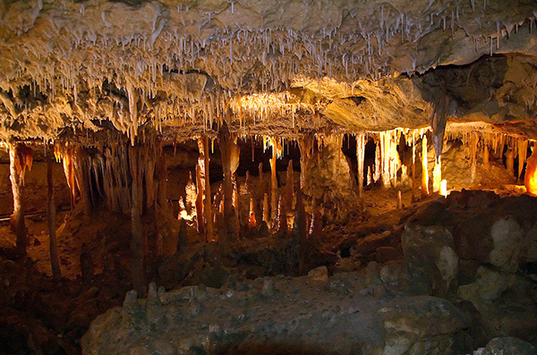
N'Dhala Gorge Nature Park—contains thousands of rock carvings (petroglyphs). These are relicts of the art and stories of the Eastern Arrernte people. This gorge is a cultural treasure house, with over 5900 individual petroglyphs, several art sites, shelter areas and other sites of cultural significance. The petroglyphs housed in this gorge are of two styles—the finely pecked and the pounded. They possibly represent two time periods. It is difficult to estimate the age of the art, but most were done within the past 2000 years, though some could be as old as 10,000 years. Aboriginal custodians for the site indicate that some of the designs are connected to the Caterpillar Dreaming story. It is also an important site for fire-sensitive plants, including Hayes wattle and white cypress pine, and rare plants such as the peach-leafed poison bush and the undoolya wattle. The gorge is 90km east of Alice Springs along a sealed road to Ross River Homestead. After the homestead, it's 11km of 4WD track, which crosses the Ross River several times and becomes impassable after heavy rain. Nabalco Pty Ltd—runs an alumina and bauxite operation in Australia's far north, established in 1964. Location: Nhulunbuy, Northern Territory. nabarlek—Peradorcas concinna, a type of wallaby which occurs in the Kimberley, the Northern Territory and in Arnhem Land. The nabarlek is 50-65cm long. The soft, woolly fur is in shades of light tan. The belly is lighter in color. Being marsupials, the females have a pouch in which the young live and drink milk. Males are larger than females. Babies are called joeys. These herbivores eat grass, leaves, and roots. They swallow their food without chewing it and later regurgitate a cud and chew it. They need very little water. Nabawa—a variety of wheat. naff—laughable; ridiculous; useless. naga/naga-naga—a loin cloth (as worn by Aborigines). nail it home—to push a point, fact before someone's notice; force to understand. nail (someone's) hide to the dunny door—1. reprimand, scold, berate (someone) severely. 2. thrash or beat (someone) soundly. nail-tailed wallaby—genus Onychogalea, are three species of macropod distinguished by a horny spur at the end of their tail. While the northern nail-tail wallaby (Onychogalea unguifera) is still common in the northern part of Australia, the crescent nail-tail (Onychogalea lunata) is now extinct, and the bridled nail-tail (Onychogalea fraenata) is considered rare and endangered, with probably fewer than 1100 mature individuals in the wild. Nail-tail wallabies are smaller than many other wallabies. Namadgi National Park—the most northern of the national parks within the Australian Alps. Containing more than half of the Australian Capital Territory and covering 105 900 hectares, the park's habitats range from sweeping, verdant valleys to snow-shrouded mountains studded with granitic outcrops. Snowfalls are likely in the winter months, mainly on the higher areas of the Brindabella and Bimberi ranges. The Cotter River, its headwaters part of the Bimberi Wilderness, bestows high quality water on Canberra, while sub-alpine bogs of sphagnum moss purify water. Marked walking trails cover 170km along which kangaroos, wallabies, and wombats are frequently encountered. For many decades, brumbies were also run in the rugged mountain ranges. Brumby-running died out during the 1960s. The snow gum and Alpine ash rails and the rusting wires of a few surviving trap-yards still remain. Namadgi National Park is located just south of Canberra. Namarkan sisters—the Dreamtime story of the Namarkan sisters was told to children to teach them the danger of crocodiles. In the story, the sisters had been sitting together at the edge of a billabong when one of them suddenly plunged into the water. She changed into crocodile, swam towards her sister and frightened her blue. She then changed back to a human being and turned over near her sister, who told her how it felt terrorizing people as a crocodile. Then the two girls thought that if they changed for good into crocodiles, they could frighten people and eat them. Today, the Namarkan sisters are present in each crocodile, one can see their mischievousness shining in their eyes, each animal being equipped with their skill of hunter. Nambung National Park—features beautiful beaches, coastal dune systems, shady groves of tuart trees and low heathland rich in flowering plants. The vegetation bursts into flower from August to October. In the midst of this diversity is the Pinnacles Desert, one of Australia's best-known landscapes. The first known European recording of the Nambung area dates back to 1658, when the North and South Hummocks first appeared on Dutch maps. The Hummocks were also mentioned in navigator Philip Parker King's journal in about 1820. Nambung is anAboriginal word that means 'crooked' or 'winding', and it was from this river that the park was named. The Pinnacles Desert remained relatively unknown until the late 1960s, when the Department of Lands and Surveys agreed to add the area to the already existing national park, which had been established in 1956. The park is a comfortable day trip from Perth. namby-pamby—person or thing that is insipid, weak, overly sentimental, simpering or wishy-washy. Namitjira, Albert—(28 July 1902—1959), born Elea Namatjira in the Aranda tribe. Though in his early career he painted a wide variety of subjects, he is best known for his watercolour Australian outback desert landscapes. Born near Alice Springs, he was raised on Hermannsburg Mission, Northern Territory and was baptised Albert after his parents' adoption of Christianity. Whilst his work is obviously the product of his life and experiences, his paintings are not in the highly symbolic style of traditionalAboriginal art; they are richly detailed depictions. His landscapes normally highlighted both the rugged geological features of the land in the background and the distinctive Australian flora in the foreground, with very old, stately and majestic trees surrounded by twisted scrub. Queen Elizabeth II became one of his more notable fans and he was awarded the Queen's Coronation medal in 1953 and met her in Canberra in 1954. He became popular, critically acclaimed and wealthy. Namatjira decided to use his wealth to lease a cattle station. This was not legally possible, however, because he was an Aborigine. He then tried to build a house in Alice Springs, which he was also prevented from doing because of his race. Because of his immense popularity this caused public outrage and the government subsequently granted Albert and his wife Australian citizenship in 1957, ten years before citizenship was granted to all Aborigines. Albert Namatjira is hailed as one of the greatest Australian artists of all time and a pioneer for Aboriginal rights. Namitjira's work is on public display in most of Australia's major art galleries. Namoi River catchment—covers approximately 41,998sq km and is located within the Murray-Darling Basin. The catchment has predominantly summer rainfall. Grazing is the dominant land use on the tablelands, with dry land cropping becoming more important in the slopes region. The plains support both grazing and farming enterprises, with irrigated cropping being significant. Tourism is also a major activity. Attractions include the largest exhibit of rural and agricultural products in the Southern Hemisphere, at Gunnedah, during Agquip; the country music festival at Tamworth; and natural attractions such as Mount Kaputar and Warrabah National Parks. Located in north-western New South Wales. nana—1. banana. 2. person who is easily fooled, tricked, duped, cheated. Nandewar bioregion—part of the Northern Tablelands, from northern NSW and across the Queensland border. The bioregion is bounded by the North Coast, New England Tablelands and Brigalow Belt South bioregionsin the south, east and west respectively. It spans an area of 2,700,313 hectares, with 2,069,604 hectares, or 76.6 per cent, falling in NSW and occupying 2.59 per cent of the state. Squatters began to occupy the area in the 1830s, with cattle grazing as dominant land use in the earliest days of European settlement, giving way to sheep grazing by the end of the century. The gold rush of the 1850s led to the rapid entrenchment of several towns in the Nandewar bioregion. The region has a history of bloody conflict betweenAboriginal and non-Aboriginal people, the best-known incident being that of the Myall Creek massacre. Nandewar Range—the remnants of a volcano that was active 17-20 million years ago. It rises abruptly from the surrounding plains to a height of 1510m at Mount Kaputar. The combination of volcanic soils, high rainfall and substantial variations in relief has resulted in a diversity of vegetation. Small patches of stunted, sub-alpine woodland consisting of white gum and snow gum growing within fields of snow grass are found on the high plateau areas. Heath and low scrub occur on the wind-swept peaks and rocky outcrops, while open forest with trees reaching 20-30m occur on hillsides subject to snow and severe frosts. Wet sclerophyll forest has developed in sheltered valleys of lower altitude, east of Mount Kaputar. Small patches of rainforest also occur in the deeper valleys in this part of the park. These rainforest remnants are very limited in extent, with dry sclerophyll forest predominating. Located in the Northern Tablelands region of New South Wales. Nankeen night-heron—Nycticorax caledonicus is a stocky but handsome bird. Although its name suggests that is strictly nocturnal, it often leaves its roost to feed in the afternoon, particularly when breeding, Indeed, it will feed all day in wet weather. Nankeen Night-herons will feed on insects, fish, frogs, tadpoles and crustaceans in and around freshwater rivers, lakes, bulrushes, estuaries, harbours and in residential fishponds for goldfish. They hunt by standing and waiting for prey, and then snatching it up with their thick bills. They will also swim, lying flat with legs extended backward. The Nankeen night-heron roosts and nests communally—sometimes in great numbers—in high, sturdy trees. A bird may roost in the same tree for many years. At dusk they fly out from their roosts with loud calls to other members of the colony, often travelling great distances to feed, and returning to the roost at dawn. Size: 56—66cm. Voice: Loud k-oark and deep-throated rumbling at roost. Found Australia-wide. Also known as rufous night-heron. nanna/nanny—grandmother. nanny-goat—(rhyming slang) tote; TAB. nannygai—various fish from the Australian region: In family Lutjanidae: malabar blood snapper, Lutjanus malabaricus; crimson snapper, Lutjanus erythropterus. In family Berycidae: eastern nannygai, Centroberyx affinis; yelloweye nannygai, Centroberyx australis. Family Glaucosomatidae: pearl perch, Glaucosoma scapulare. Nantawarrina Indigenous Protect Area—the first IPA, being declared on 26 August 1998. The property has an area of 58,000ha and is located in the (high priority) Stony Plains bioregion adjacent to the southern boundary of Gammon Ranges National Park in the northern Flinders Ranges of South Australia. The title to the land is held by South Australian Aboriginal Lands Trust (SAALT) on behalf of the Adnyamathanha people. Members of the Nepabunna community (near Leigh Creek) manage the Nantawarrina property with which they have traditional ties. The property is managed in accordance with IUCN protected areas guidelines, and an agreed plan of management which includes a 3-year work plan. Nantawarrina was among only three Australian winners of a UNEP Global 500 award on World Environment Day 2000 recognising the significant efforts of the Nepabunna community in managing Nantawarrina as an IPA. nap—a tip that a horse in a race will be a certain winner: e.g., He's a nap to win. Napier Range—a part of the Kimberley region, containing massive sandstone gorges. About 50km into the range, a narrow trail runs alongside the Lennard River leading to the picturesque Lennard Gorge, with moderately difficult walking trails and plenty of places to swim. Once part of an ancient barrier reef, the limestone ramparts were formed about 350 million years ago, in the Devonian period. Today, they are regarded by the scientific community as a treasury of endemic species and fossil deposits. The Napier Range encompass Geikie Gorge, Windjana Gorge and Tunnel Creek. Located in Western Australia. nappy—baby's diaper. nappy rash—diaper rash. Napranum—formerly known as Weipa, the Aboriginal community was established in 1898 by Moravian missionaries on behalf of the Presbyterian Church. The mission went inland near York Downs station to avoid contact with luggers who notoriously kidnapped Aboriginal people to use for their diving operations. In 1932 they had to relocate to Jessica Point, the present site, because of malaria. At this time most of the people were Awngthim but soon people were brought from Mapoon (when it was closed) and other communities. Bauxite was found on the reserve in the 1950s, with the Comalco Act of 1958 revoking the reserve status and allowing mining to commence in 1960. The mission became a government settlement in 1966, with continued attempts by Comalco to relocate the whole community elsewhere. The company then built a new town for its workers on the other side of the bay. Napranum eventually received DOGIT status, and has its own community council. Permits are available from the Nanum Wungthim Land & Sea Management Centre. The Napranum Bush Tours of Uningan Nature Reserve provide an Indigenous interpretation of the region's natural values. Naracoorte—a township renowned for its Scottish heritage and historic buildings, the nearby Bool Lagoon and Naracoorte Caves National Park. Naracoorte was named in 1869, following a decision to merge the two neighbouring towns of ‘Narracoorte’ and ‘Kincraig’. Its name is believed to have been derived from the Potaruwutjil word ngarankort, meaning ‘the place of the stone axe’. Aboriginal people traded these and other tools during ceremonies held at nearby swamplands over many hundred of years. Naracoorte is located in the Limestone Coast tourism region in the south-east coast of South Australia. Naracoorte Caves—a series of limestone caves, some of which contain fossil records. As the Australian continent broke away from the ancient landmass of Gondwana, the Southern Ocean surged closer inland by more than 100km from the current coastline. This watery invasion left behind deep layers of calcareous marine creatures, between 25 and 5 million years ago, which broke down into thick layers of limestone. The Naracoorte Caves were formed when high groundwater stands dissolved this limestone during the seas’ retreat to its present level. An entrance hole also formed in the roof of what is now known as the Victoria Cave, more than half a million years ago, through which the cave gradually filled with layers of trapped animals and sediment. The importance of the fossil record at Naracoorte was officially recognised in 1994, when the site was inscribed on the World Heritage list as the Naracoorte Cave National Park. Naracoorte Caves National Park—the 26 caves within this park have preserved a fossil record spanning 450,000 years. This timeline covers several ice ages and the arrival of humans to the continent, recording the megafauna prior to extinction during the late Pleistocene. About one quarter of the species found as fossils in the caves are totally extinct. As the Australian continent broke away from the ancient landmass of Gondwana, the Southern Ocean surged closer inland by more than 100km from the current coastline. This watery invasion left behind deep layers of calcareous marine creatures, between 25 and 5 million years ago, which broke down into thick layers of limestone. The Naracoorte Caves were formed as high groundwater stands dissolved this limestone during the seas’ retreat to its present level. An entrance hole also formed in the roof of what is now known as the Victoria Cave, more than half a million years ago, through which the cave gradually filled with layers of trapped animals and sediment. The group to suffer the most dramatic decline was the medium- to large-sized marsupials (those with a body weight greater than 5kg), with almost 80% of those found in the fossil deposits now totally extinct. The Naracoorte Caves National Park preserves 600ha of remnant vegetation as well as the Naracoorte caves, which are contained within the 305ha World Heritage area. Located in the Limestone Coast tourism region of south-east South Australia. Naracoorte Coastal Plain—a broad coastal plain of Tertiary and Quaternary sediments with a regular series of calcareous sand ridges separated by inter-dune swales, closed limestone depressions and young volcanoes at Mount Gambier. Vegetation is dominated by heathy woodlands and mallee shrublands with wet heaths in the inter-dune swales. Extensively cleared for agriculture. Naracoorte Range—a series of ancient, stranded dune systems formed by a series of marine transgressions and regressions. As Australia broke away from the ancient landmass of Gondwana, the Southern Ocean extended over 100 kilometres inland from the current coastline. A thick layer of limestone was formed between 25 and 5 million years ago, comprising shells, bryoza and calcareous bodies of other marine creatures. A series of caves were formed as high groundwater stands dissolved the limestone during the seas’ retreat to its present level. Naracoorte is located on the south-east coast of South Australia. Narawntapu National Park—(formerly Asbestos Range National Park) stretches from the low coastal ranges to the long Bass Strait beaches, and includes an historic farm, a complex of inlets, small islands, headlands, wetlands, dunes and lagoons. Small quantities of asbestos, among other minerals, were once mined around the edges of the Asbestos Range. The coastal heathlands are a feature of the park and contain six distinct heath communities, which is unusual in such a small area. In the vicinity of Archers Knob the rare, fern-like club moss can be found. More common heath plants include grass tree, trigger plant, blue bell, common heath, honeysuckle banksia, and ivy flat-pea. Dry sclerophyll woodlands occur on the inland hills, and behind Badger Beach are coastal wattles and tea tree scrub. Narawntapu National Park is located in the centre of Tasmania’s north coast, stretching from Port Sorell to the mouth of the Tamar River. nardoo—Marsilea drummondii, of mainland Australia, having clover-like fronds and occurring chiefly in arid areas along stream beds and near lakes. Nardoo is an unusual fern, which survives long droughts by rhizomes and hard fruit-like sporocarps, but grows rapidly once flooded. It has become famous in Australian folklore because the early explorers Burke and Wills starved to death while attempting to live on a diet of nardoo spores. The plant contains an enzyme (thiaminase) that destroys Vitamin B1. By rejecting the Aboriginal method of wet grinding and then baking the nardoo, which neutralises the toxic enzyme, the explorers developed a thiamine deficiency and died of beriberi. Nardoo ingestion also causes thiamine deficiency and death in sheep. However, the local Aborigines survived quite well with nardoo in their diet. The proper preparation of nardoo began with harvesting the plants once the shallow waters in which they grew had dried out. At this point the mature spore cases were scraped off narrow fronds and roasted, after which the inedible spore-cases were separated from the nutritious spores by grinding and blowing away the lighter 'husks'. Then the ground-up spores were placed in water, where they would swell. Finally, they were made into rolls or cakes which were again cooked, and then eaten. Nari Nari Tribal Council—(NNTC) established in 2000. It owns and manages three properties 40km west of Hay in New South Wales which were purchased on its behalf by the Indigenous Land Corporation under its land acquisition scheme. Cultural and environmental conservation projects are one of the central priorities of the NNTC. nark—an annoying person or thing. narked—irritated; annoyed; angry; upset: e.g., He's really narked over not getting that job. narna—(see: nana). Narrabeen Group—outcropping geological formations of sandstones within the Sydney Basin, formed mainly from Triassic sediments deposited in lakes in the unfolded parts of the geosyncline. The Narrabeen Group contains a wide range of sediments, and the sandstones developed widely spaced, intersecting vertical joint planes some time after sediment consolidation. Once these almost horizontal beds are exposed, the jointing pattern exerts a major influence on subsequent landform evolution, as the jointing promotes faster chemical weathering and the collapse of small and large sandstone blocks at cliff faces. The second group of the group's sediments are the overlying Hawkesbury Sandstones, which make up the plateau surface and cliff tops of the coastal area. Narrabri—the centre of a large irrigation and dry-land farming district to which cotton was introduced in 1962. By 1993, varieties bred by CSIRO at Narrabri constituted over 90% of the cotton grown in Australia. There are three scientific research stations dealing with agronomy in the Narrabri District: the University of Sydney's Plant Breeding Institute, the NSW Agriculture and Fisheries and the CSIRO Cotton Research Station. Located on the banks of the Namoi River, 420km by air north-west from Sydney, 40km west of the Nandewar Range, NSW. Narran Lakes—comprise lakes and wetlands associated with the Narran River west of Walgett, NSW. The wetland is the terminal drainage basin of the Narran River, and consists of overflow swamps through which flows the river to terminate in the large lake. Flooding occurs in approximately once in two to five years, after which water may persist for up to two years. The overflow swamp is vegetated with dense lignum, together with river cooba and coolibah along the river banks. Following flooding, there is a large influx of waterbirds to the area, and many species breed. Very large nesting colonies of straw-necked ibis occupy the overflow swamp, and large concentrations of ducks occur the lake as water recedes. As with other wetlands of this region, the Narran Lakes provide potential waterbird drought refuge when wetlands in other areas of the inland are dry. Narran Lake has been proposed for nomination to the Ramsar Convention. Narran Lakes Nature Reserve—has an area of 5,531 ha, covering part of the large, terminal wetland of the Narran River in New South Wales, which lies at the end of the Condamine River system flowing south from Queensland. It is of very high traditional, social and spiritual significance to Aboriginal people. The reserve is internationally significant for waterbird breeding and habitat, supporting a number of waterbirds that are listed under the Japan-Australia Migratory Bird Agreement and the China-Australia Migratory Bird Agreement. It was accepted as a Ramsar site in 1999.Narran River—a distributary of the Balonne River, north-west of Walgett, NSW. The area consists of gilgai overflow swamps through which the river flow to terminate in Narran Lakes. Vegetation along the river consists of dense lignum and river cooba. Narran River tribes—Aboriginal people of New South Wales. narrawa burr—Solanum cinerum, a member of the Solanaceae family in company with potatoes and tomatoes. There are 1500 Solanum species and of these 117 occur in Australia. It is an erect shrub reaching a height of one metre. The species will often sucker. Except for the petals and seeds, every part of the plant is armed with sharp prickles. Purple-mauve flowers are a striking feature and flowering occurs for many months. The anthers need to be vibrated to release their pollen, and native bees have this capability but introduced honey bees do not. Solanum cinereum is a widespread species. It is found in nearly all botanical divisions in New South Wales as well as Queensland and Victoria. narrow between the ears—(of a person) stupid; dumb; witless; lacking in intelligence. narrow-banded snake—Simoselaps fasciolatus, listed as Vulnerable on the schedules of the NSW Threatened Species Conservation Act. The species was listed because: Its distribution has been reduced, it faces moderate threatening processes, and it is an ecological specialist (it depends on particular types of diet or habitat). narrow-leaved boronia—Boronia anethifolia, a shrub 0.3-1m high, glabrous; branchlets 4-angled, or with 2 grooves separated by decurrent leaf bases, glandular-warty. Leaves bipinnate with 3-5 pinnae, lower pinnae each with 3 leaflets; rachis 7-25mm long; leaflets linear to linear-elliptic, 3-15mm long, 1-2mm wide, apex acute, margins entire, glabrous, glandular-warty; petiole 6-15mm long. Inflorescences axillary, cymes shorter than the leaves, mostly 3-7-flowered; pedicels 2-4mm long. Calyx mostly glabrous. Petals 3-4 -mm long, imbricate, white to pale pink or orange, persistent in fruit. Grows in heath and dry sclerophyll forest on sandstone ridges and rocky slopes; north from Tahmoor district, NSW. narrow-leaved ironbark—Eucalyptus crebra, a spreading tree to 15m, found only on the Eyre Peninsula, and is reported as bushier than the species. It is often planted along the highway and used for shelter. The bark is smooth and has mottled colors of orange, yellow and gray. The bud clusters of 5-16 are found on leafless branches. Tolerates heavy soils and is frost resistant. Used for ornamental plantings, shade trees, sawmill timber, firewood, honey production, coastal plantings, wind resistance, koala browse. Native to New South Wales and Queensland. narrow-leaved peppermint—Eucalyptus nicholii, a small to medium tree with rough, fibrous, grey or grey-brown bark and narrow, dull, greenish-grey leaves. Ideal for windbreaks and shelter, it is an attractive, pyramid-shaped tree with abundant small, white flowers from autumn to early spring. Endemic to the Northern Tablelands of NSW.
|