| Search JoyZine with Google Site Search! |
Australia Decoded
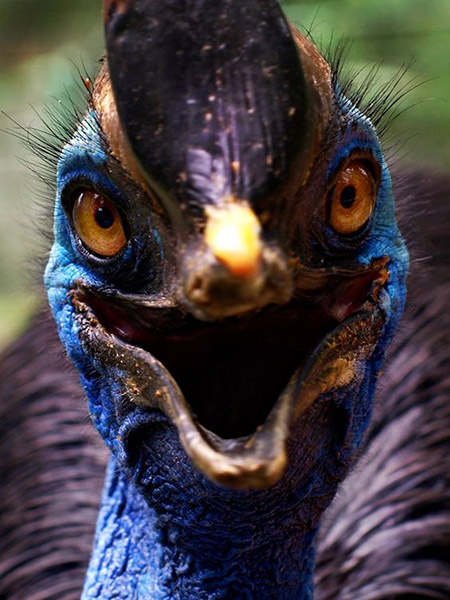
song cycle—the Dreamtime beings set patterns for all their creations to follow. Known as the Law, these are encoded in the song cycle and ceremonially passed on from one generation to the next. The song cycle is used to convey from one generation to another a detailed description of the land and how it has been shaped. These songs are still sung today by tribal Aborigines. Because the Law originated from the north, places with special environmental and mythological significance are sung in sequence from north to south. This sequence also influenced the pattern of an age-old route of trade and exchange which originated in the Kimberley and extended as far as Uluru. All the special places named in the songs, many of which are passed on the trail, have their own character or feeling, known as Le-an. The Le-an is believed to be alive, and affects people both positively and negatively. It can make you feel happy and elated or sad and thoughtful. songline—the Aborigine's songline begins with the first stirring in the mother's womb. The elders are called to decide which ancestor walked that way, and they reserve the yet-to-be-born child a 'conception site'—coinciding with the nearest landmark on the songline. In Aboriginal Australia, there are specific rules for 'going back' or, rather, for singing your way to where you belong: to your 'conception site', to the place where your tjuringa is stored. sook/sooky—1. a cry-baby; person prone to tears. 2. cowardly, frightened, timid person. sool—to incite, encourage a dog to attack. sooty grunter—Hephaestus jenkinsi, a common freshwater species in the Kimberley, extending west to the Fitzroy River and is closely related to the sooty grunter from the Northern Territory and Queensland, H. fuliginosus, which has been bred and used for stocking farm dams by Queensland Department of Primary Industries for a number of years. These fish feed most actively around dusk and early morning. The fish behave in a manner consistent with their tropical distribution in that feed consumption increases as temperature is increased progressively from 25oC to 34oC but is depressed at 36oC. sooty owl—Tyto tenebricosa is a medium large, sooty black owl with very large, dark eyes set in a round facial disc. They are the great, dark owls of the southern Australian rainforests, where they live in the deep, moist gullies in eucalypt forest, usually with big, old, smooth-barked gums and an understorey of tree ferns and lilly pilly in the coastal and mountain regions of south-eastern Australia from the Dandenong Ranges near Melbourne to the Conendale Range north of Brisbane. Reportedly present on Flinders Island in the Bass Strait. They are territorial and sedentary throughout the year. Known also as black owls or dusky barn owls, they are rarely seen or heard, for few people venture into their forbidding habitat at night. The sooty and lesser sooty owls are the most nocturnal of all Australian owls. The characteristic call is a piercing downscale shriek, lasting for upwards of two seconds. It has been likened to the sound of a falling bomb without the final explosion, and the call is now widely known as the 'bomb whistle'. The sooty owl is a powerful hunter—sugar gliders and ringtail possums make up a high proportion of the prey but a wide variety of other mammals have been recorded. sooty oystercatcher—Haematopus fuliginosus, inhabits rocky shorelines and coastal islands along the coast of Australia. It forages in the littoral zone, the region between high and low tide marks, and preys upon a variety of molluscs and crustaceans. It appears to breed mainly on marine islands, a limited breeding resource which appears to place an upper limit on its population size. Non-breeding birds inhabit rocky shore areas all year round. Sooty oystercatchers require access to a larger area of littoral zone during the breeding season to supply all the food requirements of both parents and chicks. This is achieved by the pairs maintaining both breeding and post-breeding territories, the size of which depends upon prey density. On many islands littoral zones are restricted to vertical rock faces, which are not readily accessible to oystercatchers. Such islands provide limited habitat and may support only one or two pairs. More rarely the littoral zone may occur as a rocky platform offering a relatively large foraging area for oystercatchers, resulting in much higher population densities—such as those on Flinders Island at the Five Islands Nature Reserve. Overall, the New South Wales sooty oystercatcher population is small and widely distributed, with only 100 individuals recorded in 1987. sop—coward; weakling. sorf!—piss off! sorf or I'll son ya!—piss off or I'll piss on you! Sorrento—a seaside settlement of 1500 people, near the western tip of the Mornington Peninsula. The original settlement at the Sorrento site was known as Sullivan's Bay. Sorrento is an extremely popular destination for day and weekend trips as well as the Christmas holidays. Located 91km south-west of Melbourne. sort—1. an attractive person: e.g., He's a real sort! 2. type of person: e.g., He's not such a bad sort. sort (someone) out—1. set (someone) straight as to the true facts. 2. deal with, punish (someone). sorted—dealt with; straightened out; e.g., I'm glad we finally got that problem sorted. soup-strainer—a moustache. South—originally the south Melbourne VFL football team, now taken over by the Sydney Swans. The South Alligator River is also about 160 km long. It rises north of Mount Stow also on the Arnhem Land plateau. It flows north-westerly in a valley containing a number of disused uranium mines developed between 1955 and 1965. It also finishes in the Van Diemen Gulf of the Timor Sea. South Alligator River—the major source of water for wetlands of Kakadu National Park. All tributaries of the South Alligator River derive from the Kakadu Escarpment. The river is about160km long. It rises north of Mount Stow, also on the Arnhem Land plateau, flowing north-westerly in a valley containing a number of disused uranium mines developed between 1955 and 1965. It finishes in the Van Diemen Gulf of the Timor Sea. South Alligator River catchment—presently characterised by spatially variable but severe soil and vegetation degradation associated with feral water buffalo and, to a lesser extent, feral pigs. Following the recent large-scale removal of buffalo in the region, different landform-erosion systems are expected to stabilise at different rates. Flood basins will recover rapidly—experience in the region indicates between 2 and 5 years. Floodplains (gullying, extensive sheet erosion, soil structure damage, weed invasion) will take much longer to stabilise—probably of the order of several decades. Channels and levees will take a similar length of time to stabilise, as they adjust to changed hydrological and sediment conditions associated with feral animal erosion. Revegetation of eroded areas will be more rapid. South Alligator uranium mines—there are four active mineral leases within the Alligator Rivers region (ARR) which pre-date the proclamation of Kakadu National Park. These are Ranger, Jabila, Koongarra and Nabarlek. Ranger is currently the only operational uranium mine in the ARR. Jabila, located 20km north of the Ranger site, is in the early development stages although mining of the orebody has not yet commenced. Koongarra is a significant uranium deposit which is yet to be subject to the process of seeking permission to develop the mine. Nabarlek ceased mining and milling activities in the late '80s and has now been decommissioned and substantially rehabilitated. The history of uranium mining in the Alligator Rivers Region (ARR) dates back to the 1950s and there are a number of former uranium mines in the South Alligator Valley of the ARR, which were subject to mining activity from 1954 to 1964. South Alligator Valley—one third of all Australian bird species, a quarter of its fish species, 50 mammal, 75 reptile and 25 frog species live here. A recent scientific survey has discovered a rare miniature marsupial called the red-cheeked dunnart—a mouse-like creature. Other rare species are the pig-nosed turtle and the hooded parrot. An area of numerous uranium deposits, many of which were mined during the 1950s and '60s. Known to the indigenous Jawoyn people as Sickness Country, the South Alligator Valley is located in Kakadu National Park, Northern Territory. South Australia—capital Adelaide; the State is situated along the Indian Ocean and covers 984,377sq km of south-central Australia. The first recorded sighting of the South Australian coast was in 1627 when a Dutch ship examined the coastline. The first systematic charting was by a British expedition under Matthew Flinders and a French expedition under Nicholas Baudin in 1802. After that, sealers and whalers established rough camps and rough lives on Kangaroo Island and the mainland. With official European settlement in 1836 it became a British colony, and joined the Commonwealth of Australia in 1901. Most of the State's population reside in the fertile coastal areas and in the valley of the Murray River, the State's only navigable waterway. The terrain consists largely of dry wasteland, with several low mountain ranges, the most of which is the Mt Lofty-Flinders Ranges system, which extends north about 800km from Cape Jervis to the northern end of Lake Torrens. More than half the nation's wines are produced here, and its principal industries are wheat, wine and wool. South Australia Company—an organisation formed on 9 October 1835 to develop a new colony in South Australia. The founding shareholders were George Fife Angas, Thomas Smith and Henry Kingscote, who were soon accompanied by some 300 additional shareholders. Among these were John Rundle, Charles Hindley, Raikes Currie, John Pirie and Henry Waymouth. In January 1836 four ships sailed from England, on behalf of the company. They developed a settlement at Kingscote, in July 1836, but when farming proved unviable, they transferred their settlement to the mainland. The company provided basic infrastructure for the new colony, as well as sold or leased land to immigrants who came to settle. The South Australia Company ended business in it's own right on 17 March 1949, when its management was transferred to Elders Trustee. South Australian merino—while the Peppin sheep were developed for the temperate climate of the slopes and plains and particularly for the Riverina, South Australian merinos were specifically bred to thrive and provide an economic return from wool in the arid pastoral conditions found in much of the state. Rainfall in these districts is mostly in the vicinity of 250mm per year or less, and plants such as the saltbush make up a large part of the natural vegetation. The South Australian is physically the largest of the strains of merino sheep in this country. The wool from these sheep is at the coarsest (i.e. thickest in fibre diameter) end of the range of Merino wool types. It also tends to carry a higher proportion of natural grease, which has been specifically sought by breeders to provide protection to the fibre under the most adverse grazing conditions. Apart from South Australia, this strain of merino is found in significant numbers in the pastoral regions of Western Australia, Queensland and New South Wales. South Australian Museum—offers visitors six floors of exhibits that reveal many fascinating stories. Exhibitions and displays reflect the museum’s extensive Australian Aboriginal and Pacific collections and the Ancient Egyptian room has been a favourite destination for generations of museum visitors. The South Australian Museum enjoys an international reputation for the size and representation of its collections, as well as the breadth and quality of its scientific research. South Australia’s unique fossil history is reflected in the Origin Energy Fossil Gallery. Visitors can view 40,000 year old megafauna fossils, the wonder and beauty of 120 million year old opalised fossils and Ediacaran fossils, such as the 550 million year old chordate, possibly the oldest ever found. The chordate is a fossil from the branch of the tree of life that led to animals with backbones, including humans. Museum visitors can bring specimens for identification to the popular Discovery Centre and staff in the Indigenous Information Centre answer questions about Australia’s Indigenous cultural heritage. The Museum offers a comprehensive teaching program, linked to curriculum in schools from reception to year 12 for around 38,000 students a year. The South Australian Museum is situated in the cultural heart of Adelaide, alongside the Art Gallery of South Australia and State Library of South Australia. South Australian shatter zone—a zone in which complex earth movements over a long time have caused both uplift and subsidence. South Bruny National Park—lies at the southern tip of Bruny Island off the south-east coast of Tasmania. The park encompasses all of the coastline and some of the hinterland between Fluted Cape and the southern part of Great Taylors Bay. South Bruny National Park was gazetted in 1997, mainly for its wonderful coastal scenery. Much of the coast comprises towering cliffs, muttonbird rookeries, gardens of kelp seaweed and long, sandy beaches. In some areas the park extends several kilometres back from the coastline, where lush rainforest may be found containing several endemic plant species. The popularity of South Bruny National Park as a tourist destination is enhanced by its abundant birdlife, coastal heathland and its prominent place in the history of Tasmania. Adventure Bay and Jetty Beach provide safe, sheltered areas for swimming, while Cloudy Bay is a popular spot for experienced surfers. South East Coastal Plain bioregion—undulating Tertiary and Quaternary coastal plains and hinterlands occur in several distinct segments (Warrnambool Plain, Otway Plain and Gippsland Plain), rising to 200m in altitude and extending from Tyrendarra in the west to Lakes Entrance in the east and including Geelong, eastern Melbourne and the Mornington Peninsula. The area has a temperate climate with rainfall varying from about 500mm to 1100mm, typically with higher rainfall in winter. Adjacent areas of higher altitude (e.g. the Otway and Strzelecki Ranges) produce rainshadow effects in some parts of the area. The area east of Warrnambool is characterised by deeper soils of volcanic origins overlying limestone, which are dissected by streams. The Otway Plain includes coastal plains, river valleys and foothills from the Bellarine Peninsula west to Princetown. A small isolated component at Werribee, on the western shore of Port Phillip Bay, is included. The Gippsland Plain includes lowland coastal and alluvial plains characterised by generally flat to gently undulating terrain. The coastline is varied and includes sandy beaches backed by dunes and cliffs, and shallow inlets with extensive mud and sand flats. The vegetation includes lowland forests, open forests with shrubby or heathy understoreys, grasslands and grassy woodlands, heathlands, shrublands, freshwater and coastal wetlands, mangrove scrubs, saltmarshes, dune scrubs and coastal tussock grasslands. Extensively cleared for agriculture. South East Corner—a bioregion consisting of a series of deeply dissected near coastal ranges composed of Devonian granites and Palaeozoic sediments, inland of a series of gently undulating terraces (Piedmont Downs) composed of Tertiary sediments and flanked by Quaternary coastal plains, dunefields and inlets. The regional climate is strongly influenced by the Tasman Sea and the close proximity of the coast to the Great Dividing Range. Vegetation consists of high-elevation woodlands, wet/damp sclerophyll forests interspersed with rain-shadow woodlands in the Snowy River Valley. Lowland and coastal sclerophyll forests, woodlands, warm temperate rainforest and coastal communities occur in the lower areas. Includes the towns of Bateman's Bay, Moruya, Narooma, Bermagui, Bega, Merimbula and Eden. Most of the bioregion's population lives in the towns along the coast. The Clyde, Deua, Moruya, Buckenbowra, Brogo, Wadbilliga, Towamba, Genoa and Tuross Rivers traverse the bioregion. The main catchments areas are the Clyde, Deua, Tuross, Bega, Towamba and Genoa river catchments. South Eastern Highlands—dissected and rugged ranges extending across southern and eastern Victoria and southern NSW, just inland from the coastal bioregions of the South East Corner and the Sydney Basin, bounded by the Australian Alps and South Western Slopes bioregions to the south and west, and includes most of the ACT. Steep, predominantly Palaeozoic rocks and Mesozoic rocks are featured. The vegetation is predominantly wet and dry sclerophyll forests, woodland, minor cool temperate rainforest and minor grassland and herbaceous communities. Large areas, particularly in the box-ironbark forests, were felled for fuel and timber for the mines during the gold rushes in Victoria. Large areas have also been cleared in NSW for grazing or plantations. The Lachlan, Macquarie, Murray, Murrumbidgee, Shoalhaven and Snowy Rivers all flow across this bioregion. South Eastern Queensland bioregion—metamorphic and acid to basic volcanic hills and ranges (Beenleigh, D'Aguilar, Gympie, Yarraman Blocks) sediments of the Moreton, Nambour and Maryborough basins, extensive alluvial valleys and Quaternary coastal deposits, including high dunes on the sand islands such as Fraser Island. Humid. Eucalyptus-brush box-turpentine tree tall open forests; eucalyptus open forests and woodlands; sub-tropical rainforests, often with hoop pine emergents and small areas of cool temperate rainforest dominated by Antarctic beech and semi-evergreen vine thickets, paperbark tea tree wetlands and banksia low woodlands, heaths and mangrove/saltmarsh communities. South Georgian diving-petrel—Pelecanoides georgicus is extremely similar to the common diving-petrel in most aspects of their plumage and morphology. Their distribution at sea is not well known because it is difficult to separate South Georgian diving-petrel and the common diving-petrel species at sea. However, it is believed that the South Georgian diving petrels do not move very far from their breeding colonies. They feed mainly on marine crustaceans, together with some small fish and cephalopods. They breed on many subantarctic islands, including Codfish Island and Auckland Island close to New Zealand, Marion Island, Iles Crozet, Heard Island and South Georgia. South Georgian diving-petrel return to their colonies in September-October and lay one egg. After 44-52 days of incubation, chicks hatch and are brooded by both parents. Breeding birds deliver meals to chicks, which are almost 20% of adult mass. Hatching and fledging success rates fluctuate depending on the predator species present and their abundances. Brown rats and feral cats have serious impacts on the breeding status of South Georgian diving-petrel at South Georgia. South Gippsland Highlands—during the upper Cretaceous and early Tertiary periods, extensive lava flows occurred within many of the valleys in South Gippsland. Extensive present-day outcrops are located in uplifted areas of the South Gippsland Highlands (north of Mirboo), around the eastern margin of the ranges and around Leongatha and Dumbalk. In other areas they have been covered by subsequent Tertiary and Quaternary sediments. Victoria experienced a warm and wet climate throughout much of the Tertiary period and temperate rainforest was widespread over the state. During the Tertiary period (from approximately 65 million years ago) Australia continued to drift away from Antarctica (at rates of up to 6cm per year). Three interconnected basins (Otway, Gippsland and Bass) formed along the southern edge of Victoria's continental plate and significant marine sediments were laid down in shallow seas. Some parts of these basins now lie onshore but most are to be found beneath Bass Strait. The sea level fluctuated significantly during Tertiary times. Following the uplift of the South-Eastern Highlands in the Tertiary period (approximately 5 million years ago), extensive river systems developed over dry land areas. These rivers developed deep channels, which were filled with coarse gravels. Some of these have been preserved as river terraces along present-day streams. As the uplands became more and more eroded, the rivers draining them became much reduced. These slower-flowing streams then deposited only fine-grained sediments such as silt. As a result the coarser gravels were covered by finer-grained sediments. South Land—Australia. south Queensland kauri—Agathis robusta, an Australian timber tree resembling the kauri but having wood much lighter in weight and softer. Extensively used in the past for plywood, cabinet work, furniture, indoor fittings, boat building and turning. In early homes it was also used for kitchen sinks, bench tops, cutting boards, and flooring. Now almost completely logged out. South Stradbroke Island—separated into North Stradbroke and South Stradbroke by a storm in 1896, South Stradbroke Island is only 22km long and about 2.5km wide. Although sighted by both Captain James Cook and Matthew Flinders, it wasn't until 1827 that the name Stradbroke, after the then Earl of Stradbroke, was given to the island by his son, Captain H. J. Rous, the commander of the HMS Rainbow. South Stradbroke is one of Australia's rare and unique sand islands. Undeveloped, and with an unspoilt beauty, it boasts a vigorous diversity of flora and fauna, some of which, like the golden wallaby are found nowhere else in the world. From the air, the resort is almost undetectable as it nestles into the natural environment. It has been designed to blend harmoniously with it's surroundings and give it's guests an affinity with the delicate balance of the island. Twenty seconds walk from the resort are the calm and tranquil Western beaches. Protected by the island from strong currents and ocean waves, the lagoon-like waters are perfect for swimming, fishing, boating, or making use of the many Watersports attractions available. South Western Slopes—a bioregion comprising a large area of foothills and ranges that make up the western fall of the Great Dividing Range to the edge of the Riverina bioregion. A very wide range of rock types is found across the bioregion, which is also affected by topographic and rainfall gradients that decrease toward the west. Granite landscapes are common, occurring either as central basins surrounded by steep hills formed on contact metamorphic rocks, or as high blocky plateau features with rock outcrops and tors. The overall pattern of soils in these landscapes is one where shallow, stony soils are found on the tops of ridges and hills. Moving downslope, texture contrast soils are the norm with subsoils derived from the underlying weathered rock and the topsoils being an homogenised surface mantle of coarser material derived from all parts of the slope. On valley floors, dryland salinity is widespread. The South Western Slopes bioregion lies wholly within the eastern part of the Lachlan Fold Belt. south-eastern lined earless dragon—Tympanocryptis lineata. Its habitat is naturally treeless grasslands on black clay, brown clay loams and podzolic soils. It appears to prefer grasslands of Themeda, Danthonia and Stipa spp. that have not been grazed or are only lightly grazed. There is evidence for a substantial decline in the geographic range, it is now found only on the basalt plains of southern Victoria, the southern tablelands of New South Wales and the ACT. It often seeks the shelter of rocks and has been seen retreating into small holes, like those of the trap-door spider. southerly buster—(south-eastern Australia) a sudden change in weather, bringing windy conditions and a drop in temperature. southern angle-headed dragon—Hypsilurus spinipes is native to eastern Australian rainforests and rainforest margins from around Gosford in NSW to near Gympie in Queensland. It has a large and continuous nuchal crest with a moderately large vertebral crest. The angular brow is pronounced on both adults and juveniles. The snout-to-vent length is around 110-150mm; additionally, there is a long tail which takes the total length to 35cm. The colours vary from shades of brown to grey and green. Patterns, where present, comprise various irregular mottling, blotches and variegations. The southern angle-headed dragon is cryptic, slow moving and well camouflaged. It is sometimes encountered basking in sunlight after rain, often perching on buttresses, sapling stems or old stumps. They tend not to dash for cover, but slide discreetly out of view. The diet includes insects and other arthropods such as spiders and centipedes. Eggs are laid in shallow nests in rainforest clearings, including road edges and walking tracks. There is some evidence that they will occasionally lay communal nests. The eggs are vulnerable to predation, particularly by goannas. southern beech—Nothofagus beardmorensis, an anciently extinct tree of the Antarctic region. The leaves occur abundantly in lake sediments that are, in their turn, under- and over-lain by glacial sediments. The leaves represent an autumn leaf-fall and are very similar to, though larger than, the Tasmanian species of Nothofagus gunnii (also known as the deciduous beech). southern boobook—Ninox novaeseelandiae, the smallest (28—36cm) and most common owl in Australia, found throughout mainland Australia and Tasmania, and on some coastal islands. It is identified by its plumage, which is dark chocolate-brown above and rufous-brown below, heavily streaked and spotted with white. The facial disc is chocolate brown and the eyes are large and yellowish. Birds are often observed perched on an open branch or tree-top, emitting a distinctive boo-book or mo-poke. They are seen in a variety of habitats, from dense forest to open desert. The southern boobook feeds on insects, small mammals (such as the house mouse) and other small animal species. Feeding takes place mostly at night but some afternoon and morning activity may occur, especially on dull days. Most prey is detected by listening and watching from a suitable tall perch. Once detected, flying prey, such as moths and small bats, are seized in mid-air, while ground-dwelling prey are pounced upon. southern brown bandicoot—Isoodon obesulus, a greyish or yellowish brown on its back and creamy white on its stomach. Like all bandicoots, the southern brown bandicoot is solitary and nocturnal. It is an opportunistic omnivore, feeding mainly on terrestrial invertebrates, including beetles and insect larvae, plus plant material and fungi which it digs from the soil with its powerful fore-claws. It inhabits a wide variety of habitats, from dense forest to heathland,although it appears to favour recently burnt areas. It is the most widespread of the bandicoots, occurring throughout much of Australia, excluding arid and semi-arid regions. Also known as the short-nosed bandicoot or the southern short-nosed bandicoot. southern cassowary—Casuarius casuarius stands about 1.8m to the top of the head when the neck is fully raised, and weighs around 60kg—70kg. The large greyish helmet (casque) and the red wattle hanging from the neck make it easily identifiable. The feathers of the body are black and hair-like. The bare skin of the head and fore-neck is blue, while the rear of the neck is red. In appearance, the southern cassowary looks like a short, heavily-built, black and blue emu. Both species are indeed closely related, and both are flightless. They inhabit rainforests of northern Queensland. In parts of its range the species is still relatively common, but numbers are decreasing. Throughout their range, southern cassowaries live alone and inhabit the same area all year round. They feed mainly on fruit that has fallen to the ground but will also eat anything from snails to small, dead mammals. If two males should meet, they have a stand off where both birds stand tall, fluff up their feathers and rumble at each other until one retreats. If a male and female meet, the male will move away, as the female is dominant. Females may lay several clutches of eggs during the breeding season that runs from June to October. These are laid directly onto the forest floor and the male than takes sole responsibility for their care. The male incubates the eggs for around 50 days, turning the eggs and only leaving his charges in order to drink. He cares for his offspring for up to 16 months, protecting them under his tail if threatened. Cassowaries fight by kicking out with their legs—they have a fearsome reputation. These birds are important dispersers of a number of rainforest seeds, ranging far in search of fruiting trees. southern corroboree frog—Pseudophryne corroboree. The striking black and yellow stripes make this species easy to recognise. The species is only found at high altitudes within an area of about 400 square kilometres in the sub-alpine area of Kosciuszko National Park in New South Wales and the ACT. It uses two distinct types of habitat during its lifecycle: pools, wet tussock grass and wet heath for breeding; and forest, sub-alpine woodland and tall heath next to the breeding areas during other times of the year. Females only breed once a year, and the tadpoles are slow growing, spending over six months in shallow pools. Southern Cross—1. the constellation of Crux Australia, seen only in the Southern Hemisphere, four stars of which form a cross, and depicted on the Australian flag. 2. Xanthosia rotundifolia, the national flower of Australia, named for its resemblance to the constellation. 3. the last town on the edge of the wheatbelt and site of the first major gold discovery in the huge eastern goldfields region. There was a small gold rush but it was short-lived. Located 357m above sea level and 368km east of Perth on the Great Eastern Highway. Today the area produces oats, barley, wheat, sheep and gold, but the average annual rainfall of 279mm means that the land is marginal. 4. An area within the Yilgarn Craton. southern emu-wren—Stipiturus malachrus, a tiny bird whose narrow, cocked tail consists of six wispy feathers—in quality, like the feathers of the emu. The southern emu-wren is streaked brown, with a pale blue throat in the male. Feeds on insects, leaf eating beetles, plant bugs, weevils and spiders. Inhabits coastal heathlands, tea-trees, swamps and dense vegetation. Breeds between August and January; the nest is oval with an opening on the side and is one metre off the ground. Two to four eggs are laid and incubated by the male. southern hairy-nosed wombat—Lasiorhinus latifrons is similar in size to common wombats but they have softer, silkier, grey fur, longer, pointed ears and fine fur on their much broader nose. It is a squat, marsupial quadruped with short, thick limbs that are equipped with short, flattened claws. Its tail is reduced. Its proportions are typical of digging mammals. It is the smallest of the wombats, attaining a meter in length at most. The fur of this wombat covers the entire body, including the nose, hence its name. This mammal is well adapted to arid conditions, spending the day in a deep burrow in a communal warren. Each warren is home to five to ten individuals and the warrens themselves are frequently in groups, leading to high local densities. When in a burrow, the wombat's temperature drops considerably, thus conserving energy and reducing the loss of water by evaporation. All wombats are diggers, as is suggested by their powerful front limbs. This species is mainly nocturnal, feeding upon grasses, roots, sedges, bark, and fungi, which are often highly fibrous and low in water and protein. The female becomes sexually mature at three years of age. Though breeding can occur at any time of year, most young are born from September to December. Mating may be delayed for several years at a time if the sporadic rainfall in its habitat is insufficient to bring on a flush of plant growth. The female has two teats in a large, backwardly directed pouch but it is usual for only one young to be reared, remaining in the pouch until about nine months old and thereafter following its mother at heel until becoming independent when about 12 months. Only three species of wombat survived the Pleistocene to 'modern' times, i.e. the last 10,000 years. After the Pleistocene the southern hairy-nosed wombat was distributed from the eastern corner of Western Australia across South Australia to the Murray River. Its close relative, the northern hairy-nosed wombat (Lasiorhinus krefftii), was still present in northern Victoria and southern New South Wales as well as in southeastern Queensland, but fossil records show that it had been much more widespread during the late Pleistocene. The common wombat (Vombatus ursinus) occupied a stretch of country from south-eastern Queensland, through New South Wales along the Great Dividing Range and associated ranges, to Victoria, where it was spread over all but he north-western corner. Almost the first thing that Europeans did when they sighted a wombat in 1797 was to eat it. Its conservation status is Endangered (likely to become extinct if threats continue). Southern Hemisphere—that half of the earth which lies south of the equator. Outstanding differences between the hemispheres include: celestial markers (e.g., navigational astronomy); flora: many of the plant groups which now dominate the Southern Hemisphere floras, for example the Proteaceae and Myrtaceae, are believed to have had their origins in Gondwana before it began to break up about 120 million years ago; and fauna. Southern Highlands—a region lying approximately 120km south-west of Sydney, atop an escarpment overlooking the South Coast. The area has landscapes ranging from rolling pasturelands to forested mountains. Popular bushwalking trails are located at Mount Gibraltar, Mount Alexander, Carrington Falls, the Robertson rainforest, and within the wilderness of the Kangaroo Valley. Morton National Park is located at the northern tip of the highlands, featuring the spectacular Fitzroy Falls, and a fine example of underground, limestone caves is found in the Wombeyan Caves. Southern Hills and Basins—The habitats of the southern hills and basins region of the Kakadu area support several endemic plants not found anywhere else in the world. One example is the untidy Eucalyptus koolpinensis, known from only two populations near Jarrangbarnmi (Koolpin Gorge). Perhaps the most noticeable plant in the woodlands of the south of Kakadu Park is the salmon gum. When this tree sheds its old, white bark it exposes a beautiful, salmon-coloured bark, which gradually fades to white and is shed the following year. Southern Ocean—the only ocean that encircles the globe. Its waters circle Antarctica and wash the shores of southern Australia, New Zealand, South Africa and South America. English, Dutch and French explorers of the eighteenth century ventured into the Southern Ocean in search of a "great southern land", the hoped-for continent of terra australis. Because of the absence of barriers to atmospheric and oceanic circulation, the flow of Southern Ocean surface waters is very similar to the atmospheric patterns on land. Understanding the circulation of the Southern Ocean and its interaction with the atmosphere and sea-ice lies at the heart of reliable predictions of climate change. Researchers at CSIRO Marine Research and the Cooperative Research Centre for the Antarctic and Southern Ocean Environment, together with US colleagues, have been studying the ocean between Australia and Antarctica for the last 7 years. This ocean is among the world's most fertile and productive ecosystems, home to millions of penguins, seals, whales and birds that rely directly or indirectly on various stages of the krill life cycle as a source of food. southern oscillation—the major air-pressure shift between Asia and the eastern Pacific regions. Related changes occur in the trade winds, in cloud patterns and in rainfall across the tropical Pacific. The oscillation is measured by an index of pressure difference between Tahiti and Darwin. When the index is positive, the trade winds blow strongly across the Pacific, feeding moisture into the monsoons of Asia and Australia. When the index is negative, trade winds are weak or even reversed; monsoons are deprived of their energy source; and rainfall is much below average, over the Australian/Asian region. southern potoroo—Potorous tridactylus, a small, rabbit-sized marsupial with relatively long hind legs; a pointed snout; short, round ears; and a short, tapering, prehensile tail. Its fur is long, soft and straight, and a grizzled reddish-gray or near- black color on the back. The belly is whitish, and its tail often has a white tip. The average head and body length of the potoroo is about 7cm, with a weight of about 1-2kg. The smallest of the macropods (Latin for "large feet"), the southern potoroo inhabits dense undergrowth and tall grass in well-forested areas. Its nest is of dry grass. In motion it is a diminutive kangaroo, moving slowly on its hind legs only, covering about 5 to 8with each bound. Strictly nocturnal, the southern potoroo eats mostly grass and fungi, together with other plant material, and consumes insects when abundant during spring and summer. It scratches shallow holes in the ground to obtain food, which it then eats squirrel fashion, using its hands. Also known as long-nosed rat-kangaroo. southern purple spotted gudgeon—the species went from abundant in the River Torrens in SA in 1920 to scarce by 1940s. southern right whale—Eubalaena australis, called "right whales" by whalers because they are slow moving, yield a great amount of oil and float while they are dead. Found in the Southern Hemisphere, this whale migrates to calve in sheltered bays along the coast of southern Australia, and can be seen in winter and spring. In 1935 the southern rights were protected, and it is thought that only a few hundred are left, although their numbers may be beginning to increase again. southern rock lobster—Jasus edwardsii, rock lobsters differ from true lobsters by lacking pincers on the first pair of walking legs. The pleopods (under the tail or abdomen) are reduced in size and used for carrying eggs rather than for swimming. The carapace (shell on the head region) is orange-red in colour in shallow water, whilst deep water individuals can be reddish-purple or lighter in colour. The southern rock lobster is distinguished from other rock lobster species by two long spines (horns) projecting forward from the front of the carapace beside the eyes. After a larval stage, the animals settle in large numbers in narrow crevices on shallow reefs. Growth varies between locations, with the largest animals living for more than 20 years. Maximum size: carapace length to 230mm; diet: sea urchins, other marine invertebrates; habitat: exposed reef, 0—200m depth; distribution: Western Australia to New South Wales and around Tasmania. The South Australian and Tasmanian fishing industry for southern rock lobster catches approximately 5000 tonnes per year. southern sassafras—the first Australian plant from which an alkaloid was isolated. The bark was marketed in England as 'Victorian Sassafras' to make a tonic drink. It was the cause of a great debate, doctors in Melbourne believing sassafras oil to be poisonous whilst British doctors insisted it was safe even in large doses. Sassafras may have been used by Aborigines to treat venereal disease, a practice taken up by European settlers. The leaves are food for caterpillars of the MacLeay's swallowtail butterfly, the only swallowtail butterfly in the cool temperate rainforests of south-eastern Australia. southern scrub-robin—Drymodes brunneopygia, found in mallee, broombrush, dry scrub, heath and coastal thickets in western Western Australia, north to Shark Bay and east to east of Israelite Bay; from south-east South Australia from the Eyre Peninsula to Flinders Range, east to south-west New South Wales, east to Cocopara National Park and north-west Victoria. southern snow skink—Niveoscincus microlepidotus, a generally dark lizard with small scales, it forages amongst rocks and low vegetation in Alpine areas of southern and south-western Tasmania. These skinks have a head and body length of 50mm—69mm, with an original tail being 130-147% of the head and body length. The scales on the back are usually edged and flecked with black in a regular manner, which gives these skinks the appearance of being spotted or chequered. In areas where both the northern and southern snow skinks occur, such as Cradle Mountain-Lake St Clair National Park, this species tends to occupy the low alpine heath while the northern snow skink remains strictly rock-dwelling. Adult male southern snow skinks defend their basking sites against others of their species, although overlap in home range occurs between individuals. Juveniles appear to move freely through the habitat. Males and females of this species pair up during the mating season and remain together for about a month. Males apparently recognise their partners through the sense of smell. Females mated late in the summer carry sperm in the oviducts until they ovulate in September. They produce 2-4 live young. Those mated early in the season carry their young through hibernation. It is an endemic Tasmanian species. southern spotted velvet gecko—Oedura tryoni, an attractively marked velvet gecko reaching around 8-9cm snout-to vent-length. The background colour is a mottled pattern of dark olive and light khaki green, over which appears an irregular pattern of yellowish-green spots and blotches. These markings occur mostly on dark olive areas of the background. The underside is pale gray. Restricted to rocky outcrops of the central eastern seaboard and ranges of Australia from Central Queensland south to the New England Tablelands. This species makes its home in rock crevices or under exfoliations. These are thin sheets of rock that have separated from the bedrock by the action of rain, frost and temperature changes. They often live communally beneath these refuges, although adult males are never found together. The lizards emerge from their refuges at night to hunt invertebrates on the rock faces. In the southern part of their range, a forced hibernation period of several months is required, as temperatures in this region drop to as low as -7°C in mid-winter. Mating takes place in spring (September-October), with eggs being deposited in rock crevices or in moist soil about a month later. Communal egg-laying sites do occur, with one record of an oviposition site beneath timber some distance from the nearest rock outcrop, indicating that females will travel some distance to the best egg-laying position. Also known as Tryon's velvet gecko. southern stingray—(see: blue-spotted stingray). Southern Tablelands—the region covers a large area of the south-east of New South Wales and is widely used for farming and grazing. Some of the finest wool in Australia (and that means the best in the world) comes from this region. The region has many natural and tourism attractions (such as the mysterious and sometimes foreboding Lake George) and is located on the plateau immediately above the coastal plain ( Clyde Coast ). The Southern Tablelands is distinguished by its wide open spaces and rolling hills. This is rural Australia personified, and travelling through this region provides a sharp contrast to many of the other regions in the south-east of New South Wales. southern tiger quoll—Dasyurus maculatus maculatus, a spectacular example of a large, carnivorous marsupial that has declined in numbers whenever it has encountered humans. Clearing has removed over 70% of the forests and woodlands in the former range of the southern tiger quoll in south-eastern Queensland. Queensland Department of Environment and Heritage research suggests adult southern tiger quolls may have a ‘territory' of up to 500ha. There are few areas where such territories exist without quolls encountering the effects of humans. These effects include habitat loss and fragmentation, disease, competition with foxes and feral cats, poisoning by dingo baits and cane toads and death by shotguns. Also known as the spotted-tailed quoll. Southern Wheatbelt—a region in Western Australia which partially surrounds the Perth metropolitan area, extending north from Perth to the Mid West region, and east to the Goldfields-Esperance region. Most of the country is either too wet or too dry for growing wheat, but there are certain regions which are suitable for wheat growth. These form an area that is known as the wheatbelt or the wheat and sheep zone. It is bordered to the south by the South West and Great Southern regions, and to the west by the Indian Ocean, the Perth metropolitan area, and the Peel region. Altogether, it has an area of 154,862 sq km (including islands), and a population of about 72,000 people. The population is widely distributed, with only about 16,000 people living in the main towns of Northam, Narrogin, Merredin and Moora. The Wheatbelt encompasses a range of ecosystems and, as a result, there are a range of industries operating in the region. In the Interim Biogeographic Regionalisation for Australia there are a number of subdivisions such as the Avon Wheatbelt (AVW), and a further breakdown of Avon Wheatbelt P1 (AW1) and Avon Wheatbelt P2 (AW2), Jarrah Forest, Geraldton Sandplain and Mallee regions. Near the coast, the region receives relatively high rainfall and mild temperatures, and its 150km of coastline is a significant tourist area. In contrast, the eastern fringe is very arid, and is mainly used for pastoral farming of sheep. Mining of gold, nickel and iron ore also occurs. The remainder of the region is highly suited to agriculture, and is the source of nearly two thirds of the state's wheat production, half of its wool production, and the majority of its lamb and mutton, oranges, honey, cut flowers and a range of other agricultural and pastoral products. The wheatbelt once had an extensive railway system, which transported bulk wheat grain. It has been reduced in part, while the main lines are being supported. southernwood—a bushy kind of wormwood, Artemisia abrotanum. Southwest Australia woodlands—this ecoregion has limited topographical relief, and is largely occupied by the Yilgarn Block and its margins. Rainfall varies from 635mm to 1300mm per year, with higher rainfall received near the coast, and is strongly seasonal with a pronounced summer drought. Jarrah and marri forests dominate, with jarrah the dominant species on the Darling Range. Steep, forested valleys surround the Murray River near the Darling Scarp, leading to the more open jarrah and wandoo woodlands further east on clayey soils. Tall blackbutt, jarrah, and marri forest can all be found in river valleys. Further inland, the climate becomes drier and this ecoregion borders on the wheatbelt region of Western Australia. Vegetation here consists of open eucalypt woodlands containing wheatbelt wandoo and powderbark. Wandoo grows on lower slopes and powderbark on higher slopes and plateaus, on gravel. Isolated areas of mallee and rock she-oak also occur. A number of endangered or restricted-range mammals are found in this ecoregion, including the numbat, chuditch, woylie, tammar wallaby, ringtail possum, southern brown bandicoot and red-tailed phascogales. The kwongan heath contains a wide range of nectar-feeding animals, including insects, honey-eaters, honey possums, and pygmy possums. Only one bird is endemic to the region, the western bristlebird. Throughout the southwest of Western Australia, 44 per cent of all jarrah forest has been cleared, while nearly 90 per cent of all eucalyptus woodlands have been cleared. Logging, agriculture and mining are all forms of land use in this ecoregion. There are a number of large protected areas. Fifty percent of all mammalian extinctions of the last 200 years occurred in Australia, and a large portion of these extinctions were concentrated in Western Australia. This ecoregion and the well-watered ecoregions along the coast have a better mammalian fauna than the more arid regions, including the wheatbelt, which is marked with a number of extinctions. Located in the relatively high rainfall region of south-west Western Australia. Southwest National Park—the largest national park in Tasmania, encompasses over 600,000ha of wild, inspiring country and forms part of the Tasmanian Wilderness World Heritage Area. Much of the park is remote and far removed from the hustle and bustle of the modern world. The region offers the challenge to explore areas that retain the same wildness that once characterised new frontiers. The Gordon River and Scotts Peak roads wind through forest, scrub and moor, sometimes opening out onto breathtaking views of rugged mountains like the Saw Back, Anne, Western Arthur and Frankland ranges. souveniring—making something a souvenir. e.g., Some people make a habit of souveniring the towels in every hotel where they stop. sozzled—very drunk, intoxicated.
|