| Search JoyZine with Google Site Search! |
Australia Decoded
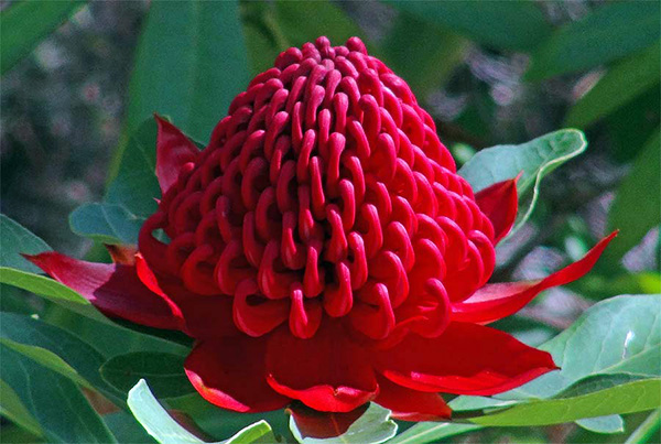
WA—abbreviation for the state, Western Australia. waagal—alternative spelling of wagyl. Waanyi—in Waanyi country in north-west Queensland the physical landscape is dominated by a series of rivers that have carved deep gorges covering an area of over 100km. Along these gorges and escarpments hundreds of archaeological sites occur. Layered onto this physical landscape is the symbolic landscape of Waanyi Wangalla stories, often passing down these same gorges. To the archaeologist this is a landscape of deep antiquity, evidence of occupation during the Last Glacial Maximum. To the Waanyi this is the landscape of the rainbow serpent, or Boodjamulla, who created the rivers and whose image has been left by ancestors as a reminder. The Waanyi community's traditional home borders the Gulf of Carpentaria, including Riversleigh, a semi-arid area of limestone outcrops that has yielded some of Australia's most important fossil finds. Waatgin—variant spelling of Watjin. wack—crazy, zany, irrational, peculiar, eccentric or amusing person. wacker—(see: wack). Waddaman—alt. spelling of Wagiman. waddy—an Aboriginal war club. The name comes from the Dhar Aborigines of Port Jackson, Sydney. A waddy is a heavy club constructed of carved timber. Waddies have been used in hand-to-hand combat, and were capable of splitting a shield, and killing or stunning prey. In addition to this they could be employed as a projectile as well as used to make fire and make ochre. They found further use in punishing those who broke Aboriginal law. They were made by both men and women and could be painted or left unpainted. Their construction varied from tribe to tribe, but they were generally about one metre in length and sometimes had a stone head attached with bees wax and string. They were made from where a branch met the tree, or from a young tree pulled up with its roots from the ground. Waddy has also been spelled as wadi, wady, and waddie. The spelling stabilised around the mid-nineteenth century, partly to help distinguish it from the Arabic word wadi, a dry water course. waddy wood—Acacia peuce, a tree up to 18m high, usually with short horizontal branches and pendulous branchlets. This species is distinctive due to its habit (like a conifer or she-oak) and its large, flat, papery pods containing large, flat seeds. This species is known from three disjunct locations situated in south-western Queensland and south-eastern Northern Territory, on the western and eastern edges of the Simpson Desert. Locally dominant on stony flats or gibber plains areas between longitudinal dunes or on alluvial flats between ephemeral watercourses. The southern populations occur on fixed, shallow sand aprons over clay and gibber slopes associated with denuded mesas. In the Boulia area, the species is associated with alluvium and paleochannels (ancient river beds) of the Hamilton and Georgina Rivers. Aboriginal people used the wood for making waddies. wadgula—(in Aboriginal English) a white person. Wadi Wadi—an Aboriginal tribe whose traditional lands lie within the Illawarra district of New South Wales. Also, their extinct language. Wadjarri—one of three clans gaining native title over nearly 48,000sq km of mainly pastoral country south of the Pilbara region in South Australia. In 2012 the Wadjarri People launched a dictionary to share and celebrate one of the world's oldest living languages. The Wadjarri Language Dictionary, which has taken over 25 years to compile, was launched on Wadjarri country at the Murchison Shire Settlement. Elders, community members, members of parliament, community groups, schools and government organisations attended the event. Language is an important part of culture and identity, but many Indigenous languages have been lost or are in danger of being forgotten. This dictionary will help keep Wadjarri culture and language strong for generations to come. The production of the dictionary was a joint partnership between the Yamaji Language Centre and the Bundiyarra Irra Wangga Language Program. waffle—1. nonsense; foolish, empty talk: e.g., His speech was a lot of waffle. 2. indulge in aimless, vague and lengthy talk or writing. wag—1. a humorous, amusing person; practical joker. 2. (of children) to wilfully be absent from school; play truant. Waga-Waga—Aboriginal people from the area just west of Brisbane, Qld. Wagait—Wagait country lies south-west across the bay from Palmerston, on Cox’s Peninsula and southwards along the coast of the Northern Territory. Members of this group began visiting Palmerston during the late 1870s. This brought them into occasional conflict with the Larrakia, although the two groups supported each other in conflict against the Djerimanga. During 1882 for example, Wagait men joined the Larrakia in attacking the Djerimanga in Palmerston itself, before Foelsche intervened, convincing them to fight outside the town. Wagga blanket—an improvised covering, usually of sacking. wagga pot/bell—a cattle bell. Wagga Wagga—Wagga Wagga (informally called Wagga) is a city in New South Wales. Straddling the Murrumbidgee River, and with an urban population of 46,913 people, Wagga Wagga is the state's largest inland city, as well as an important agricultural, military, and transport hub of Australia. The city is located midway between the two largest cities in Australia, Sydney and Melbourne, and is the major regional centre for the Riverina and South West Slopes regions. The city is located in an alluvial valley and much of the city has a problem with urban salinity. The original inhabitants of the Wagga Wagga region were the Wiradjuri people. In 1829, Charles Sturt became the first European explorer to visit the future site of the city. Squatters arrived soon after, leading to conflict with the indigenous inhabitants. The town, positioned on the site of a ford across the Murrumbidgee, was surveyed and gazetted as a village in 1849 and the town grew quickly after. In 1870, the town was gazetted as a municipality. During the negotiations leading to the federation of the Australian colonies, Wagga Wagga was a contender for the site of the capital for the new nation. During World War I the town was the starting point for the Kangaroo recruitment march. The Great Depression and the resulting hardship saw Wagga Wagga become the centre of a secession movement for the Riverina region. Wagga Wagga became a garrison town during World War II with the establishment of a military base at Kapooka and Royal Australian Air Force bases at Forest Hill and Uranquinty. After the war, Wagga Wagga was proclaimed as a city in 1946 and new suburbs were developed to the south of the city. In 1982 the city was amalgamated with the neighbouring Kyeamba and Mitchell Shires to form the City of Wagga Wagga local government area. Wagiman—an Aboriginal language spoken in the Northern Territory. Wagiman belongs to what linguists call the non-Pama-Nyungan language family. Within that family, it appears to fall into the Gunwinyguan language group, but it is not closely related to any other Aboriginal languages. There are several dialects of Wagiman, with the most prominent distinction being between matjjin no-roh-ma 'light language' and matjjin gu-nawutj-jan 'heavy language'. There is not all that much difference, and no Wagiman speaker has any trouble understanding another. Today, there are about ten people left who speak Wagiman, mostly old people. Wagiman country is large and well-watered, extending south-west from Pine Creek, and spanning the Daly River, which the Wagiman call Guwardagun. Before European settlement, there were perhaps about five hundred to a thousand people who spoke Wagiman. But a gold rush in Pine Creek in the 1880-90s, and then the pastoral industry, brought large numbers of immigrants to the area. Between about 1880 and 1920, new diseases introduced by Europeans, along with European violence and the introduction of alcohol, decimated the populations of all the language groups of Darwin and its hinterland. Since the 1920s, most Wagiman people have spent their lives working on the cattle stations of the area. The few fluent speakers of Wagiman sometimes use the language amongst themselves, but it is fairly rare to hear it spoken nowadays. Most Wagiman people now communicate in Kriol or Aboriginal English. wagyl—according to Noongar culture, a snakelike Dreamtime creature responsible for the creation of the Swan and Canning rivers and other waterways and landforms around present-day Perth and the south-west of Western Australia. The Rainbow Serpent, a superior being, created the universe and the people. It also delegated the wagyl as a lesser, but nonetheless powerful, deity to create and protect the rivers, lakes, springs and the wildlife. The Noongar people were, in turn, appointed as the guardians of the land by the wagyl. The wagyl was seen in visions by certain tribal elders who spoke to the Dreamtime being. The Darling Scarp is said to represent the body of the Wagyl, which meandered over the land creating the curves and contours of the hills and gullies. The being is strongly associated with rivers, lakes like Lake Monger, and is supposed still to reside deep beneath springs. As the wagyl slithered over the land, his track shaped the sand dunes, his body scoured out the course of the rivers; where he occasionally stopped for a rest, he created bays and lakes. Piles of rocks are said to be his droppings, and such sites are considered sacred. As he moved, his scales scraped off and become the forests and woodlands of the region. The Wagyl stories may represent the survival in oral tradition of extinct Australian megafauna, as there was a python-like snake, Wonambi naracoortensis, with a length of five or six metres. Wailwan—an Aboriginal people who inhabited the Coonamble / Gulargambone / Quambone region of NSW, and their language. wait-a-while—the climbing wild vine Acacia colletioides, with thorns that trap the clothing or skin of passers-by. Also known as lawyer bush. Waka Waka—an Aboriginal tribe of inland Queensland that inhabited an area from the upper Burnett to upper Brisbane rivers. wakaleo—Wakaleo vanderleuri, a species of "marsupial lion" that lived in Australia during the Miocene (about 16 to 10 million years ago). A marsupial, its closest living relatives are wombats and the koala. This diprotodont is hypothesized to have been an omnivore, eating significant amounts of meat, perhaps more like a bear in diet and habit than like an actual lion. It lacked large canine-like fangs, producing some controversy regarding just how much it actually preyed on living animals. The meat-eating hypothesis is based largely upon the morphology of its molar teeth. The species is believed to have been able to hunt by leaping from trees onto its prey. The type species fossils were originally found in the Bullock Creek area in the Northern Territory. Walalkara and Watarru Indigenous Protected Areas—cover 700,000 and 1,280,000 hectares respectively on the Anangu Pitjanjatjara lands in the north-west of South Australia. Both areas lie in the Great Victorian Desert, the traditional lands of the Pitjantjatjara, Ngaanyatjarra and Yankunytjatjara Aboriginal peoples (locally known as Anangu) who have maintained a connection with the land for thousands of years. Walalkara falls within the Great Victoria Desert Bioregion and. Watarru also lies largely within the Great Victoria Desert Bioregion but also includes some of the Central Ranges Bioregion. Walalkara and Watarru are culturally and biologically significant areas containing some of the highest diversities of reptile species found anywhere in the world, and supporting populations of rare and endangered species. A number of species of conservation significance have been found on the IPAs, including mallee fowl, great desert skink and the marsupial mole. Traditional owners believe other species are likely to be present, including the sandhill dunnart, mulgara and bilby. Walpiri—alternate spelling of Warlpiri. waler—1. a horse bred in New South Wales and imported to India. 2. a light, Australian-bred horse. Walgalu—one of the two Aboriginal peoples who originally lived in the region now occupied by Canberra, and is officially recognised as the original indigenous Australian custodian of country. Steven Avery wrote in Aboriginal and European Encounter in the Canberra Region: a question of change and the archaeological record, "The Walgalu estate is located in the Namadji (Namadgi) region to the southwest of Queanbeyan". The language of the Walgalu was a form of Ngarigo.] According to Norman Tindale in his 1974 catalogue of Australian Aboriginal, the specific areas where Walgalu lived were: the headwaters of the Murrumbidgee, and Tumut rivers; at Kiandra; south to Tintaldra; north-east to near Queanbeyan. Parkes obtained some details from a Wiradjuri man at Brungle under the name Guramal or Gurmal. (These notes also apply in part to the Ngarigo). Both tribes were to him guarai, or hostile people. The Walgalu spent their summers in the Bogong Mountains south-east of Tumut. The Walgalu went as far as Kauwambal on the upper Murray River, between Mount Kosciuszko and Mount Cobberas. It can perhaps be assumed that they extended their bogong-gathering forays by following the highlands along the eastern border of Djilama-tang territory. Walhalla—a steep-sided mountain valley and an historic Gippsland town. In 1862 Edward Stringer found gold in the fast flowing creek, but it was the discovery of Cohens Reef—almost 2 miles long—that put the area on the map. Walhalla's Long Tunnel Mine, operating between 1865 and 1914, was Victoria's single most profitable mine. During its peak years of production (1885—1910), the town had a population of 4,000. Today’s population reside in a small cluster of cottages that cling to a hillside so steep that some of the cemetery graves were cut lengthways into the slope. walkabout—refers to a rite of passage during which male Aborigines would undergo a journey during adolescence and live in the wilderness for a period as long as six months. In this practice they would trace the paths, or "songlines", that their ancestors took, and imitate, in a fashion, their heroic deeds. Merriam-Webster, however, identifies the noun as a 1908 coinage referring to "a short period of wandering bush life engaged in by an Australian Aborigine as an occasional interruption of regular work", with the only mention of "spiritual journey" coming in a usage example from a latter-day travel writer. To white employers, this urge to depart without notice (and reappear just as suddenly) was seen as something inherent in the Aboriginal nature, but the reasons may be more mundane: workers who wanted or needed to attend a ceremony or visit relatives did not accept employers' control over such matters (especially since permission was generally hard to get). The term has passed into general Australian slang, meaning: A trek which has little or no goal other than admiring nature, and the personal satisfaction of walking around the middle of nowhere and making it home alive. Usually the recount of the trek is exaggerated to add extra excitement and thrill. As opposed to the Aboriginal traditional walkabout, these modern-day treks in actual fact are usually very dull. Walker, Fred—founder of the Kraft Walker Cheese Company of Australia, contributed greatly to the Australian economy by adding a new dimension to the Australian food industry, and laying the foundations for a strong, international company. He was responsible for the development of many products, including processed cheese. Walker provided the inspiration for a yeast extract product, which has given Australians a national icon—Vegemite. Wallabies—the Australian International Rugby Union team. wallaby—any of various marsupials of the family Macropodidae, smaller than kangaroos, and having large hind feet and long tails. wallaby grass—Austrodanthonia spp. (formerly Danthonia), several species of native grass that was prized by graziers at the turn of the century. Interest was supplanted by imported pasture grasses, which required added fertilizer (superphosphate). Wallaby grasses grow well under heavy grazing, and are not fertiliser-dependent for survival. They are also winter green, providing valuable forage in winter and early spring. Comparative tests indicate that wallaby grass is only slightly lower in dry matter production and quality than other introduced grasses. It is an Australian native grass with showy, silky white seedheads when in flower. This is a hardy, low maintenance grass which is highly drought tolerant, frost tolerant and copes with acid soils. Useful for pasture, ornamental landscaping, roadsides, golf course roughs or revegetation works. Wallace Line—Alfred Russel Wallace, the so-called father of animal geography, formulated his ideas on evolution by natural selection while observing and collecting wildlife in the islands of South East Asia. He was particularly impressed by the sudden difference in bird families he encountered when he sailed some twenty miles east of the island of Bali and landed on Lombok. On Bali the birds were clearly related to those of the larger islands of Java and Sumatra and mainland Malaysia. On Lombok the birds were clearly related to those of New Guinea and Australia. He marked the channel between Bali and Lombok as the divide between two great zoogeographic regions, the Oriental and Australian. In his honor this dividing line, which extends northward between Borneo and Sulawesi, is still referred to today as Wallace's Line. Other biogeographers have since put the boundary between the Oriental and Australian provinces in slightly different locations. As is true of most regions, the core areas of both provinces are clearly distinct, but things are a little fuzzy on the periphery. Thus some biogeographers recognize the island region between Java and New Guinea as a mixing zone and designate it Wallacea. Wallacea—the Wallace Line runs between Kalimantan (Borneo) and Sulawesi. The naturalist, Weber, was interested in how far Australian animals and plants spread into the Eurasian area. He noticed that he could draw a line between Sulawesi and Irian Jaya (the Indonesian part of New Guinea) and between Timor and Australia. To the west, the fauna is more than 50 percent Oriental, while to the east of the line, fauna is more than 50 percent Australian in origin. Today biogeographers think of the area between these lines more as a zone of transition, called Wallacea. Wallaga Lake—a drowned valley, having a water depth of 3—6 metres over most of its area. Deeper water is found just north of Merriman Island, at the lake's centre. Bottom sediment is principally mud in the deeper areas, sand along the eastern fringe, and a combination of sand and shell toward the entrance of Dignams Creek. The lake has small inputs of fresh water from a number of creeks. Piles of shells give evidence of continuous Aboriginal habitation over thousands of years, and the lake has an Indigenous Locality designation. Situated on the Sapphire Coast of New South Wales. Wallaga Lake National Park—situated on 1237 hectares and includes the south-western lake foreshores between Narira and Dignams Creek. Enter on foot (from the Princes Highways) or by boat. Access to the park is best undertaken by boat from Wallaga Lake. Camping grounds are at Bermagui and Wallaga Lake, where the fishing is renowned. No facilities or water are available. The park is Located 354km south of Sydney, 27km south of Narooma and 18kms north of Cobargo, in the Bega Valley Shire of New South Wales. Mount Dromedary (Gulaga) is visible in the background from everywhere in the park. Wallaman Falls—the largest single-drop waterfall in Australia, tumbling 305m through a rainbow-fringed cloud of mist to a large pool. It is part of the 124,000ha Lumholtz National Park, which protects a diversity of vegetation types, ranging from open eucalypt forest to dense rainforest. There are camping sites, picnic facilities and walking tracks including a 300m track to a lookout and a 2km track to the bottom of the falls. The track back to the top is steep in places and requires strong lungs and legs. These tracks have been maintained by Girringun rangers. The falls are 48km (30 miles) west of Ingham, Queensland, 35km of which is unsealed road. wallaroo—three species belonging to the genus Macropus. The common wallaroo is found throughout mainland Australia and has a preference for rocky hills and stony rises, where caves and rock ledges provide shelter from extremes of temperature. The black wallaroo, in contrast, is restricted to a small area of central and western Arnhem Land in the Northern Territory. The Antilopine wallaroo is found in the tropical monsoonal forests of Northern Australia, where it replaces the red and grey kangaroos. Wallarra—the main stopover point for people visiting the King’s Canyon in Watarrka National Park, which lies 100km to the west. wallop—1. thrash; beat; strike heavily. 2. a forceful impression. walloper—a policeman. walloping—1. a sound defeat or beating. 2. large, huge, very big. Walls of China—the most notable feature of the Lake Mungo lunette. The lunette consists of layer upon layer of sand and silt deposited over tens of thousands of years. Weathering created the rilled ridges and residuals that characterise the the area. The dislodged sand was picked up by the wind and heaped into huge, mobile dunes along the back of the lunette. This on-going erosion has also uncovered extensive Aboriginal objects, indicating a large population over an extended period of time in the past. The bones of gigantic animals (megafauna) that lived in the area many thousands of years ago have also been revealed. Examples include Genyornis newtoni, a flightless bird with legs as solid as those of a horse; the towering short-faced kangaroo, Procoptodon goliah; and the buffalo-sized Zygomatrurus trilobus. The Walls of China is one of the most famous lunettes in the Mungo National Park, rising 30m above the plain and running 30km around Lake Mungo's eastern shore. wallum—the shrub or tree of south-east Queensland and eastern New South Wales. wallum sedge frog—this stunning, bright green frog species is only known from coastal acid swamps, marshes and streams from Fraser Island, Queensland, to north-east New South Wales. wally—stupid, foolish person. Wally Grout—(rhyming slang) shout—one's turn to buy the round of drinks or bear the cost of something. Walpiri—an Aboriginal tribe of Central Australia, and their language. Walpole—a town established in 1930 through the Nornalup Land Settlement Scheme that was designed for city families hit by the Great Depression. Despite loneliness and hardship, the little settlement developed and grew to form the basis of the district as we know it today—a special place, nestling in the beauty of the Walpole-Nornalup National Park and providing a welcome aura of peace, tranquility and timelessness. Europeans have visited the area since 1831 and Pierre Bellanger at Nornalup established the first settlement in 1909. Located in Western Australia, Walpole is located an hour and a half drive from Albany in the east and Pemberton in the west. Walpole-Nornalup National Park—renowned for its natural beauty, world-class nature walks and four rare species of tree: the red, yellow and Rate's tingles, and the red-flowering gum. The forest of giant red tingle trees—with trunks of up to 20m in circumference—can be viewed from the 600m-long Tree Top Walk that rises almost 40m above the forest floor. In the south-west of the park, about 5000ha of bushland has been set aside for bushwalkers, and the Bibbulmun Track passes through the park. The Walpole-Nornalup National Park is situated 121km west of Albany in WA. waltzing matilda—1. (cap.) the unofficial national anthem of Australia, written by A.B. "Banjo" Patterson and set to the music of an old Scottish ballad. Its first public performance, made in 1895, was a hit. Even today, this song has the power to transform any mob of Aussies into loud-mouthed yobs—particularly when overseas—as they patriotically shout out whichever words they can remember. 2. a term which has survived from the days when trainee tradesmen had to live an itinerant life, plying their trade in town after town, for a certain set period. The term is thought to come from a German expression, Auf die Walz gehen, meaning 'to take to the road'. In Europe during the Middle Ages and in Germany even to this day, an apprentice could not secure his release until he had worked under masters from other towns. Those amongst the large number of German immigrants who did not settle the land took this custom to Australia. Here, this itinerant trek became known as a waltz; and the meagre possession plus tools of the trade were carried wrapped in a bedroll. Walyunga National Park—contains one of the largest known Aboriginal campsites around Perth. The area was used by the Nyoongar people until late last century, and archaeological evidence indicates that the area had been in use for more than 6000 years. The Swan River runs through the centre of the park, forming a string of pools along the valley floor in summer, and a raging torrent with a series of rapids in winter. The latter provides one of Australia's best white water canoeing courses and is part of the annual Avon Descent race each August. The park is just behind the Darling Scarp, spanning both sides of a steep valley. Located within the Darling Range of Western Australia, 37km north-east of Perth. wambenger—(see: red-tailed phascogale). Wanaruah—an Aboriginal clan of the Hunter Valley, NSW whose territory extended north to the Liverpool Range, south to Broke, east to the Barrington Range and west to the Merriwa Plateau. The Wanaruah favoured goannas as a food source, covering larger animals in hot ashes and stuffing them with grass. They also adopted burning-off practices as the new shoots which emerged after fire had attracted kangaroos, which they surrounded and killed with clubs and spears barbed with sharp stones. They also used stone axes made of hard volcanic rock bound to a wooden handle. Another food source was lerp, a sweet, edible waxy secretion found on eucalyptus leaves and produced by the young of the psyllid (an insect) for protection. Lacerations were covered with wet clay or chewed eucalyptus leaves. As ironbark is slow to burn, it was used as a transportable fire-stick, while stringybark was used to make a twine employed in fishing and basket-making. wandering albatross—having a wingspan of nearly 3.5m, it is the largest flying bird alive today. True to name, it wanders around the globe in southern latitudes, often following ships, and is found around all of Australia's southern coast. They live for up to 40 years, mate for life and rarely breed until nine years old. wandering whistling ducks—feed entirely in water, either diving up to depths of 10 feet, dabbling in shallow water, or taking seeds and flowerheads direct from aquatic plants. Feeding in flocks is quite usual. Water lilies, grasses and sedges, pondweeds and duckweed form a major part of the diet, and feeding takes place during both daytime and at night. It is thought that these ducks mate for life. Their courtship display is similar to that of swans. Fighting often takes place between the males, usually at the beginning of the wet season. Breeding occurs between December and May. The nest, which is a scrape in the ground, is usually not far from the water and sheltered by long grass, but often found in areas with little nest cover. The eggs are six to fourteen in number and are laid on a lining of grasses, no down are added. They are cream in colour and measure 51x37mm. Both male and female share the job of incubation for a period of 28 to 30 days. Wandjina—a set of all-powerful creation gods to tribes in the Kimberly region of Western Australia. Wallungunder, the big boss Wandjina, came down from the Milky Way during Dreamtime and created the earth and all its inhabitants. Then he took one look at those inhabitants and headed back home for reinforcements. This was going to be a tricky job. With the aid of the Dreamtime-Snake, the Wandjina descended and spent their Dreamtime creating, teaching and being god-like to the natives. These gods from the Milky Way were so powerful that they didn't need to speak. So they didn't bother to have mouths. They were definite good guys, and are still worshipped and respected to this day. Many ancient cave paintings still exist and show eerie creatures with large heads, huge black eyes and suspiciously spacesuit-like garments. In fact, they look just like Grey aliens from modern U.F.O. abduction scenarios. Strangely enough, in 1838, a sea captain discovered an amazing treasure trove of Aboriginal artistry, filled with powerful Wandjina cave pictures. His name was Captain Grey. wandoo—Eucalyptus wandoo, a tree with smooth bark throughout, white or yellow. The leaves are dull, green or grey-green, and the flowers are white or cream. Wandoo woodlands were once extensive throughout much of southern Western Australia, but have now been extensively cleared for dryland agriculture, and are poorly represented. Uses of wandoo timber, known for being strong and durable, have been mainly for heavy and light construction such as wharves, bridges, poles, sleepers and flooring. The bark and wood were harvested in the past because they contain commercial quantities of tannins. There has been a severe decline of wandoo woodlands. The reasons are unclear, as there are a number of contributing factors involved: reduced soil water, salinity and changed fire regimes seem to be involved. Wood boring and crown defoliation insects are important but are likely to be secondary causes. In February 2002, the West Australian government launched the "Wandoo Response Group" aiming at developing programs that improve the health of Eucalyptus wandoo and other wheatbelt woodland species. Also known as white gum. Wangal—(see: Cadigal-Wangal nation). Wangaratta—a regional capital of some 17,500 people located 233km north-east of Melbourne via the Hume Freeway and 150m above sea-level. It is also the northern starting point of the Great Alpine Road. Early settlement of Wangaratta dates back to the 1820s, shortly after explorers Hume and Hovell passed through the area. Major Thomas Mitchell also passed through the region in 1836 on his explorations of southern New South Wales and Victoria. The Ovens and King rivers wind through the eastern section of town, meeting at Wangaratta and leaving a number of lagoons and billabongs in their wake. The town took its name from the Wangaratta cattle station on the Ovens River, established in 1837 or 1838. In the early 1850s the settlement was almost deserted as people flocked to the new gold diggings but it soon began to prosper from the traffic to the Ovens goldfields and the subsequent demand for produce and fresh meat. In the years since World War II Wangaratta has become a prosperous business centre and the area around it is a major wine-producing region. It was declared a city in 1959. Prior to European settlement the area was occupied by the Pangerang people. The name derived from an Aboriginal term possibly meaning 'nesting place of cormorants'. Wangi Falls—one of the best swimming and picnicking spots in Litchfield National Park. Its campground is complete with hot showers, toilets, barbecues and a kiosk, and serves as a good base from which to explore the park. You can swim between May to October and watch the thundering waterfalls during the monsoon period. Wangkangurru—an Aboriginal people of the Simpson Desert, ranging over the southern desert in good seasons and falling back on a series of native wells or mikiri when the country dried out. The Wangkangurru left the desert voluntarily in 1901 and walked south to the Bethesda Lutheran Mission at Killalpaninna. wangim—Aboriginal word for the returning boomerang. wangler—a cheat or confidence trickster. wank—1. funny, odd, amusing or eccentric person. 2. a person who deceives, deludes himself by refusing to see the truth or reality. 3. a person given to unproductive activity. 4. behaviour that is egotistical: e.g., What a wank that speech was! 5. to masturbate. 6. self-indulgence; over-indulgence: e.g., Having the conference in Hawaii was a bit of a wank. wanker—(see: wank, 1, 2 and 3). want (one's) head read—to show a need for psychiatric help; exhibit foolish tendencies, thoughts, actions. want to talk to the butcher, not the block—1. derisive remark to one who butts in, interferes, offers unwanted advice. 2. to insist on seeing the boss or person in charge. war cry—group or political party catchword or slogan. war service home—a home purchased under a scheme providing assistance to returned services personnel or their dependants. warabi—(see: short-eared rock-wallaby). Warakurna—a remote community situated in the Ngaanyatjarra lands on the Great Central Road, Western Australia, near the Northern Territory border, approximately 330km west of Uluru. The township of approximately 180 people is located next to the Giles meteorological weather station, and is nestled amongst the spectacular Rawlinson Ranges. Warakurna has a long history of artistic expression. Early in 2004 the community was assisted by Ngaanyatjarra Regional Arts to develop its own art centre. After many months of planning and hard work, Warakurna Artists Aboriginal Corporation was established. In March 2005, the art centre was opened amid much enthusiasm and excitement. It is the newest such development in the Ngaanyatjarra region and is fully owned and governed by Aboriginal people. It also services and represents artists from the nearby communities of Tjurla and Wanarn. Warakurna Artists is where men and women, young and old, paint and share Tjurpa (dreaming stories) and contemporary tales. The paintings are vibrant and diverse, reflecting each artist's unique style, stories and connection to country. Passing on these important stories to young people is a critical means of keeping culture strong and vital. Waramiri—an Aboriginal people of the Northern Territory. Warangesda Mission—operated between 1885 and 1924 and had a layout that seems typical of missions of the period. A church and assembly ground in the centre were surrounded by the manager's house, teacher's house, school room, ration store and fences. Rows of small, timber-frame houses marked the edges of the settlement. As well as these weatherboard and corrugated iron-clad houses, there were dormitories for single girls and boys. Some of the houses had small, fenced yards and water tanks and were furnished with government-issue items such as iron bedsteads. Beyond the formal station there were peripheral camps, usually temporary with canvas tents and bough shelters. waratah—Telopea speciosissima; the Aboriginal name for the species, waratah, was adopted by early settlers at Port Jackson. Telopea is an eastern Australian genus of four species. Two are confined to New South Wales, one to Tasmania and one extends from eastern Victoria into New South Wales. Telopea belongs to the family, Proteaceae, which is predominantly Australian and southern African in distribution, and includes genera such as Grevillea, Banksia, Macadamia and Hakea. The waratah is a stout, erect shrub which may grow to 4m. The dark green, leathery leaves, 13cm—25cm in length, are arranged alternately and tend to be coarsely toothed. The flowers are grouped in rounded heads 7cm to 10cm in diameter, surrounded by crimson bracts. It flowers from September to November and nectar-seeking birds act as pollinators. Large, winged seeds are released when the brown, leathery pods split along one side. The species is fairly widespread on the central coast and adjoining mountains of New South Wales, occurring from the Gibraltar Range, north of Sydney, to Conjola in the south. It grows mainly in the shrub understorey in open forest developed on sandstone and adjoining volcanic formations, from sea level to above 1000m in the Blue Mountains. Soils within its range tend to be sandy and low in plant nutrients. Rainfall is moderately high. Waratah plants resist destruction by bushfires, a natural element of their habitat, by regenerating from the rootstock. Flowering recommences two years after a moderate fire. The waratah is the floral emblem of New South Wales. Warburton—an Aboriginal settlement situated approximately 1500km from Perth by road, travelling via Kalgoorlie, Leonora and Laverton on the Great Central Road. Warburton is a desert area between the Gibson to the north-west and the Great Victoria Desert to the south-east. By the mid 1960s the effects of the long drought and the clearing of the Woomera rocket range for the firing of the Blue-Streak rocket had brought 400-500 Aborigines to reside at Warburton. The present settlement is situated in the valley between the Warburton and Brown Ranges, approximately 8km from the base of the Warburton Range. The burden imposed by this large population congregated in one small area began to be relieved when the Docker River settlement in the Peterman Ranges was opened in 1968. In 1973 an Aboriginal council was formed and incorporated at Warburton (Ngaanyatjara), and the Warburton community took over the administration of their own lands. Located in the Central Reserves region of Western Australia. Warburton, Colonel Peter Egerton—already 60 years old, and a veteran of the Indian Army, together with John W. Lewis, left from Alice Springs on 15 April, 1873. He would leave his expedition at a drinking hole until guides had found the next one, and in one case this meant staying in place for 6 weeks. Three of his camels died in the heat and drought, and were eaten, including head, tail, legs and hide. Although he intended to cross to Perth, lack of drinking water forced him to choose a much more northerly course, and he crossed the Great Sandy Desert to the Oakover River. Lewis and some of the stronger men rode ahead to an outstation to get some food for the weaker members of the expedition, including Warburton himself, who was ill and dying. The group that had remained back had already killed and eaten their last camel when Lewis came back with the valuable extra provisions. The expedition then followed the Oakover to the coast and reached Roeburne. warby—shabby, decrepit. Wardaman—an Aboriginal tribe of the Katherine region, and their language. Wardaman country lies to the south-west of Katherine in the Northern Territory, covering the area from Scott Creek and Flora River in the north to the Victoria River in the south-west. Most Wardaman people now live in and around Katherine, though a few have recently moved back to their traditional country. wardrobe—a large movable or built-in cupboard with rails, shelves, hooks, etc, for storing clothes; i.e. a clothes closet. Warlpiri—a group of Indigenous Australians, many of whom speak the Warlpiri language. There are 5,000-6,000 Warlpiri, living mostly in a few towns and settlements scattered throughout their traditional land in the Northern Territory, north and west of Alice Springs. Their largest community is at Yuendumu and many live also at Willowra, Lajamanu, Nyirrpi, Mount Allen and smaller settlements. Many also live in Alice Springs and Tennant Creek. About 3,000 still speak the Warlpiri language. Warlpiri people first came into contact with non-Aboriginal Australia in the late nineteenth century. By the time that the Warlpiri people were finally brought out from the bushland, the missionary movement was coming to an end, to be replaced by the community movement that would give Warlpiri people a permanent homeland. With the later outstation movement of the 1980s and 1990s many Warlpiri people moved out to small communities where they could be close to their own traditional land. At this time small communities such as Nyirrpi were set up. Warlpiri country is located in the Tanami Desert, east of the NT-WA border, west of the Stuart Highway and Tennant Creek, and north-west of Alice Springs. The main communities in Warlpiri country are: Yuendumu, Lajamanu, Nyirrpi, and Willowra. Many Warlpiri live in Alice Springs, Tennant Creek, and the smaller towns of Central Australia. Warlpiri are famous for their tribal dances. Warlpiris divide their relatives, and by extension the entire population, into eight named groups or subsections. These subsections are related to kinship, and determine one's family rights and obligations. Traditionally, the first thing one Warlpiri wants to know about another is their subsection. Warlpiris often address each other by subsection name rather than by personal name, and incorporate their subsection name into their English one, usually as a middle name. When Warlpiris marry Europeans, they tend to extend the subsection system to their in-laws, starting with the assumption that the European spouse is of the correct subsection. Rather distant European relatives may find themselves classified as honorary uncles, nieces, grandparents, and so on. Warlpiris will then try to make sure that further marriages with related Europeans will adhere to the marriage constraint. The traditional taboo against familiarity between a man and his mother-in-law extends automatically to any man and woman whose subsections are those of man and mother-in-law. The subsection system automatically prevents incest between siblings and any relatives closer than cousins. Cousins that are children of classificatory siblings (who may, by definition, also happen to be true siblings) of the same sex are themselves classificatory siblings, and may not marry; but children of classificatory siblings of the opposite sex are of the appropriate subsections for marriage, and marriage between so-called cross cousins is actually encouraged in traditional society. It should be noted that where a couple are not merely classificatory cross-cousins but are true cross-cousins (i.e. their parents are actual siblings), marriage is generally frowned upon. The Warlpiri language is a member of the group known as the Yapa languages, the name Yapa coming from the word for 'Aboriginal person' in most of the languages, its closest relative being Warlmanpa. Most Warlpiri-speakers are bilingual with English. Many also speak one or more of: Arrernte, Jaru, Western Desert Language, Warumungu, or other neighboring languages. Indigenous sign language is also an important component of Warlpiri communication; all of these languages had highly developed sign forms. The word "Warlpiri" has also been spelled as Walpiri, Walbiri, Elpira, Ilpara and Wailbri. warm temperate rainforest—found on poorer soils consisting of rocks such as rhyolite, trachyte and slates in the Tweed (Wollumbin) Volcano region; and on the more fertile eutrophic rocks in southern, cooler regions. To be classified as a warm temperate rainforest requires rainfall over 1300mm per year, and that the rainforest be distinguished by a two-strata layer which creates a relatively even canopy. Only 3 to 15 species will be evident, with stranglers, palms, woody vines and buttressing rare or absent. The tree trunks tend to be slender and uniform in appearance with distinct, circular-shaped communities of whitish lichens covering the bark. Tree and ground ferns are frequent, and epiphytes can be common but are not generally abundant in the numbers or species present. The most common trees are species such as coachwood, sassafras and scentless rosewood. Although warm temperate rainforest is predominant in the parks south of Coffs Harbour, examples can be found in all the World Heritage national parks of the Tweed (Wollumbin) Volcano region between 450m to 1200n, with major stands to be found in the Border Ranges and Mount Warning National Parks.
|