| Search JoyZine with Google Site Search! |
Australia Decoded
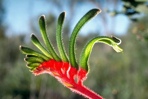
'k—kilometre: e.g., The next town is about fifty k's away. k's—1. kilometres: e.g., How many k's is it to Melbourne? 2. kilometres per hour. Kajabbi—a tiny settlement with a population of around 30, Kajabbi is located 118km north-east of Mount Isa and 100km north-west of Cloncurry. Mining relics, including smelter stacks, are still to be found at the sites of the former Dobbyn and Mount Cuthbert copper mines. The nearby mines at attracted miners to the area and, as a railhead in the 1920s, it was a location where the cattle owners from Queensland's far north-west brought their herds for shipment to the coast. Kajabbi is famous for the town's only pub, the Kalkadoon Hotel. The warrior Kalkadoon tribe, after whom the local hotel is named, had their last battle against mounted troops on the slopes of nearby Battle Mountain, and a memorial to the Kalkadoon tribes is situated opposite the hotel. Kakadu—an Aboriginal Reserve and the largest terrestrial national park in Australia. It comprises almost 8000 square miles of spectacular wildlife habitat, which ranges from the high stone plateau to forest woodland, monsoon rainforest to open, savannah-like flood plains dotted with billabongs; mangrove-fringed estuaries to coastal beaches of the Arafura Sea. At the heart of Kakadu is the South Alligator River. All life in the park depends on the seasonal monsoon to provide the year's quota of water. One thousand species of flora, 30 mammals, 75 reptiles, 1500 butterflies and moths, 50 freshwater fish and 25 species of frog have been discovered in Kakadu. Archaeological evidence suggest that humans have lived in the Kakadu region continuously from around 50,000 years ago, the earliest date that humans are known to have arrived in Australia. Renowned rock formations, including Ubirr and Nourlangie Rock, feature extensive galleries of paintings bearing a record of continuing Aboriginal culture over tens of thousands of years. The name 'Kakadu' is derived from 'Gagudju', the main Aboriginal language used at the start of the 20th century. Today, Aboriginal people from three major language groups—Gundjeihmi/Mayali, Kunwinjku and Jawoyn—live within the park. Kakadu is located at the northern fringe of the Northern Territory. Kakadu Aboriginal Land Trust—the owner of land in the Northern Territory, being N.T. Portion 1641, Part of N.T. Portion 1162 and N.T. Portion 1663. These parcels of land combine to comprise most of Stage One of Kakadu National Park. Aboriginal land trusts are constituted under the Aboriginal Land Rights (Northern Territory) Act 1976 (Commonwealth legislation). Under the Act, where land is granted following a traditional land claim, the title is held by an Aboriginal Land Trust. Kakadu escarpment—140 million years ago, much of Kakadu was under a shallow sea. The prominent escarpment wall formed sea cliffs, and the Arnhem Land plateau formed a flat land above the sea. Today, the escarpment rises to 330 metres above the plains and extends over 500 kilometres along the eastern boundary of the park. It varies from vertical cliffs in the Jim Jim Falls area to stepped cliffs and isolated outliers in the north. The escarpment is formed from layers of sandstone that were subsequently scoured and eroded to form gorges that now contain rainforests. Here can be found some extraordinary galleries of Aboriginal art, with rock sites dating back 25,000 years. Kakadu National Park—an outstanding example representing significant ongoing geological processes particularly associated with the effects of sea level change in northern Australia, biological evolution and people's interaction with their natural environment. Kakadu is the largest terrestrial national park in Australia, comprising almost 8000sq mi of wildlife habitat that ranges from the high stone plateau to forest woodland, monsoon rainforest to open, savanna-like flood plains, and coastal beaches of the Arafura Sea. Joint management of the park began in 1978, when leases were executed with the Kakadu Aboriginal Land Trust. As the park increased in size, further leases were executed with the Jabila and Gunlom Aboriginal Land Trusts. The Bininj/Mungguy (Aboriginal) representation covers the geographic spread of Aboriginal people in the region as well as the major language groups. Kakadu plum—(see: billy goat plum). kakka—an undersized crustacean. kala-azar—a tropical disease caused by the parasitic protozoan Leishmania donovani, which is transmitted to man by sandflies .Kalamaia—an Aboriginal people of Western Australia. Kalbarri—a township located at the mouth of the Murchison River. The town supports a local fishing industry and serves as a tourist base for visitors to Kalbarri National Park. Kalbarri is located about 590km north of Perth in WA. Kalbarri National Park—186,096ha of spectacular scenery in Western Australia. Weathering has exposed the layers of the coastal cliffs that rise more than 100 metres above the ocean. These Tumblagooda sandstone walls were created 400 million years ago on the tidal flats of an ancient sea. Fossil tracks and sea fossils can be found in many places along the river. The Murchison River gorges cut through the sand plain for 150km, stretching from the highway to Kalbarri town. Numerous coastal gorges include the famed Island Rock and the Natural Arch, which are easily accessed. Kalbarri National Park is located 590km north of Perth. Kalgoorlie—site of the country's biggest gold rush, which began in 1893. Water was scarce, and had to be distilled from bores and dams and then transported by camel to the region. Men came in the thousands from all over the world, and hundreds of mining companies were floated to speculate on the rich reefs. Kalgoorlie in the 1890s was a town of canvas tents, hessian huts and galvanized iron sheds, with a population of about 11,000. In the space of a few years, the goldfields had become the economic and political centre of Western Australia. Since 1893, the Kalgoorlie gold deposits—dubbed the 'Golden Mile', and reputed to be the richest square mile in the world—have produced over 35,000,000 ounces (993.125 tonnes) of gold. Kalgoorlie is still a mining town, although it doesn’t produce as much as it did in the 1890s boom period. It has since grown into the regional city of Kalgoorlie-Boulder. Kalgoorlie-Boulder—a city of some 59,000 people, a service centre for other towns in the Goldfields and Northern Goldfields sub-regions, and the regional transport hub. The area was first explored in 1863 by HM Lefroy, with further expeditions led by CC Hunt during 1864-68. Both men were seeking pastoral land and rode over the gold-bearing earth oblivious to the riches below. It was not until the gold rushes of the north-west of the state declined that miners began to explore the tracks established by Hunt. The city is a key location for the transfer of mineral products from mines in the region, and the importation of processing re-agents and other supplies for the mining industry. The traditional landowners of the Kalgoorlie area are the Maduwangka people, and the name Kalgoorlie is said to mean "silky pear bush" in their language. Located 369km from Perth, by air travel. Kalkadoon—the tribe once inhabited the range of hills running in an arc from Selwyn to Mount Isa to Kajabbi. Few Aboriginal tribes struck back at the white invaders, notable exceptions being the Palmer River tribe and the Kalkadoons, who in 1884 charged down Battle Mountain near Kajabbi against the invader. A Kalkadoon fighting man in full dress was a fearsome sight—generally more than six feet tall and broad in proportion, with piled-up hair and a plume of emu or eagle-hawk feathers adding to his height. His face was either covered with or surrounded by a band of white feathers stuck on with dried blood. Bands of feathers decorated his arms and legs. He had a collection of spears ranging from a twelve-foot giant, which he used as a lance, to light throwing spears, tipped with fire-hardened wood and barbs. These, when thrown with a woomera, could go through a man at seventy yards. What chance had spear and boomerang against Urquhart's mounted troops with carbines? They were killed almost to a man (women and children included), a terrible reprisal for the spearing of cattle and the killing and eating of a few Europeans and Chinese. The last known Kalkadoon survivor, Tubbie Terrier, died in Cloncurry Hospital in 1930. The descendants of white settlers in the area say that the sounds of that massacre can still be heard when the moon is full, carried on the wind around Battle Mountain. Kalkaringi—a town on the Victoria River, set up about 8km from Dagaragu to service the nearby stations. Many Gurindji moved to Kalkaringi, and now both Kalkaringi and Dagaragu are home to the Gurindji. The general topography of the district consists of mainly flat plain broken by small hills and rocky outcrops. All local rivers drain into the Victoria River and vegetation ranges from saltbush desert flats to densely wooded areas within the pastoral properties of Wave Hill, Camfield, Mount Sanford, Pidgeon Hole and Montejinni. Kalkaringi is located 470km south-west of Katherine, in the Northern Territory. Kallaua—alternate spelling of Alawa. Kalumburu—the township is located in the far northern Kimberley and is a modern Aboriginal community. This community was originally established at Pago and known as the Drysdale River Mission but was relocated to the present Kalumburu township site in 1927. The church still owns and operates the mission grounds and school, whilst the Kalumburu community is run by the Kalumburu Aboriginal Corporation. Visitors are welcomed by the community and a number of services operate to enable you to enjoy your stay for an extended period if you wish. Like other areas along the Kimberley coast, Kalumburu was bombed by the Japanese in WWII. Together with the history of the mission and various relics and ruins around the area, there is much to see and do other than the obvious fishing and camping. Due to the increased popularity of 4WD vehicles and the allure of self-sufficient camp/drive holidays, visitor numbers have boomed in even the most remote areas of Australia's outback. Kalumburu is certainly less visited than the Mitchell Falls, however it is well known that the waters off the Kalumburu coast hold great bounties for fishermen. The extensive river crossings on the Kalumburu Road make travel impassable for much of the wet season, yet from around April the first tourists will start attempting to push through to the north. Generally most travellers come once conditions have begun to dry—usually towards the of end May. Kamilaroi—an Aboriginal people who have traditionally inhabited a large region of central-northern NSW, including the entire Namoi catchment, prior to colonisation. There were the usual conflicts over land, food, customs and the rape of black women but matters weren't helped by the Myall Creek Massacre and the murderous actions of Major Nunn's troop on the Namoi River. Both outrages occurred in 1838 as white settlement of the Barwon was beginning. Along with drought and economic recession, this conflict successfully slowed settlement until the introduction of the Native Police, whose tactics and firearms effectively quashed resistance by 1850. The Aborigines then retreated. Some returned to work as station hands. Today, there are 12 local land councils in the Namoi representing a population of approximately 4,500 as per the 1996 census. Kamilaroi people extend from the Liverpool Plains to Gwydir, and Walgett, Bingara and Quirindi. Kanak/Kanaka—a Pacific Islander, especially (formerly) one employed as an indentured labourer in the sugar and cotton industries of Queensland. Kanal gundidj—for thousands of years the Dergholm-Chetwynd area was inhabited by Aboriginal people of the Kanal gundidj clan. This was one of 37 clans belonging to the Jardwadjali language group, which once covered a large part of western Victoria. When European settlement began in the late 1830s, the traditional lifestyle and social and cultural structures of the Aborigines were profoundly affected and their numbers rapidly declined. Kandijwal—an Aboriginal community within the Mitchell River National Park, of which they are the traditional owners. kandosols—mostly well-drained, permeable soils—although some yellow and most grey forms have impeded subsoil drainage. They are common in all states except Victoria and Tasmania. Kandosols are used for extensive agriculture in the wheatbelt of southern New South Wales and south-west Western Australia. Most kandosols have low fertility and are susceptible to surface soil degradation such as hardsetting and crusting. Also known as red, yellow and grey earths; calcareous red earths. Kandyu—an Aboriginal people of Queensland. kanga—1. kangaroo. 2. (cap.) a jack-hammer. kanga cricket—a game of cricket with rules and equipment designed for young participants. kangaroo—any of the larger marsupials of the Macropodidae family, having short forelimbs, a heavily muscled tail for support and balance, long feet and powerful limbs, and a swift, bounding motion. This is the first and best-known borrowing of an Aboriginal word into English. In 1770, when Captain Cook was forced to make repairs to the Endeavour in north Queensland, he and his party saw a number of large marsupials. From the local Aborigines—the Guugu Yimidhir of Cooktown—Cook elicited kangaroo or kanguru as the name of one of the animals. When Europeans settled along the Darling River, the English word kangaroo was taken over into the Baagandji language (with the form gaanggurru) as the name for the introduced horse. In total there are 55 species of kangaroo, wallaby and wallaroo belonging to the family Macropodidae (from a Greek word meaning 'big feet'). They are all similar animals but differ in size and build, from the large red and grey kangaroos to the rabbit-sized rat kangaroo. Kangaroos often graze alongside sheep and cattle, and, because they have teeth in both upper and lower jaw, unlike sheep which have teeth in only the lower, they can crop grass more closely than can sheep. Kangaroos can also survive on poor quality grass and go without water for long periods. Excellent eyesight, a good sense of smell and large, flexible ears enable the kangaroo to quickly detect approaching danger. An alarmed kangaroo thumps the ground with its hind legs, rather like a rabbit does, to warn the rest of the mob. When feeding and moving slowly, kangaroos balance themselves on their small front legs and strong tail, swinging the large hindlegs forward. They then bring their arms and tail up to complete the second stage of the movement. In the breeding season, usually spring and early summer, rival male kangaroos rear up on their hind legs and box to compete for a female. A natural predator used to be the Tasmanian wolf, but which has become extinct. The dingo, a wild dog introduced into Australia, is the only enemy of the kangaroo, except for man. A large kangaroo is well able to fight off several dingos by rearing up on its tail and lashing out with its powerful hind feet. Full contact with one of these kicks can kill. However, a kangaroo has no defence against man and his gun. The loss of natural enemies, the creation of wide areas of grassland and the ability of the kangaroo to breed throughout most of the year has caused kangaroo numbers to increase to pest proportions. Farmers have erected thousands of kilometres of fencing to keep kangaroos off their pastures, but this is expensive and kangaroos can leap over or squeeze underneath fences. Many cause accidents as they bound across roads at night, colliding with cars. As a result, huge numbers of kangaroos are shot. kangaroo apple—Solanum laciniatum, a stout, rapid-growing plant with dark, fleshy stems growing 4 to 6 feet in a season; much-divided leaves, dark violet flowers, and fruits the size of a small plum, changing from green to yellow and red. They are traditional bush tucker, but were eaten only when soft-ripe and deep orange coloured. The name derives from the leaves, which are shaped rather like the track of a kangaroo's foot. kangaroo bar—a heavy metal bar across the front of a vehicle to prevent damage if it strikes a kangaroo or other beast on the road. kangaroo bush—1. punty. 2. sand-hill wattle. kangaroo dance—an Aboriginal dance in which the movements of a kangaroo are represented. kangaroo drive—an operation in which kangaroos are slaughtered. kangaroo feather—(in the war of 1914-18) an emu plume worn on the hats of the Australian Light Horse. kangaroo fence—a fence made to exclude kangaroos. kangaroo fern—Phymatosorus pustulatus, a species typically seen decorating the mossy trunks of rainforest trees such as myrtle-beech and southern sassafras. Found as far north as tropical Queensland. kangaroo fly—any small, intensely irritating fly. kangaroo grass—Themeda triandra, a tall (60cm-90cm), perennial, tussock grass, one of the most widely distributed grasses in Australia. it occurs on gently sloping valley floors on medium-textured red earth soils, on low hills and near creeks. It often grows in association with mulga, coolibah, red river gums and spinifex. Aboriginals in the tableland and high country of New South Wales collected the seed for grinding into flour for making damper. While very responsive to summer rain it does not withstand heavy grazing especially during flowering. It is tolerant of fire and can be burnt to produce a green firebreak around fence lines. Once a dominant tussock over wide areas of grassland and woodland, now frequently out-competed by introduced grasses. Kangaroo Island—Australia's third-largest island, located off the tip of the Fleurieu Peninsula, 120km south-west of Adelaide. With a 480km coastline of rugged cliffs and protected coves, the island's continuing isolation has ensured an abundance of wildlife. The island was discovered and explored by Matthew Flinders during his exploration of 1800-1802. He and his crew found the island densely inhabited with kangaroos, after having been four months without fresh provisions. Kangaroo Island echidna—one of five recognised subspecies of short-beaked echidna, it is found from sea level to the highest points on Kangaroo Island, including woodland, shrubland, heath, coastal dunes and tidal and freshwater swamps. kangaroo jack—a heavy-duty, lever-action jack. kangaroo paws—belong to the genus Anigozanthos, which has 11 species. The closely related black kangaroo paw is Macropidia fulginosa. Kangaroo paws occur naturally only in the south-west of Western Australia, but grow in a variety of habitats and soil types. The size, flower-stalk height and colour of the flowers varies between the species. The overall colour of the flowers is influenced by fine, coloured hairs which cover the flowers and, sometimes, part of the stalk. The flowers appear over spring and summer. Kangaroo River Nature Park—take the time to make the journey to Upper Kangaroo River and Flat Rock. At Barrengarry, turn into Upper River Road—this drive is approximately 34km round-trip from the village. You will drive past many of the dairy farms that line the river, as well as the escarpments surrounding the valley. The locality of Upper Kangaroo River was once home to many people, and even had its own primary school. Today it consists of a few houses, and the Upper River Community Hall (which can be hired out for events). Here you will also find picnic facilities and a unique wire suspension footbridge over the river. Located in New South Wales. kangaroo steamer—a dish made from kangaroo meat. kangaroo tick—any tick having the kangaroo or wallaby as host. Kangaroo Valley—a pastoral village lying between the Shoalhaven coast and the Southern Highlands, nestled between Cambewarra and Barrengarry Mountains. The area is characterised by a patchwork quilt of farms on rolling pastures, and the town was granted National Trust status in 1977. Hampton Bridge, spanning the Kangaroo River, is the oldest and most photographed suspension bridge in Australia. Kangaroo Valley is close to the beaches of the Shoalhaven, the historic village of Berrima, and Jervis Bay. Located on the south coast of New South Wales, twenty minutes west of Nowra. kangaroo vine—an evergreen climbing plant, Cissus antarctica, with tooth-edged leaves, grows in rainforests and damp gullies. Native grapes from the kangaroo vine were eaten by the Aborigines and the early settlers. They have a grape-like taste but can irritate the throat if eaten in large numbers. The larger stems, when cut into pieces and allowed to drain, produce drinking water. The grapes were sometimes made into jam by early settlers. Kangaroo Wells—one of three known fossil sites in the Northern Territory, the others being Alcoota and Bullock Creek. Located on Deep Well Station. kangaroo-hop—(of a car) jerky movement of a car due to uneven release of the clutch (or other fault). kangaroo-rat—any of the small macropodoids of the family Potoridae, including the bettong and the potoroo. Kanmantoo bioregion—temperate, well defined uplands of Cambrian and Late Proterozoic marine sediments, and a literalised surface becoming increasingly dissected northwards, with eucalypt open forests and woodlands and heaths on mottled yellow and ironstone gravelly duplex soils in the wetter areas, and peppermint box and drooping she-oak on shallow rocky soils in drier areas. Extensively cleared for agriculture. Located in New South Wales. Kanmantoo Fold Belt—rocks crop out in the north-west corner of New South Wales, extending from south of the Barrier Highway to north of Tibooburra. This belt includes Late Proterozoic to Early Palaeozoic deep water sediments, plus some volcanic and shallow marine to continental sedimentation during the Middle Cambrian to Early Ordovician, when the Delamerian Orogeny caused folding and metamorphism. Sedimentation and volcanism associated with the development of the adjacent Lachlan Fold Belt subsequently affected this region. The Kanmantoo Fold Belt behaved as a relatively stable cratonic block after the Alice Springs-Kanimblan Orogeny. (Carboniferous). kanooka—Kunzea ericoides (or mana, as it was mostly known until the 1930s) occurs in Australia and New Zealand. In Australia it occurs in South Australia, Victoria, New South Wales and Queensland, and these have been much confused in the recent past with the New Zealand species. Members of the kanooka complex are found throughout New Zealand, ranging from coastal scrub and sand dunes (where it may form a distinct forest type) through lowland and montane forest, with one member of the complex reaching elevations of 2000m above sea level. Kanooka often colonizes land recovering after a fire and is a critical part of the natural recovery of open disturbed ground to forest. With its small but abundant flowers it can colour a whole hillside white, almost giving the appearance of snow cover. The wood is very hard and although not durable in the ground it is used for wharf piles and tool handles. It is particularly popular as firewood, and burns with a great heat. In New Zealand, kanooka can grow to around 10m high. Manooka and kanooka are superficially similar species and are often confused with one another. The easiest way to tell the difference between them is to feel the foliage, kanooka leaves being soft, while manooka leaves are prickly. Also known as kana, white tea-tree or burgan. kapok bush—Cochloprerum fraseri, is deciduous in the dry season, from May to August, and has distinctive bright-yellow flowers. Its large, fragile pods are filled with a dense, soft, cotton-like material. karara—the shrub or small tree Acacia tetragonaphylla, which forms prickly thickets. Karijini National Park—(formerly Hamersley Range) National Park is the second largest national park in Western Australia. Situated just north of the Tropic of Capricorn, the park's climate can best be described as tropical semi-desert. A highly variable, mainly summer rainfall of 250–350mm, often associated with thunderstorms and cyclones, is accompanied by temperatures frequently topping 40 degrees Celsius. Karijini National Park protects many different wildlife habitats, landscapes, plants and animals of the Pilbara. Huge termite mounds are a feature of the landscape, and the rock piles of the rare pebble mound mouse may be found in spinifex country. In the north of the park small creeks hidden in the rolling hillsides—dry for most of the year—suddenly plunge into sheer-sided chasms up to 100m deep. These are the park's famous gorges. Rocks exposed at the gorges originated as fine-grained sediment which accumulated on an ancient sea floor 2500 million years ago. The gorges were eroded when a sharp drop in sea level caused the rivers to downcut rapidly—a process enhanced by the onset of a more arid climate, which depleted the protective vegetation cover on the valley sides. The park is the traditional home of the Banyjima, Kurrama and Innawonga Aboriginal people . The Banyjima name for the Hamersley Range is Karijini. Evidence of their early occupation dates back more than 20,000 years. During that period, Aboriginal land management practices such as 'fire stick farming', resulting in a diversity of vegetation types and stages of succession, have helped determine the nature of the plants and animals found in the park today. karkalla—Carpobrotus Carpobrotus rossii, also known as coastal pigface, a common creeper of the beaches, dunes and headlands. The flowers, purple with many petals, appear in summer. Koories of Victoria used the leaves as a salad or they were cooked and eaten with meat. The fruit was eaten raw. C. Wilhelmi wrote (1860), "Pressing the fruit between their fingers, they drop the luscious flesh into the mouth. During the karkalla season, which lasts from January until the end of summer, the natives lead a comparatively easy life." Juice from the leaves was used to relieve stings. karpe—1. the parasitic fig tree Ficus pleurocarpa, that bears edible fruit and has a bark formerly used by Aborigines as blankets. 2. the wood of this tree. Karraru—an Aboriginal people of South Australia. karri—Eucalyptus diversicolor, one of the world's tallest hardwood tree species. It is native only to the wetter areas of south-western Australia. Most karri grows between Manjimup and Denmark, with outlying populations found as far west as Margaret River and as far east as the Porongurup Range. However, its development is best in the Manjimup-Pemberton-Walpole area. Karri occurs in patches, often mixed with other forest trees to make up a mosaic of forest formations, interspersed with sedgelands and heathlands. Karri forest understorey is particularly soft and lush. The Warren, Beedelup and Brockman national parks preserve some of Western Australia's best karri forest scenery. karst formation—landforms created by solution of rock in which most of the drainage is by underground channels that may lead to the formation of caves. Usually refers to limestone karst, but it can occur in other rock types. Karumba—the southern port of the Arafura Basin, situated on the mouth of the Norman River in the Gulf of Carpentaria, and the centre of the Gulf's prawning industry. Part of the wetlands that extend inland for approximately 30km, the area consists of a series of meandering saltwater tidal estuaries, habitat of saltwater crocodiles and a vast array of bird species such as pelicans, brolgas and black swans. These wetlands are a resting area for migratory birds whose flight path to and from Asia and Australia passes over the Karumba wetlands. The Port of Karumba was once a refuelling and repair stop for the Empire Flying Boats that connected Sydney to Great Britain. During the war, this route was the only aerial connection Australia had with the rest of the world. Visited by the Macassan fleets from the Celebes prior to European discovery of Australia, the area is now the centre of the gulf's prawning and barramundi industries. Karumba Basin—the Gulf of Carpentaria is underlain by two basins, the Jurassic/ Cretaceous Carpentaria basin and the overlying Cenozoic Karumba basin. The Karumba basin is sediment starved; subsidence exceeds the rate of sediment accumulation. Kata Tjuta—"many heads" in the language of the traditional owners, is a group of more than 30 rounded, red, conglomerate masses of rock rising out of the desert plain in the Northern Territory. Some of the rocks are bunched close together with only narrow, precipitous crevices between. Others, rounded and polished by the wind, are spaced further apart. The highest is Mount Olga (1500 feet). Although they are quite close to each other Kata Tjuta and Uluru have quite different geological and human histories. Where Uluru is a sedimentary rock which has been tilted nearly 85°, Kata Tjuta has only been tilted some 20°, and they are made of a much coarser sediment and contain quite large pebbles of granite and basalt. Artistically, Kata Tjuta is noted for its engravings and its geometric rock piles, all of which are believed to have been created by the Spirit Ancestor during the Dreamtime, the time of creation. Katherine—an outback town on the main road between Darwin and Alice Springs. Katherine is at the crossroads for more than 36 different Aboriginal cultural groups. These first inhabitants of the area based their seasonal movement, and therefore the emergence of their culture, upon the Katherine River. Approximately 25% of the population of Katherine is today of Aboriginal descent. White settlement of the town of Katherine occurred in 1878 with the completion of the Overland Telegraph and the arrival of Alfred Giles, the first cattle pastoralist. Katherine is situated 317km south of Darwin in the Northern Territory. Katherine Gorge—a series of 13 gorges scoured into the sandstone by the action of the Katherine River. These gorges and the surrounding landscape have ceremonial significance to the local Jawoyn people, who are custodians of the Katherine Gorge (Nitmil) National Park. Located 29km from Katherine. The gorges of Nitmil National Park began 23 million years ago as torrents of water pouring along tiny cracks in the earth. The National Park is rich in Aboriginal art, with rock paintings representing the spiritual ‘dreaming’ of the Jawoyn people, the traditional owners of the land. More than 100 kilometres of walking tracks meander through the National Park, including a five-day trek to Edith Falls. Katherine Gorge (Nitmil) National Park—home to Edith Falls and to Katherine's star attraction, Katherine Gorge (Nitmil). This 3000sq km National Park provides more than 100km of walking tracks. These tracks begin at the Visitor Centre, and range in duration from one hour to five days. The Aboriginal name for this park is nitmil, meaning 'Cicada Dreaming'. Katherine region—mining has played a major role in the Katherine region. While beef and mining are still major players in the economy of Katherine, tourism has altered the economic emphasis of the town. The development of the RAAF Base at Tindal, situated 15km south of Katherine, began with the construction FA-18 fighter jet planes. The $241,000,000.00 construction phase has now shifted to a fully functional northern defence base. Total RAAF population, including families in the Katherine area, is currently 2,200. Future potential resides in development of the Delamere Bombing Range and the Bradshaw Range. The first European to pass through this country was Ludwig Leichhardt in 1844. Katherine River—beginning in the wild escarpment country of Arnhem Land, the river surges through 13 separate gorges scoured into the Arnhem Plateau before heading north-west to the tidal Daly River and the Timor Sea. To the local Aborigines it was the point where the traditional lands of the Jawoyan, Walpiri, Dagaman and Wardaman met. The Katherine River, after which the town and the nearby gorge take their names, was named by John McDouall Stuart when he passed through the area in 1862. Katoomba—the largest settlement and central attraction in the Blue Mountains. Blaxland, Wentworth and Lawson explored the area during their 1813 crossing of the Blue Mountains. A coal mine opened at Katoomba in 1879 and kerosene shale was being mined by 1885. The area developed a reputation for its beauty, and Katoomba grew as a holiday destination. The coal mine closed in the 1920s, but the railway to the mine remained open and is now a popular tourist attraction. The whole of the Blue Mountains became a commuter zone for greater Sydney with the electrification of the railway line in 1957. The town's name reputedly comes from a local Aboriginal word, godoomba, meaning 'water tumbling over a hill'. Katoomba Falls—a dramatic waterfall tumbles down the cliff while the sun reflects off the spray, creating hundreds of tiny rainbows. Small cascades also feature here, and lonely Orphan Rock stands nearby. All these natural wonders are visible from cliff-top lookouts in the Blue Mountains, New South Wales. Kattang—an Aboriginal people of the northern New South Wales coast. Kaurareg—the Muralug Archipelago is the home of the Kaurareg people who identify as an Aboriginal tribe. Their traditional country included the islands and the surrounding sea. Frequent visits were made to this area by people from other continental islands to the north, including Badu, Nagir and Moa as well as Aboriginal people from the mainland. In 1921 the Kaurareg people who were then living on Kiriri (Hammond Island) were forcibly moved to Moa Island to the north. Some Kaurareg continued to inhabit Ngarupai (Horn Island) and plans to remove them to Moa Island in the 1930s were resisted. The main Kaurareg settlements presently in the region are Kubin Village on Moa Island and Wasaga Village on Ngarupai. Kaurna—an Aboriginal people of South Australia. Kaytye—traditional owners of the Barrow Creek area in the Northern Territory. The Governor General delivered a deed of grant to the Thangkenharenge Aboriginal Land Trust on behalf of traditional owners at a ceremony at Barrow Creek Old Telegraph Station at 11am on 27 August 2002. The land concerned is an area of approximately 12.5sq km. Keartland, George Arthur—naturalist, born 11 June 1848 at Wellingborough, Northamptonshire, England. He was brought to Melbourne by his parents in 1850. By a childhood accident he was lamed for life. Nevertheless he developed a strong affinity with the outdoors and interest in shooting and nature. After some training as a photographer he completed an apprenticeship to a printer and became a compositor with the Age, where he was employed for over fifty years. He joined the Melbourne Typographical Society in 1871 and was twice president of the Australasian Typographical Union. In 1886 he attended his first meeting of the Field Naturalists' Club of Victoria and was immediately inspired to study all branches of natural history. Keartland became a field ornithologist of national standing on the Horn and Calvert expeditions. On the former, from Oodnadatta to the MacDonnell Ranges in May to August 1894, Keartland, as naturalist-collector, preserved some 200 bird-skins, representing 78 species including 5 previously undescribed. A. J. North, of the Australian Museum, Sydney, regarded the collection as the most important after Sturt's of 1839 for its information on species distribution. On the ill-fated Calvert expedition to north-west Australia in 1896-97, Keartland was again a naturalist-collector but had to abandon over 300 bird-skins including a 'new' and possibly still unknown pigeon, returning with 167 specimens of 59 species excluding nests and eggs. This significant collection was also accompanied by excellent field notes, including early details of the Night Parrot. His name is commemorated in Lichenostomus (Meliphaga) keartlandi, grey-headed (Keartland's) honeyeater, named by North from the Horn expedition collection, and in Keartlandia, a now synonymized generic name, created by Mathews, for the orange chat. The name Keartland Hills in Western Australia commemorates his part in the Calvert expedition as does the name Gardenia keartlandii for a plant collected near the Fitzroy River. Keartland honeyeater—the grey-headed honeyeater Lichenostomus keartlandi of inland Australia. keel—a flat-bottomed vessel, especially of the kind that was used for loading coal-ships. keel over—1. fall over; faint. 2. to die. keelback snake—Tropidonophis mairii (also known as freshwater snake) feeds on frogs and tadpoles and can eat cane toads without ill effects. It moves agilely over mud or aquatic vegetation. Its strong, muscular body flattens and its strongly keeled scales grip even a slippery surface and stop the snake sliding sideways. keelhaul—to reprimand, scold, berate severely. keep—a threat, either jocular or serious, that the matter or person will be dealt with at a later date: e.g., I won't deal with him right now, he'll keep! keep a weather eye open—be alert, on guard. keep in with (someone)—maintain one's good standing, friendship with: e.g., I'd like to keep in with him because he gives me a good discount on everything in his shop. keep nit—to act as a guard or sentinel for someone doing an illegal activity. keep on keeping on—persevere; persist. keep (one's) bib out—refrain from interfering, prying. keep (one's) chin up—maintain (one's) calm, reserve; refuse to become angry or hostile; remain sensible and practical. keep (one's) feet—manage not to fall. keep (one's) hand in—remain involved in; stay in practice. keep (one's) head down—remain inconspicuous in difficult or dangerous times. keep (one's) pecker up—remain cheerful, especially of a man. keep the pot boiling—agitate; maintain activity, argument, hostility. keep your wool!—don't lose your temper; stay calm. keet—lorikeet. kelly—1. a crow. 2. one whose behaviour is supposed to resemble that of Ned Kelly. Kelly, Ned—on a cold June morning, more than 100 years ago a bushranger called Ned Kelly fought his final battle. He was an outlaw who rode a horse, put on a suit of armour and fought police. Today, Ned Kelly is an Australian legend. Ned, the eldest of eight children, was born to Irish parents in Victoria in 1854. In defying authority, robbing the rich and by not taking any more lives the gang fitted the popular image of brave and bold bushrangers. In Melbourne gaol, on 11 November 1880 Ned Kelly was hanged. He was twenty-five years old. Today Ned is everywhere. His giant form welcomes visitors to what is still called Kelly Country, where every ten years the Glenrowan siege is reenacted. For some he's no more than a criminal but for others he continues to be seen as brave and daring and, a bit of a larrikin, someone distinctly Australian. kelpie—an Australian sheep or cattle dog. kempt—well groomed. Kennedy, Edmund—in 1848, as the Assistant-Surveyor of New South Wales, Edmund Kennedy led an expedition to explore Cape York Peninsula. In the previous year he had discovered the Thomson River and established that the Barcoo River was part of Cooper's Creek. Arriving at Rockingham Bay (north of Townsville) in May, Kennedy's party, after much privation and toil, reached Weymouth Bay, where they established a depot. Kennedy, with four others—Costigan, Dunn, Luff, and an Aboriginal guide, Jacky-Jacky—left this depot in an endeavour to reach Cape York, where a relief ship was expected. Kennedy and Jacky-Jacky continued north, after leaving the others at Shelburne Bay. Only Jacky-Jacky reached Cape York, as Kennedy was killed in a skirmish with Aboriginals. Jacky-Jacky guided the ship's relief party to Shelburne Bay, but Costigan, Dunn, and Luff had perished. At the Weymouth Bay depot, only two survivors were found. Kenny, Elizabeth—(1886-1952) born New South Wales, graduated St. Ursula's College, Australia, 1902. She became “Sister” Kenny as a first lieutenant nurse (1914-18) in the Australian army. While caring for poliomyelitis victims in her homeland, she developed a method using hot, moist applications in conjunction with passive exercise. She came to the United States in 1940 to demonstrate her techniques, which were used extensively with good results. She was coauthor with John F. Pohl of The Kenny Concept of Infantile Paralysis and Its Treatment (1942); with Martha Ostenso she wrote the autobiographical And They Shall Walk (1943). Kerang Lakes wetlands—one of the ten most important wetlands in the Murray-Darling Basin. This wetland system covers 9172ha. The wetlands have moderate waterbird diversity and are very important for mammals, reptiles and amphibians. Along with Barmah Forest, Kerang Lakes have the largest ibis rookeries in the world. The Kerang Lakes region, located in the north of Victoria to the west of Swan Hill, is listed with the Ramsar Convention as a wetland of international significance. kerb—British spelling of curb. kerfuffle—commotion; row; argument; upset. Kermadec, Captain Huon de—commander of L’Esperance, one of the ships captained by Admiral d’Entrecasteaux. The Huon River was named by Admiral d’Entrecasteaux in honour of Captain Huon de Kermadec. The name was later applied, by extension, to the Huon Valley and the Huon pine. kero—kerosene. kerosene bush—Asteraceae Ozothamnus hookeri is smelly when crushed. This is the most common shrub on dry plateaux, which are burnt with some frequency. The leaves are very small (1 or 2 mm and quite narrow), acute, overlapping and scarcely spreading. kerosene tree—Halfordia scleroxyla, the wood is very inflammable even in a green state, hence the name kerosene tree. Splinters of the wood cause festering when they penetrate the skin. When chewed or used to clean the teeth, as is the habit sometimes of men working in saw-mills, the splinters cause trouble with the gums. Also known as saffronheart. Kerrup-Jmara—the 'water' clan of the Gunditjmara tribe, and traditional owners of the Lake Condah area in the Western District of Victoria. The clan retained their habitation of Lake Condah, following European settlement in the 1850s, by working for the squatters. The area was handed back to its traditional owners in 1987, under the Aboriginal Lands (Lake Condah and Framlingham Forest) Act 1987 (Cth), and is now managed by the Kerrup-Jmara Elders Aboriginal Corporation. Kerrup-Jmara Elders Aboriginal Corporation—a governing body invested with the power to make by-laws and regulations for the Lake Condah Aboriginal land. The Commonwealth Aboriginal Lands (Lake Condah and Framlingham Forest) Act vests 55 acres of land in the Lake Condah area in the corporation. A further three farming properties were purchased with a grant of $1.5m made by the Victorian government to the Kerrup-Jmara Elders Corporation. In following years, the Victorian government purchased two additional properties for the Corporation—Allambie and Muldoon’s—both of which border on Mount Eccles National Park. kharsi—toilet; dunny. khyber/Khyber Pass—(rhyming slang) arse; bum. kibble—1. grind coarsely. 2. an iron hoisting-bucket used in mines. kibosh—rubbish; nonsense. kick—1. thrill; temporary enthusiasm, excitement or pleasure. 2. the sharp, stimulating effect of alcohol or drugs. 3. buying of a round of drinks (or other); shout: e.g., It must be his kick because I shouted the last round! 4. funds; petty savings: e.g., I put a few dollars in the kick every week for Chrissy. 5. the trouser pocket: e.g., Put that money back in your kick, I'll pay for this round. 6. complaint or objection: e.g., What's his kick? kick against the pricks—persist in futile effort. kick around with—associate with; be in constant company with: e.g., He kicks around with some tough-looking characters. kick him where his mother never kissed him—kick him in the bum or genitals. kick in—contribute or donate money to a common cause: e.g., We're all kicking in a few dollars for a pressie for his retirement. kick off—1. to die. 2. commence, begin. kick on—to continue having a good time long after most people have left: e.g., We kicked on till dawn. kick over—finish; complete: e.g., We should kick that job over in a day. kick the eye out of a needle—(of a horse) wild, unruly and given to kicking: e.g., That brumby would kick the eye out of a needle. kick the tin—1. pay for a round of drinks; shout. 2. donate, contribute money to a common cause. kick up the arse/bum/jumper/khyber/pants/quoit—1. severe incentive or encouragement: e.g., He needs a kick up the quoit every now and then. 2. severe discipline, scolding, reproach, beating, thrashing, punishment. kick-in—(Australian Rules football) return of football to play after a point. kick-over—an easy task; e.g., The exams were a kick-over. kicked from pillar to post—treated poorly; mistreated so as to go from one predicament to another: e.g., Since his parents split up, that child has been kicked from pillar to post. kicksorter—a device for analysing electrical pulses according to amplitude. kid-stakes—small; insignificant; trifling; unimportant. kiddiewink—young child. kill a brown dog—anything potent, deadly: e.g., Her cooking is bad enough to kill a brown dog! kill a snake—(of a man) urinate. kilogram—approximately 2.205 lbs in the metric system, which is used in Australia. kilojoules—a measure of the energy of food, used instead of calories. kilometre—a metric unit of measurement equal to approximately 0.62 miles, as used in Australia.
|