| Search JoyZine with Google Site Search! |
Australia Decoded
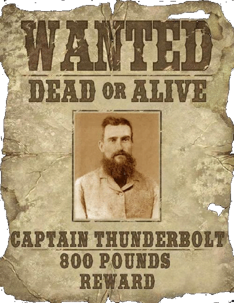
Cape Howe National Park—30km west of Albany, Western Australia. Habitats for wildlife in the area range from low heath and scrub on the infertile sand near the coast to low banksia forest, swampy areas, and tall karri and jarrah-marri forest. West Cape Howe contains some superb coastline and a great variety of plants. Swamp areas in the park form a habitat for the insect-eating Albany pitcher plant and many birds. Patches of karri forest, and granite and limestone cliffs are also features of the park. Cape Keerweer—was one of the first Australian places named in journals and on the charts of Dutch explorers from 1606. Its prosaic meaning, 'turn-again', typifies many later European place names. Along the sandy beaches in this area of Cape York, Aboriginal people first encountered Europeans, their firearms and their alcohol. For these reasons it symbolises the first recorded cultural contacts between Aborigines and Europeans. During these encounters the pattern of later racial relations was symbolically set with alcohol and sugar, and the betrayal of trust with treachery. The Aboriginal response was a determination to resist aggression, which is still celebrated in oral traditions of the area. The numerous Aboriginal sites on the peninsula are being systematically and comprehensively recorded in what promises to be a highly valuable database of not only Australian, but international significance. Cape Keerweer is an historic site of great importance in the history of race relations in Australia. Located in Far North Queensland. Cape Le Grand National Park—56km east of Esperance: rugged granite headland; beautiful bays such as Hellfire Bay, Thistle Cove and Lucky Bay. Within the south-western corner of the national park are a series of spectacular outcrops named Mount Le Grand, Frenchman's Peak and Mississippi Hill. Cape Le Grand is home to many unique species of native wildflowers and these can be seen in full bloom between September and November. Cape Leeuwin—the most south-western cape in Australia. The cape was named by Matthew Flinders for the Dutch ship, Leeuwin, which had sailed from Holland in 1621, making landfall in Australia in March 1622. Cape Leeuwin was again sighted by Matthew Flinders on 7 December 1801 while aboard HMS Investigator. Flinders surveyed and charted the entire south coast from Cape Leeuwin, and reached South Australian waters in January of 1802. Cape Leeuwin is located in Augusta, Western Australia. Cape Nelson Lighthouse—built in 1884 to assist ships sailing west, upon entering Bass Straight. The narrow western entry to the strait was the most treacherous part of the three-month voyage from Liverpool or London. It took just the slightest miscalculation after a very long trip from Africa to miss the twenty-nautical-mile gap between the Australian mainland and King Island to the south. The 32m tower stands atop 40m cliffs. The original telescope was described as the biggest of its kind in the Western District. It arrived on 29th May, 1885 and was used "to sweep the horizon a distance of 25 or 30 mile and scrutinise passing ships of hostile intent". Today, the light has a range of 22 nautical miles and its white light is approximately 850,000 candlepower. The light stands 75m above sea level and consists of a group flashing 4 times every 20 seconds. The lighthouse, which is located within the Cape Nelson State Park, near the city of Portland in Victoria, is a popular tourist destination. Cape Nelson State Park—a 243ha Marine and Coastal Park/Marine Reserve, 11km south-west of Portland, Victoria. Spectacular coastal cliffs, diverse bird life, picturesque walks and picnic areas. Apart from the rare soap mallee, Cape Nelson contains several vulnerable plant species, including coast ground-berry, mountain daisy, drooping velvet bush and bog sedge. The Cape Nelson Lighthouse is one of the popular attractions in the area, with spectacular views of the surrounding coastal and inland environment to be gained by climbing the tower, as well as a greater appreciation of our maritime history. It was built in 1884 to assist ships when entering Bass Straight. The Sea Cliff Nature Walk gives an introduction to the natural history of the area. You can watch sea and land birds, kangaroos, echidnas, snakes and lizards. Note the limestone overlying the basalt of rock platforms near sea level. Cape of Good Hope—a headland in South Africa, marking the turning point between the Atlantic Ocean and the Indian Ocean. The discovery of the Cape of Good Hope was made in the 15th century as a result of Portuguese exploration, thereby opening a route to India. The sea route to the East Indies (Asia) around the Cape of Good Hope allowed the Portuguese to bring spices directly from the markets of South East Asia to Europe. Portugal monopolised the spice trade for two hundred years, until the Cape of Good Hope was taken over by the Dutch East India Company in 1652. Cape Otway—a cape and a bounded locality of the Colac Otway Shire in southern Victoria, on the Great Ocean Road; much of the area is enclosed in the Great Otway National Park. The rugged cape presents some of the most dramatic coastal and rainforest scenery to be found anywhere on the Great Ocean Road. The Cape Otway Lighthouse, built in 1848, marks the dangerously narrow western entrance to Bass Strait. The Cape was discovered by Europeans when Lieutenant James Grant made the first west-to-east passage through Bass Straight in the Lady Nelson in December 1800. Grant named it Cape Albany Otway after Captain William Albany Otway, later shortened to Cape Otway. The government reserved the tip of the cape and opened the rest up to selection by settlers. Cape Otway was originally inhabited by the Gadubanud people; evidence of their campsites is contained in the middens throughout the region. They occupied the area for around 40,000 years before white settlement in the early 1800s displaced them and decimated their numbers. Dinosaurs roamed the Otway coast more than 105 million years ago, when Australia was much closer to the Antarctic. Palaeontologists have unearthed fossils of these "polar" dinosaurs at a site called Dinosaur Cove. The hostile seas surrounding Cape Otway, where the Southern Ocean meets with Bass Strait, are home to some of the worlds most prized marine species, including crayfish and abalone. It is common on calm days for there to be as many as 20 abalone dive boats operating along the shoreline beneath the lighthouse. Cape Otway Lighthouse—the oldest surviving lighthouse in mainland Australia. The light, which has been in continuous operation since 1848, is perched on towering sea cliffs where Bass Strait and the Southern Ocean collide. For thousands of immigrants, after many months at sea, Cape Otway was their first sight of land after leaving Europe. Eight ships were wrecked along the coast of Cape Otway, including the Marie (1851), Sacramento (1853), Schomberg (1856), Loch Ard (1878), Joseph H. Scammell (May 1891), Fiji (September 1891) and the Casino in 1932. Hundreds of lives were lost, which led to the building of the lightstation in the foothills of the impenetrable forests of the Otways. Access to the site was difficult; it was eventually reached overland, and construction of the Cape Otway Lightstation began in 1846 from stone quarried at the Parker River. It was the second lighthouse completed on mainland Australia. It was decommissioned in January 1994 after being the longest continuous operating light on the Australian mainland. A telegraph station was added to the site when Tasmania was connected to the mainland by a submarine telegraph line from Cape Otway to Launceston in 1859. The first American vessel sunk during World War II, the SS City of Rayville, was also sunk off the Cape by a German mine. Following this, the Americans built a radar bunker on the cape in 1942; it is now open to the public. The lightstation was decommissioned in January 1994 after being the longest continuous operating light on the Australian mainland. The lightstation precinct is the traditional home of the Gadabanud people. Discover more about this isolated but resourceful Aboriginal clan. Cape Paterson—a small seaside town located on the Bunurong Coast. The town was named in 1801 by Lt Grant to honour Lt. Col. William Paterson, second in command of the Botany Bay (Sydney) battalion. In 1826, black coal was discovered in an outcrop near Cape Paterson by the explorer William Hovell. Although investigated and worked over the next forty years, mining was never economically viable. Eventually, better coal seams were found north of Cape Paterson, at Wonthaggi. The coastline for seventeen kilometres east and west of Cape Paterson has been declared a marine and coastal park. Cape Paterson is located 10km south of Wonthaggi, Victoria. Cape Peron—(see: Point Peron). Cape Preston—a colliery site located 100km south of Dampier in Victoria. Black coal was first discovered at Cape Preston in 1825, but it was not until 1908 that drilling by the Department of Mines was undertaken. Located in the Pilbara. Cape Range—forms the spine of the peninsula that stretches up towards North West Cape in the Gascoyne region of Western Australia. The range was created 10 million years ago, when the north-west corner of Australia was covered by a warm, shallow sea which has left behind hard, fossil-bearing limestone that was laid down on the sea-floor. The rugged scenery of Cape Range passes from high plateau shrubland to deep ocean within a distance of only a few kilometres. This is the only elevated limestone range on the north-western coast of WA, with plateaus of up to 314m in height. Colourful wildflowers cover the cape from August through October. Cape Ranges National Park—comprises tranquil beaches, rugged ranges and magnificent canyons and is situated on the western side of the North West Cape. The Cape Range is a huge upward fold of limestone originally formed below the sea. Erosion of the limestone has gouged vast canyons in the sides of the range and subsequent deposition of the eroded material along each side has helped build up coastal plains. These have been modified over the ages by various processes such as wave action at times of higher sea levels and the formation of dunes made from wind-blown sand along the coast. A highlight of any visit to this park is Yardie Creek where deep-blue water, cut off from the sea by a sandbar on the coast, lies ensconced between vertical cliffs. Cape Range is rugged, devoid of drinking water, and prone to high temperatures from November to April. Even experienced bushwalkers have underestimated the harshness of this country and succumbed to exhaustion. Walking in summer can be dangerous as temperatures can reach as high as 40 to 50 degrees Celsius. Vegetation in the park includes mangroves, acacia, cassia, grevillea, eucalyptus, Verticordia, spinifex and minilya lily. Faunal specimens include rock wallaby, red kangaroo, euro, eighty species of reptiles and over one hundred species of birds. The Cape Range National Park hugs the western coast of the North West Cape, covering 50,831 hectares. Located 35km from the centre of Exmouth, in the Gascoyne. Cape Raoul—there are many cliff top walks on the Tasman Peninsula in and around Port Arthur, and Cape Raoul is one of the most spectacular in Australia. Nine kilometres past Port Arthur there is a turn left along Stormlea Road. Another 9km further on is a parking area for the Cape Raoul, Ship Stern Bay and Tunnel Bay walks. The road continues on for a few hundred metres to a small stile which crosses the fence. About 30 minutes walk across the side of a paddock and through light woodlands the track to Tunnel Bay and Ship Stern Bluff branches off to the right. Another 10 minutes further on brings you to the edge of a 300m-high cliff with commanding views of the coastline. The track then descends steadily onto the Cape Raoul plateau. The spectacular dolomite pillar cape is at the end of the plateau. Cape River fan palm—Livistona lanuginosa, a large fan palm, similar in appearance to L. mariae and L. rigida, and having very grey, waxy leaves. It has the largest fruit of any Australian Livistona, approximately 30mm in diameter. Very drought hardy. Found on the Cape River in north Queensland. Cape Schanck—named in 1801 after Captain John Schanck, the inventor of the sliding keel, by Lieutenant James Grant as he undertook the first full survey of the coastline after Bass and Flinders. Located within Mornington Peninsula National Park (previously Point Nepean National Park), on the southern tip of the Mornington Peninsula, Victoria. Cape Schanck Lighthouse—a navigational light on the entrance to Port Phillip Bay. Built in 1859, the Cape Schanck lighthouse is the second coastal light established in Victoria, and is also regarded as the best-preserved of the Australian lighthouses. The original clockwork mechanism is still in place, though the light is now turned by an electric motor. An unusual feature of this lighthouse is its stone stairway in place of the usual wrought iron. The tower was built from dressed limestone. The Cape Schanck lighthouse is part of a trio of historic Bass Strait lighthouses that were outfitted with radio-controlled lights and signals in 1939. The other two lighthouses are located at Cape Otway and Cape Wickham. Cape Schanck is located on the southern tip of the Mornington Peninsula, and the lighthouse is about a 90-minute drive from Melbourne. Cape Sorrell—site of a former Tasmanian penal colony. Cape Sorrell is located in Macquarie Harbour in the west of Tasmania at the mouth of the Gordon River. Cape Town—(hist.) a key supply port on the British route to the East in the late 18th century. Now included within the British Empire, the initial colony at Cape Town was founded in 1652 by to provide a way station where Dutch merchant ships could take on water and fresh foods along the journey from Europe to the East Indies. The British captured Cape Town during the wars precipitated by the French Revolution in the 1790s when Holland was overrun by France, thus making its colonies subject to British attack. The British held the colony during the Napoleonic conflicts that followed and annexed it permanently in 1815 as a vital link on the route to India. Cape Town, under British rule, was also used to supply convict ships on their way to New South Wales. Cape Tribulation—a scenic and popular coastal section of Daintree National Park, stretching between the Daintree and Bloomfield rivers. Cape Tribulation is part of the Wet Tropics World Heritage Area. Striking rainforest-clad, granite mountains rise over 1000m above the adjacent coastline. Fringing coral reefs and white sand beaches add to the scenic grandeur and diversity of the area. Roaring Meg Creek flows over a series of significant waterfalls before reaching the sea. Away from the coast, the land rises steeply to cloud-swept Thornton Peak. The park is renowned for its rich diversity of plants and wildlife with lowland and upland rainforests, mangroves, swamps and heathlands. Some of the world's most primitive flowering plants survive in these rainforests. Over 20 birds occur at their northern limit of the cape and many birds restricted to north Queensland rainforests are quite common in the area. Cape Tribulation was named by Captain Cook in 1770 after beaching HMB Endeavour on a coral reef during his expedition to chart and claim the coastline of terra australis incognita for the British Crown. Cape Wickham—site of the tallest lighthouse in the Southern Hemisphere. Cape Wickham is located on the northern end of King Island, in the Bass Strait. Cape Wickham lighthouse—the tallest lighthouse in the Southern Hemisphere, rising 48m above the northern tip of King Island. The Cape Wickham lighthouse was constructed from local granite in 1865, with the intention of warning ships away from the dangerous King Island coastline. Lighthouses are usually built to signal a point of safe-entry, so the one at Cape Wickham was distinguished by a constant, unblinking light. Nevertheless, many ship's captains mistook the Cape Wickham light for Cape Otway's, enticing them to sail straight into the coast. The danger only eased with the construction of the Currie lighthouse in 1879. The Cape Wickham lighthouse retains it original lantern house as well as its timber staircase, consisting of eleven flights of 20 steps each. Cape York birdwing—Ornithoptera priamus pronomus, Australia's largest butterfly. The females are larger, having a wingspan up to 20cm. Her wings are black and white with yellow spots along the margin of each hindwing. The body is yellow, with red under the thorax. The wings of the males are green and black with yellow spots along the margin of each hindwing. The body is yellow on top, and red under the thorax. They have a wingspan of up to 11cm. The caterpillar feeds on various members of the Aristolochiaceae family. The caterpillar pupates sometimes on a stem of the food plant, and sometimes elsewhere, having gone walkabout. In Australia, several races are recognised, including: macalpinei from around the Iron Range on Cape York, and pronomus from the tip of Cape York. Now a protected species, birdwing numbers have been reduced due to habitat destruction. Other races occur in Irian Jaya and in New Guinea, where it is farmed for sale to collectors. Cape York Land Council—an Aboriginal Corporation commonly referred to as simply the Land Council, it is incorporated under the Aboriginal Councils and Associations Act 1976 (Cwlth) and is recognised as a public benevolent institution for taxation purposes. The principal object of the Land Council is the relief of poverty, sickness, destitution, serious economic disadvantage, distress, suffering and misfortune of Aboriginal persons, communities and groups within Cape York Peninsula. The core responsibility of the Land Council is to assist Cape York Aboriginal people with matters affecting their traditional lands and seas, through the exercise of their legal rights under state and Commonwealth native title and land rights legislation. Cape York lily—Curcuma australasica, a spectacular member of the ginger family, and a close relative of the Asian Curcuma variety which produces tumeric. It's natural distribution is the tropical areas of Australia—Cape York, Arnhem Land and Thursday Island, where it grows as a perennial herb in dry scrub and margins of rainforests. The foliage, which can reach 1.5m high, dies back in the dry winter season, re-emerging from the underground rhizomes with the onset of the wetter spring/summer season. The annual rainfall is in the 1000mm—1500mm range, mostly in summer. The 15cm- to 25cm-long flower inflorescence usually precedes the new leaves in spring. It consists of rose pink bracts about 3cm—5cm long, shading back to green as they age, which enclose the small (1cm) yellow flowers. During the wet season, the ground is literally pink with the massed display of the Cape York lily. Cape York Peninsula—a region covering an area of approximately 150,000sq ha in Far North Queensland. This largely undisturbed ecosystem contains wetlands, riverine forests, tropical woodlands, tropical rainforests, dry rainforests, heathlands and dune fields. The numerous rivers are unregulated by dams and weirs, permitting the cycle of dry and wet that regenerates monsoonal areas. Around 8000 years ago, when the sea level was lower, Cape York formed a land bridge connecting the Australian mainland to Papua New Guinea. 16,000 years ago there was also a land link between Arnhem Land and PNG, and the Gulf of Carpentaria was an enormous, enclosed, freshwater lake. Many of the plants and animals on the cape can also be found in Papua New Guinea, while others have changed little since Australia was part of the super-continent Gondwana hundreds of millions years ago. Before European contact, Cape York Peninsula was one of the most densely populated areas on the Australian continent. Its rich and diverse environment supported a population of 40,000 people, who spoke about 45 major languages. Today, Indigenous people constitute two-thirds of the peninsula's population. Within the peninsula, there are seventeen Aboriginal communities, with a total population of 12,000. Cape York Peninsula has two significant landscapes: the Tip, and Cooktown and its environs (including Palmer River). Captain Willem Janzsoon in the ship Duyfken made the first European landing in Australia at Cape York, on the north-east Australian coast, in 1606. Cape York Peninsula bioregion—complex geology dominated by the Torres Strait Volcanics in the north, the metamorphic rocks and acid intrusive rocks of various ages of the Coen-Yambo Inlier, which runs north-south along the eastern margin of the region and encompasses the high-altitude/high-rainfall areas of Iron Range and McIlwraith Range. The deeply dissected sandstone plateaus and ranges of the Battle Camp Sandstones lie in the south of the region adjacent to the undulating Laura Lowlands, which are composed of residual weathered sands and flat plains of colluvial and alluvial clays, silts and sands. The west of the region is dominated in the south by the extensive Tertiary sand sheet dissected by intricate drainage systems of the Holroyd Plain, the Tertiary laterite of the undulating Weipa Plateau, the low rises of Mesozoic sandstones, with the northern extension of the Weipa Plateau and extensive coastal plains adjoining the Gulf of Carpentaria. Extensive aeolian dunefields lie in the east associated with Cape Bedford/Cape Flattery in the south and the Olive and Jardine Rivers. The vegetation is predominantly Darwin stringybark and carbeen/Clarkson's bloodwood woodlands, broad-leaved tea-tree woodlands, heathlands and sedgelands, notophyll vine forests, with semi-deciduous mesophyll vine forests on the eastern ranges and deciduous vine thickets on drier western slopes. Extensive mangrove forests are found in Kennedy Inlet in the north-east of the region and estuaries on both the west and east coasts. Tropical humid/maritime climate, with rainfall varying from 1000mm to 1600mm. Cape York rock-wallaby—Petrogale coenensis, a rock-wallaby species found on Cape York Peninsula, Far North Queensland. cappo—capitalist, as an accusation that someone has too much money and too much interest in making it. Capricorn Coast—situated several hundred kilometres north of Brisbane, along the Tropic of Capricorn, the coastline is dotted with coral cays and barrier reef islands. The islands are a great place to stay, offering everything from world class resorts to camping sites, all located on the southern ends of the reef. Back on the mainland you might stumble across a quiet beach town or two. The spectacular Agnes Waters and Seventeen Seventy are famous for their untouched beaches and tranquil setting. The coast's largest town is Rockhampton. West of Rockhampton you will discover the region's gem fields—towns resplendent with names such as Emerald, Anakie and Rubyvale. The national parks of Carnarvon Gorge and Blackdown Tableland are also within striking distance, and provide a lush and tropical escape from a landscape which is home to some of the best sunsets you'll see anywhere in Australia. capsicum—green, yellow or red bell pepper; the genus name is also the common name. capsicum spray—pepper spray, used by police: e.g., He was so aggro the coppers had to use capsicum spray to subdue him. captain/Captain Cook—(rhyming slang) look: e.g., Have a captain at this! Captain Cook's Landing Place—site of the earliest landing by a European explorer on the east coast of Australia. In 1770 the English explorer, James Cook, landed on the southern side of the Botany Bay at Kurnell. On 20th March 1822 an old Aborigine who had witnessed Cook's landing, accompanied members of the executive of the Philosophical Society of Australasia to Kurnell and pointed out the landing place to them. They fixed a brass plate (to commemorate 50 years since the landing of Captain Cook) on the cliff-face a little to the north-east of the landing place as the nearest available spot. Captain Cook's Landing Place has been a public reserve since 1899, when Thomas Holt donated 249 acres at Kurnell for this purpose. The reserve was managed by a trust until 1967, when it passed to the NSW National Parks and Wildlife Service. In 1922 the trustees built the timber house on the hill for the caretaker of the reserve. It is now the ranger's residence. The house stands where a stone cottage called ‘Alpha Farm’ was originally built in the 1820s. Captain Thunderbolt—Frederick Wordsworth Ward (1835-25 May 1870) was a bushranger renowned for escaping from Cockatoo Island, and also for his reputation as the "gentleman bushranger" and his lengthy survival, being the longest-roaming bushranger in Australian history. Frederick Ward was the son of convict Michael Ward and his wife Sophia, and was born in 1835 around the time his parents moved from Wilberforce, New South Wales to nearby Windsor. Ward was first employed at age eleven, and worked at many stations in northern NSW over the next 10 years. In 1856 Ward's nephew John Garbutt became the ringleader of a large horse and cattle stealing operation, and enticed other members of the extended Ward family to join him, which Fred Ward did. Ward and his nephews were caught and they each received a sentence of ten years with hard labour and were sent to the Cockatoo Island penal establishment. Released on tickets of leave after serving only four years, Ward and his nephews settled in the Mudgee district. He got a girl pregnant, was late for his three-monthly muster and, consequently, the authorities revoked his ticket-of-leave. Ward was sent back to Cockatoo Island to serve the remaining six years of his original sentence plus an additional three years for being in possession of a stolen horse. On 11 September 1863 Ward and a companion, Frederick Britten, slipped away from their Cockatoo Island workgang and hid for two days before swimming from the north side of the island, almost certainly to Woolwich. Ward and Britten headed to the New England district where they robbed a shepherd's hut at Gostwyck, near Uralla on 24 October. Three days later, while they were waiting to ambush the mail near the Big Rock or Split Rock (now Thunderbolt's Rock), they were spotted by troopers. In the ensuing gunfight, Ward was shot in the back of the left knee, an injury that left a critical identifying mark that helped to identify his body after his death. The pair separated a few weeks later. Ward crowned himself with the nickname "Captain Thunderbolt" during the Rutherford toll-bar robbery on 21 December 1863. Over the following six-and-a-half years, Ward robbed mailmen, travellers, inns, stores and stations across much of northern New South Wales—from the Hunter Region north to Queensland and from Tamworth nearly as far west as Bourke. He was accompanied by three other men, early in 1865, when he went on a crime spree in the north-western plains. Later that same year, he joined forces with another two felons but his second gang disbanded soon after one of them, Jemmy the Whisperer, shot a policeman. Thereafter Ward employed only young, malleable accomplices: Thomas Mason in 1867 and William Monckton in 1868. After Monckton left him, Ward remained largely in seclusion, surfacing only a handful of times in the next eighteen months to commit robberies. On 25 May 1870, after robbing travellers near the Big Rock, Ward was shot and killed by Constable Alexander Binney Walker at Kentucky Creek near Uralla. The bushranger had spent his last few hours in and about the Royal Oak Inn, close by Split Rock, at Church Gully. There is much to suggest his judgement at that time was impaired by alcohol. His body was identified at a magisterial inquiry the next day by the gunshot wound on the back of his left knee, as well as by his height, hair and eye colouring, and moles and warts noted in the Police Gazette Reward Notice in the aftermath of his escape from Cockatoo Island. Hundreds flocked to see the body and a large sum was raised by the local community as a gesture of appreciation for Constable Walker. The legend of Thunderbolt is exhibited at McCrossin's Mill Museum in Uralla and includes the series of nine paintings by Phillip Pomroy of the events that led to Fred Ward's death. Thunderbolts Way is a road that extends from Gloucester to Inverell, following much of his original route between the Hunter Valley and the North West slopes and plains. "Thunderbolt's Trail" is a 4WD fire trail located in the Barrington Tops State Forest which follows part of his original route. captain-general—an honorary officer, especially of artillery. car-park—car transporting truck. caravan—trailer. caravan park—trailer park. carbeen—Corymbia tessellaris, an outback tree that scales rocky, barren hills, affording protection against erosion. Old bark is retained around the base, breaking into distinctive, tessellated plates. Endemic from the far north of New South Wales through the eastern part of Queensland. Also known as Moreton Bay ash. carbie/carby—carburetor. cardie—cardigan; a button-through sweater. care factor?—who gives a...? cark (it)—to die. This can be used of people or of things: e.g. My computer has carked it. It appears not to be an old word, the earliest recorded usage being 1977. The Australian National Dictionary suggests that it comes from the mournful cry of the crow – a carrion bird. From 1936 there are descriptions of crows carking (or cawing) as they feed on a dead carcase. carn!—come on! (sporting enthusiasts' cry): e.g., Carn the Roos! Carn, ya mugs! Carnaby's black cockatoo—Calyptorhynchus latirostris, an endangered species found only in the south-west of WA. Within this area, the species has suffered a range reduction of at least 50% since the 1970s. Feeding takes place in eucalypt woodlands and kwongan heaths, mainly on the seeds of banksias, hakeas, grevilleas and eucalypts. Nesting occurs in hollows of Salmon Gum (Eucalyptus salmonophloia) and Wandoo (E. wandoo). Over the last 50 years, much of the Carnaby's feeding habitat has been destroyed or fragmented by agricultural clearing. What remains is often degraded by soil salinity and weed invasion, and often so far removed from nesting sites that nestling birds' growth rate and survival are significantly reduced. Carnarvon—a coastal town located just below the Tropic of Capricorn, on the mouth of the Gascoyne River. Settled by William Landsborough in 1883, this was the first port in Australia from which livestock was transported on a commercial basis. Now, the main industry is winter fruit and vegetables. Located close to the Shark Bay World Heritage region to the south and the Ningaloo Reef area to the north. Carnarvon Basin—a sedimentary basin extending from south of Kalbarri northwards to the mouth of the Fortescue River. The main aquifer in the basin is the Birdrong Sandstone, which is tapped by artesian and sub-artesian bores, mainly for stock-watering. Sandstones of Devonian, Carboniferous and Permian age are minor aquifers in the east of the basin. Groundwater salinity is comparatively high, both because of the lack of suitable aquifers, and also because of the low rainfall. Other aquifers are locally important: the Tumblagooda Sandstone around Kalbarri; the alluvium along the lower Gascoyne River, which supports horticulture at Carnarvon; and limestone aquifers at Cape Range. Unlike other sedimentary basins in Western Australia, the Carnarvon Basin contains mainly shale of low aquifer potential, and there are few sandstone aquifers. Carnarvon bioregion—Quaternary alluvial, aeolian and marine sediments overlying Cretaceous strata. A mosaic of saline alluvial plains with samphire and saltbush low shrublands, bowgada low woodland on sandy ridges and plains, snakewood scrubs on clay flats, and tree to shrub steppe over hummock grasslands on and between red sand dune fields. Limestone strata with Acacia startii / bivenosa shrublands outcrop in the north, where extensive tidal flats in sheltered embayments support mangal. Arid. Carnarvon Gorge—a unique record of 200 million years of geological history. Sandstone highlands have been eroded to a depth of 600 metres, resulting in a maze of cliffs, gorges, sharp-toothed peaks and numerous caves. Preserved within two of these caves is evidence of a culture that spanned 3,500 years in the Gorge. Located in the central highlands of Queensland, 400km north-west of Brisbane, Carnarvon Gorge is the most visited section of the 298,000ha Carnarvon National Park. Carnarvon National Park—the inaccessible Consuelo Tableland and Great Dividing Range provide the spectacular backdrop to the gorge that was carved from this rugged sandstone range by the passage of water and time. Grassy open forest grows on the cliff-tops, remnants of a rainforest can be found in the sheltered side gorges, and endemic cabbage-tree palms, ancient cycads, ferns, flowering shrubs and gum trees line the meandering main gorge. The park's boulder-strewn creeks attract a wide variety of animals, including more than 173 species of birds. The Carnarvon Gorge section of the National Park holds special significance in Aboriginal Dreaming. Carnegie, David—(1871-1900) the fourth son of the Earl of Suffolk, England. After education as an engineer, David Carnegie worked on tea plantations in Ceylon, but joined the rush to Coolgardie when gold was discovered in Western Australia in 1892. Over a period of five years he prospected, and led several important exploring expeditions into some of Australia's most arid areas. After leaving Australia, Carnegie was appointed Assistant Resident in Nigeria where, at the age of twenty-nine, he died as a result of a wound inflicted by a poison arrow. At the time he was involved in attempting to stop a native uprising. Carnegie Salient—an area of east Gippsland characterised by extensive salt lake features supporting succulent steppes. carnivorous worms—(see: giant beach worm). carpark—traffic jam. Carpentaria Basin—a broad, north to south-trending, intracratonic basin which covers an area of about 560,000sq km, about 20% of which is in Northern Territory waters, off the north-eastern coast. The rolling plains of the Carpentaria Basin form a narrow corridor running inland from the Bay of Carpentaria, between the Isa Highland on the north-eastern edge of the shield and the Great Dividing Range. It underlies and extends to the south and south-east of the shallow Gulf of Carpentaria, where water depths are less than 70m. The basin formed in the Middle Jurassic and contains mainly Mesozoic clastic sediments up to 2000m thick. These onlap Proterozoic sediments of the McArthur Basin to the west, the Mount Isa super basin and Palaeozoic and Proterozoic metamorphic and igneous rocks to the east. The basin is separated by shallow basement highs from the Papuan Basin to the north and Eromanga Basin to the south. The Carpentaria Basin hosts world-class deposits of manganese at Groote Eylandt and bauxite at Gove. There is potential for additional discoveries of these commodities, as well as for petroleum. Excellent reservoir potential for petroleum exists in Early Cretaceous sandstone sealed by Middle Cretaceous mudstone, and oil shows have been encountered in these rocks along the southern margin of the basin. The most prospective part of the basin may be in the north-east, where possible pre-Jurassic source rocks have been identified in seismic data. carpenter frog—lives in rocky outcrops in northern Australia; it's call is a soft, tapping noise, like a hammer striking timber. carpet—to severely berate, criticise, chastise. carpet grubs—children, especially small babies. carpet python—the python Morelia spilotes variegata, widespread in Australia. The diamond and carpet pythons are actually one species, named differently according to their particular markings. carpet shark—(see: wobbegong). carpet snake—(see: carpet python). carpetbag steak—dish that was first popularised in Sydney. It consists of a scotch fillet steak stuffed with Sydney rock oysters, a small but exceptionally rich and creamy species. Most steak and oyster lovers have one of two reactions to this dish, either delight or disgust. Carrum Carrum Swamp—before European settlement the Carrum Carrum Swamp stretched from Mordialloc to Frankston and out to Dandenong, covering some 4500ha. The swamp was fed by waters from the Dandenong and Eumemmerring Creeks, and other small streams, with a total catchment of about 450sq km. The water flowed into the swampland and then out into Port Phillip by either Mordialloc or Kananook Creeks. The swamp was a natural paradise with thriving vegetation and wildlife which supported large numbers of the Bunerong people. Early white settlers were attracted to the area by the abundant game, fertile soil for farming and plentiful supply of river red gum wood. Many drainage schemes were implemented, the most significant being the Patterson Cut in 1873 (Patterson River). All this work effectively reduced the once huge Carrum Carrum Swamp to a series of residual wetlands. Most of the remaining wetlands were spared development because they were the lowest and, therefore, the most difficult parts to drain. Later, the need to retain flood basins to protect housing helped stave off ill-conceived development proposals. carry on like a pork chop—behave in a foolish or outlandish manner. carry the can—bear the responsibility; do the dirty work. carry-cot—portable bassinet. Cartier Island Marine Reserve—an important biological stepping stone, linking the reef systems of Indonesia and the Philippines to those along the west Australian coasts. Cartier Island Marine Reserve contains one non-vegetated sand cay and a mature reef flat with two shallow pools immediately to the north-east of the cay. The island and its surrounding areas (within a radius of 10km) is a former gazetted Defence Practice Area, and in the past has been used as an air weapons range by the Department of Defence. Active use of the area for defence purposes dates back to the Second World War. Cartier Island is located in the West Sahul region of the Indian Ocean about 350km off Australia's Kimberley coast, 115km south of the Indonesian island of Roti and 45km from Ashmore Reef. cas—casualty ward of a hospital. Cascades Female Factory Historic Site—officially opened in 1828, it was the female equivalent of Port Arthur, and was overcrowded from the first day—and the setting for Bryce Courtenay's novel The Potato Factory. The complex gradually extended to encompass a series of five yards, around which cells, workrooms, storerooms and offices were built. The different yards were used to segregate the different classes of convicts. This prison housed many thousands of women over its life; most were young, poor and single, transported from England after being convicted for various crimes—petty theft being the most common. Turmoil in Ireland saw many Irish women arrive at the factory. A nursery on the site allowed prisoner's children to remain near them for a time, however there was a high death rate amongst these children. While women were not subject to the same physical punishments as their male counterparts, they were more closely confined and more was expected of them. They were considered worse than men because they had fallen below society's expectations of female behavior. The site is arguably the most significant in women convict's history in Australia. In 2009 the site will be gifted to the people of Tasmania by the company undertaking the site project, the Female Factory Historic Site Ltd. Situated just 10 minutes from Hobart's CBD in Tasmania. case law—principles of law established by judicial decisions rather than by legislation. case moth—any of several Australian moths of the family Psychidae, the caterpillars of which make portable, protective cases of very strong silk. On the exterior of this case they weave camouflaging sticks and leaves. The cases have two openings: the one at the top is for feeding and the one at the base is for waste product disposal and eventual exit of the mature moth. cash and carry—1. (rhyming slang) marry. 2. a form of discount shopping seldom seen now: no credit, no delivery (i.e., pay cash and carry it home yourself.) cash to splash—plenty of money. cashed up—having plenty of money. Casket—(the Golden...) Queensland lottery. cassinia—Cassinia aculeata, a fast growing, upright shrub to 4m high and 2m wide. It has narrow, dark green leaves that roll under at the edges, much like a rosemary bush. In summer it is covered in large bunches of cream coloured flowers to 10cm across. The buds can be flushed with pink prior to opening. Cassinia aculeata grows in many forest types from the coast to the ranges. It is found growing naturally from Kingston in South Australia, along the southern part of Victoria, and up the eastern side of New South Wales to the north of Sydney. It is also part of eucalypt, she-oak and Callitris forests in Tasmania. As a coloniser of disturbed ground, it can by weedy in other areas. Also known as dogwood. cassowary—any large, flightless Australasian bird of the genus Casaurius, with heavy body, stout legs, a wattled neck and a bony crest on its forehead. There are two separate populations of Australian cassowary—one in the wet tropics area from Mt Halifax/Paluma through to Cooktown, and the other on Cape York Peninsula in the McIlwraith and Iron Ranges, Jardine River area, and the Eastern Dunes. The Australian cassowary is called the southern cassowary or sometimes the double-wattled cassowary (Casuarius casuarius johnsonii). This species is largely confined to stream banks and clearings in the rainforests of northern Queensland that can provide a year-round supply of fleshy fruit, most of which is picked up from the ground. These huge birds are the only animals capable of distributing the seeds of more than 70 species of trees whose fruit is too large for any other forest-dwelling animal to eat and relocate. If these trees did not have an animal to disperse their seeds, they would only occur in concentrated pockets around the parent tree or in places where the seeds rolled, such as gullies or the bottom of slopes. Cassowary Coast—between the hustle and bustle of Cairns and Townsville in FNQ. Comprises the Great Barrier Reef, World Heritage wet tropics rainforest, offshore islands, golden sandy beaches, cool mountain streams, waterfalls, mangrove everglades, crocodiles, cassowaries, butterflies, fishing, tropical agriculture. Connected by the Bruce Highway. this area from Gordonvale in the north to Cardwell in the south is one of the wettest in Australia, consequently, it is also the greenest. The high rainfall means that the rainforests are lush in the true sense of wet tropics, the mountain streams are clear, cool and inviting and the air is clean. cast a glamour over—enchant. caster sugar—finely granulated white sugar. castle—the stumps in cricket. Castle Cove—a beach sheltered behind an amphitheatre of cliffs. A short track runs down to the sandy beach and at either end of the beach, rock formations stand over the sea. Dinosaur Cove, the site of the dinosaur diggings, is just west amid similar formations. Located on the Great Ocean Road, Victoria. Castle Hill Rebellion—(hist.) on a Sunday night early in March of 1804, the convicts at New South Wales' Castle Hill Government Farm rose in rebellion. The mob was predominantly Irish, many of whom were victims of the ruthless suppression of the 1798 rebellion in Ireland. The rebels’ aim was to join with other convicts along the Hawkesbury River, advance to Sydney via Parramatta, and commandeer ships to return to Ireland. A state of martial law was declared and troops were dispatched to suppress the uprising. These activists from Castle Hill were isolated from other of Her Majesty’s prisoners at Newcastle, establishing a colony that would continue to be used for the punishment of repeat offenders. The confrontation between troops and prisoners later became known as the Battle of Vinegar Hill, which was the site of the original 1798 uprising in Ireland. Castle Hill settlement—site of the first colonial government farm, which was worked by convicts to feed the entire colony. This was also the site of the infamous Battle of Vinegar Hill, the first armed uprising in Australian history. Castlereigh River—rises in rugged, broken country in the Warrumbungle Range and flows eastwards to the town of Coonabarabran. The river then enters hilly country and flows in a southerly direction to the town of Binnaway. Downstream of Binnaway the river begins a sweeping change in direction to the north-west. In the extreme northern section of the valley, the floodplain between the Barwon and Castlereagh rivers is intersected by Womat and Wanourie creeks, which carry flows from the Barwon to the Castlereagh during major floods. The Castlereagh was discovered in 1818 by the surveyor included in John Oxley's expedition. During the 1840s grazier settlers moved onto large holdings along the river. castor sugar—finely granulated white sugar. casual work—part-time work; employment can be either temporary casual or permanent casual. casual worker—an employee who is called into work when required by the employer and is only paid for the time spent in performing work. Casual employment can be either temporary or permanent. Either way, casual employees are not entitled to the benefits associated with full-time employment, such as sick leave, holiday pay and other benefits.. However, the casual employee is paid at an hourly rate higher than that received by other employees. This extra amount paid for each hour worked is called a casual loading, and is usually about 15% to 20% of the normal hourly rate. casuarina—1. any of a group of trees or shrubs with many species in Australia and New Guinea, also found in Africa and Asia. Commonly known as she-oaks, casuarinas have taken their Latin name from the similarity of their long, drooping branchlets to the feathers of the cassowary bird (whose genus is Casuarius). A distinctive part of the Australian landscape. 2. the third ship to join the French expedition under Baudin. The schooner was purchased in Port Jackson. Constructed from Australian casuarina wood, it was aptly named Casuarina. Louis de Freycinet was placed in command of her, and in it conducted the close inshore survey work not possible in the either of the other two, larger ships. casuarina forest—commonly called she-oaks or oaks, casuarina species are a distinctive part of the Australian landscape. This forest type also includes the genus Allocasuarina. Only some casuarina species form forest communities. Casuarina forests occur in all states and territories of Australia, with a total area of over 2 million hectares. Because their roots can produce nitrogen through microbial associations, casuarinas can colonise nutrient-poor soils and other marginal environments such as granite outcrops and lateritic or sandy soils. As a result, most casuarina forests tend to be low in stature—sometimes with a dense, shrubby understorey. The tallest casuarina forests occur in riverine habitats, where they may be over 20m tall. Casuarina species’ unusual branchlets, which bear a superficial resemblance to the conifer (Pinus spp.), are their most obvious characteristic. The needle-like foliage is not, in fact, composed of true leaves, but rather of green, jointed branchlets that have taken on the function of a leaf. The true leaves are tiny, tooth-like structures protruding from the top of each joint. Casuarinas are important for biodiversity and remnants of casuarina forests support a wide range of vertebrate and invertebrate fauna. Casuarina is a genus of about 60 Australian species, with related species in New Guinea, Indonesia, Malaysia and the Pacific Islands. The largest extent of casuarina forest in Australia is in western New South Wales, extending as a band into semiarid zones in South Australia and Queensland. There are also extensive areas in coastal New South Wales. They occur primarily on rocky sites across Australia and near water bodies and streams. cat's paw—1. being used as a tool by another: e.g., China accused Australia of being a cat's paw for the United States. 2. a knot used for securing a rope to a hook or a spar. 3. Anigozanthos humilis, a native plant widespread in the open forestland of south-western Australia. catbird—a rainforest bird that earns its common name from its wailing, cat-like call. It is an emerald-green member of the bowerbird family, found from the Bunya Mountains and Gympie in Queensland, to southern New South Wales. Also known as spotted catbird, Ailoroedus melanotis; green catbird, A. crassirostris. catch—(cricket) dismiss (a batsman) by catching the ball before it reaches the ground. catch (one's) death—(Brit.) come down with a serious illness, generally from the cold; e.g. If you don't rug up you'll catch your death. catch (someone) on the back foot/on the hop—catch (someone) out, unprepared. catch as catch can—make do under the circumstances. catching flies—yawning; asleep with one's mouth wide open. catching pen—a pen from which a shearer takes the next sheep to be shorn. catchpenny—intended merely to sell quickly; superficially attractive. Cathedral Cave—a site of major importance in Carnarvon Gorge. It features an enormous entrance chamber through which daylight floods the lower chamber in an awe-inspiring manner (hence the cave's name). Some of the largest rock art sites in central Queensland are contained in this cave. Because of early abuse to the site, the cave was closed to the public for several decades. However, extensive restorations and guidelines for its care have been put in place, and the cave was reopened in 2000. The art styles and motifs suggest the gorge was occupied by people closely associated with the Bidjara people from the headwaters of the Warrego River. cathedral termite—Nasutitermes triodiae live in termitariums, large and complex structures built by over a million individuals within a rigid social structure. Found in open, forested lowlands of Kakadu National Park in the Northern Territory. cattle duffing—poaching; illegal theft and trade within the cattle industry; cattle rustling. cattle run—(see: pastoral run). cattle station—a large cattle-raising establishment; ranch. caught the wog—became infected with a virus, cold, flu etc. caught with (one's) hand in the till—discovered in the act of stealing money, embezzling funds etc. caulie—cauliflower. cay—a small, low island or bank composed of sand and coral fragments (variant spelling and pronunciation of key, as in the Florida Keys). caz—casualty ward of a hospital.
|